
Upper Franconia
| Upper Franconia | |||
|---|---|---|---|
|
|||
| State : | Germany | ||
| State : | Bavaria | ||
| Administrative headquarters : | Bayreuth | ||
| Biggest cities: |
1. Bamberg 2. Bayreuth 3. Hof 4. Coburg |
||
| Area : | 7,231.41 km² | ||
| Residents : | 1,065,371 (December 31, 2019) | ||
| Population density : | 147 inhabitants per km² | ||
| District President: | Henry Schramm ( CSU ) | ||
| District President: | Heidrun Piwernetz | ||
| Website : | |||
  Location in Bavaria and Germany |
|||


.JPG)
Upper Franconia is located in the north of the Free State of Bavaria , in the Franconian part, and borders the federal states of Saxony and Thuringia as well as the Bavarian administrative districts of Lower Franconia , Middle Franconia and Upper Palatinate . An external border exists to the Karlovy Vary Region ( Karlovarský kraj ) of the Czech Republic .
Upper Franconia is both an administrative district and a district as a self-governing body. The latter means the right to use your own coat of arms and flags. The administrative seat of the district and at the same time the seat of the district president and the district government is Bayreuth .
The name Upper Franconia refers to its location on the Main . Upper Franconia lies on its upper reaches and Lower Franconia on the lower reaches. This name goes back to the formation of the Mainkreis in the course of Count Montgelas' 1808 constitution of the Kingdom of Bavaria . The division of the territories was adapted to the French model and was primarily based on river names.
badges and flags
Blazon : Above a red shield base, in it three silver tips, split twice: at the front in gold a left-facing, red-armored black lion covered with a silver sloping bar; Center quartered by silver and black; at the back divided five times by black and gold, covered with an inclined and curved green diamond wreath.
The upper part of the coat of arms reminds of the three relevant historical territories in Upper Franconia: the black lion on a golden background on the left side stands for the bishopric of Bamberg , the square of silver and black symbolizes the Hohenzollern margraviate of Brandenburg-Bayreuth , while the right part is in gold , Black and green represents the duchy of Saxony-Coburg . The symbols of the three former areas are on the Franconian rake in the shield base.
The flag of Upper Franconia is an upside-down white and red Franconian flag with the district coat of arms in the middle.
Previous structure (before 1972)
One district cities


- Bamberg
- Bayreuth
- Coburg
- Forchheim (today a major district town in the Forchheim district )
- court
- Kulmbach (today a large district town in the district of Kulmbach )
- Marktredwitz (today a large district town in the Wunsiedel district in the Fichtel Mountains )
- Neustadt bei Coburg (today a major district town in the Coburg district )
- Selb (today a large district town in the Wunsiedel district in the Fichtel Mountains )
Counties

- Bamberg district
- Bayreuth district
- District of Coburg
- District of Ebermannstadt
- Forchheim district
- District of Höchstadt an der Aisch
- Hof district
- District of Kronach
- District of Kulmbach
- Lichtenfels district
- Münchberg district
- Naila district
- District of Pegnitz
- Rehau district
- Stadtsteinach district
- Staffelstein district
- District of Wunsiedel
Until after the Second World War , the administrative districts of Middle Franconia and Upper Franconia were administered together.
Structure since 1972

Margrave's Opera House in Bayreuth , since 2012 UNESCO - World Heritage Site

Theresienstein in Hof , most beautiful park in 2003
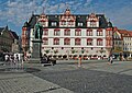
Coburg town house with Prince Albert monument

Kulmbach town hall with the traditional beer barrels on the occasion of the beer festival


The administrative district of Upper Franconia comprises four independent cities and nine rural districts :
One district cities
Counties
- Bamberg district
- Bayreuth district
- District of Coburg
- Forchheim district
- Hof district
- District of Kronach
- District of Kulmbach
- Lichtenfels district
- District of Wunsiedel in the Fichtel Mountains
Biggest cities
| city | district | Residents 1 | image |
|---|---|---|---|
| Bamberg | circular | 77.179 |

|
| Bayreuth | circular | 73,999 |

|
| court | circular | 45,950 |

|
| Coburg | circular | 41,236 |

|
| Forchheim | Forchheim | 32,125 |

|
| Kulmbach | Kulmbach | 26.002 |

|
| Lichtenfels | Lichtenfels | 20,158 |

|
| Marktredwitz | Wunsiedel in the Fichtel Mountains | 17,283 |

|
| Kronach | Kronach | 16,877 |

|
| Neustadt near Coburg | Coburg | 15,239 |
|
| Same | Wunsiedel in the Fichtel Mountains | 15.111 |

|
| Pegnitz | Bayreuth | 13,290 |

|
| Roedental | Coburg | 13,174 |
|
| Hirschaid 2 | Bamberg | 12,304 |

|
| Bad Staffelstein | Lichtenfels | 10,359 |

|
| Münchberg | court | 10,274 |

|
geography

High Fichtel Mountains (2006)
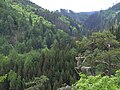
Hell Valley in the Franconian Forest

Saale valley at Hof

To Heil'gen Veit vom Staffelstein - Franconian landscape (2005)

Franconian Switzerland (2008)


Landscapes
- Coburg country
- Itzgrund
- Fichtel Mountains
- Franconian Forest
- Franconian Switzerland
- Bavarian Vogtland
- Hatred Mountains
- Obermainland / Obermainisches Hügelland
- Northern Franconian Alb
- Regnitz Valley
- Münchberger plateau
- Steigerwald
Rivers
- Main
- Saale
- Pegnitz
- Regnitz
- Kössein
- Röden
- Hasslach
- Itz
- Weismain
- Wiesent
- Rodach
- Kronach
- Steinach
- Selbitz
- Eger
- Ölschnitz (Roter Main)
- Ölschnitz (White Main)
- Röslau (river)
history
Prehistory and early history
Johann Friederich Esper described some caves in the Franconian Alb between 1774 and 1790 and J. B. Fischer excavated the grave mounds of Mistelgau in the Bayreuth district in 1788 . The earliest human presence is documented by tools made of Lydite from the Riss-Würm interglacial (120,000–800,000 BC), which were made by the Neanderthals . The next artefacts are a little more recent and come from the Presolutre of Kösten, a district of Lichtenfels . The early and middle Late Paleolithic has not yet been represented in Upper Franconia, and the Upper Paleolithic is indistinct. Evidence of Neolithic settlements of the band ceramics , which from 5500 BC Occurred in the area of the early Neolithic in the Main Valley . Here are u. a. more than 50 prehistoric earthworks or ring walls known, the size of which varies between 3 and 50 hectares. The largest are in Hetzles , Rödlas and Wiesenthau-Schlaifhausen in the Forchheim district and on the Staffelberg in Bad Staffelstein- Romansthal in the Lichtenfels district . But there are no grave finds at all. The most important sites are two caves, the Jungfernhöhle von Tiefenellern and the Hohle Stein near Schwabthal . Settlements from this period that were investigated are Altenbanz and Zilgendorf . The cultures that followed were not particularly well represented there until the early Bronze Age . There are still no settlements from the Middle Bronze Age. The hoard finds from Forchheim and Hollfeld, however, show the relatively sparse settlement in the early period. The presence of typical artifacts shows an orientation towards Hesse and Thuringia. In the Urnfield Period (1300–750 BC) the traces became clearer and the number of depots increased. Graves such as the so-called aristocratic grave of Eggolsheim in the Forchheim district provide an insight into the sepulchral culture . The subsequent Hallstatt period is strongly represented by graves and burial mounds, so that a more dense settlement can be assumed. In the La Tène period (500–100 BC) Upper Franconia was a core area of clay horse sculptures. Numerous finds of Roman origin have also been made.
Middle Ages and Modern Times
During the migration period, the Thuringians first extended their sphere of influence to Upper Franconia. After Clovis's victory over the Alemanni in the Battle of Zülpich in AD 496 , the western Main area initially came under Franconian influence. When the Thuringians were defeated in 531 ( Battle of Burgscheidungen ), the entire Main Valley came under Franconian rule. However, Slavic immigration could also be observed ( Bavaria Slavica ).
The area of today's Upper Franconia consisted essentially of the two historical territories of the bishopric of Bamberg and the Hohenzollern (since 1791/1792 Prussian ) principality of Bayreuth (also: Markgraftum Brandenburg-Bayreuth or earlier Brandenburg-Kulmbach). In addition, Upper Franconia, like Franconia in general, is characterized by many small-scale rulers, whose bearers were mainly recruited from the knighthood. Due to the large number of rulers in addition to the larger territorial lords, the Franconian area can be described as an "aristocratic landscape", which was unique in this form in the Old Kingdom . As a rule, the knights in Franconia were directly subordinate to the empire, i.e. only subject to the emperor . The Franconian knight circle was divided into the six cantons: Altmühl , Baunach , Gebirg , Odenwald , Rhön-Werra and Steigerwald . Most of the knight seats in what is now Upper Franconia belonged to the canton of mountains.
After the last margrave of Ansbach-Bayreuth, Karl Alexander , abdicated , the two Hohenzollern margravates passed to the Prussian line in Berlin. The Kingdom of Prussia under the leading minister Karl August von Hardenberg tried to push through ideas of modern statehood in the newly acquired Franconian provinces, e.g. B. through mediatization .
The representatives of the Franconian knighthood as well as other affected territorial lords turned to the Viennese court searching for the law in order to defend themselves against the attempts at mediation by Prussia. However, due to the strain of the coalition wars against revolutionary France, the emperor's influence was limited.
In 1795 Prussia concluded a separate peace with France ( Peace of Basel ). Now Prussia was able to enforce its mediatization policy in Franconia even more unhindered, which had been practically complete since the late 1790s. The Margraviate of Ansbach-Bayreuth were now closed territories, in which the general land law applied uniformly to the Prussian states .
After the military occupation of Bamberg by the Kingdom of Bavaria , the Bavarian Province of Bamberg was established on November 29, 1802 and renamed Mainkreis on October 1, 1808. The Kingdom of Bavaria bought the Margraviate Bayreuth, which was under French rule as a pays reservé ( Napoleon's private property) from 1806 to 1810, for 15 million francs from the French and took it over on June 30, 1810. This is how the Upper Main District with Bayreuth as the capital was created. The district has been called Upper Franconia since January 1, 1838, based on the Duchy of Franconia , in whose former eastern part it is located. The district was rounded off when the Free State of Coburg was incorporated into Bavaria on July 1, 1920 . In the course of state simplification, the governments of Upper Franconia and Middle Franconia were united in Ansbach in 1932/33 . In 1946 it was decided to restore the administrative district of Upper Franconia. The first elections for the District Day took place in 1954. Minor changes in the Upper Franconian area were finally brought about by the Bavarian territorial reform of 1972. Most of the Hochstadt an der Aisch district went to Middle Franconia, while communities from Lower Franconia and Upper Palatinate came to Upper Franconia. Sub-areas of Upper Franconia and the Upper Palatinate , a corridor from Hof to Weiden, to which Bayreuth also belongs, were the most densely industrialized area in Germany after the Ruhr area from the middle of the 19th century to the middle of the 20th century. There were close trade and economic ties with Thuringia and Saxony. According to estimates, there were around 34,000 mostly Eastern European forced laborers in Upper Franconia in autumn 1944 , who were mainly employed in industry.
After the end of the Second World War, the establishment of two German states and the construction of the Berlin Wall on August 13, 1961, the era of economic prosperity in this region ended. In order to bring the region forward economically, one resorted to structural policy measures. This included loosening up the industry structure and raising the quality level in order to guarantee competitiveness. With these measures, the constant population decline in the region could be stopped almost entirely. In order to keep young people, especially young graduates of high schools, in the area around Bayreuth and the northern Upper Palatinate and to give them future prospects, the decision was made in 1971 to establish the University of Bayreuth . Similar to Regensburg, whose university was founded in 1962, the establishment of a university in Bayreuth also led to a steady increase in population. The University of Bayreuth, whose cornerstone was laid south of the Kreuzstein and Birken districts in March 1974, began its research operations in the 1975/1976 winter semester. In addition, areas on the Red Hill and in Wendelhöfen were under discussion.
The situation was similar in Hof. After the University for Public Service in Bavaria was founded in 1974 , it was finally decided to move the Department of General Internal Administration to the city. In 1983, regular teaching could begin. In 1994 the decision was made to build the University of Applied Sciences in Hof in addition to the department of the University for Public Service . The campus is growing steadily, so that today several institutes have been added and the Einstein 1 digital start-up center was created. Student life is very much encouraged in the city.
economy
The Upper Franconian region has the second highest industrial density in Europe. Four times more hidden champions are located at the science and industry location than the national average. The innovative strength of the region can also be seen in the twice as high number of patent applications compared to the national average . In terms of gross domestic product , Upper Franconia is one of the wealthier regions of the EU with an index of 113 (EU27: 100, Germany: 116) (2008). More than a quarter of all companies are automotive suppliers .

The most important industrial sectors by number of employees are (as of September 2005):
- Plastic goods (16,100)
- Mechanical engineering (13,400)
- Ceramic and Glass (11,700)
- Metal Products (9900)
- Textiles (9400)
- food
Upper Franconia has a very high industrial density. The Hof-Bayreuth-Kulmbach area is one of the most important textile centers in Germany, the Wunsiedel district is the center of the German ceramics industry (household porcelain, hotel porcelain and technical ceramics), and the Lichtenfels- Coburg area is the center of the German upholstered furniture industry.
Tourism is important in the service sector.
The economic interest groups of Upper Franconia are the Chamber of Industry and Commerce for Upper Franconia Bayreuth, the Chamber of Industry and Commerce for Coburg and the Chamber of Crafts for Upper Franconia, based in Bayreuth.
media
The largest media company in Upper Franconia is the Upper Franconia Media Group , based in Bamberg . These include, above all, daily newspapers (including Fränkischer Tag , Bayerische Rundschau ), weekly newspapers , Internet newspapers ( inFranken.de ) and radio stations (Radio Bamberg, Radio Plassenburg). The Oberfranken media group - Fachverlage , based in Kulmbach , publishes trade journals, supplementary works and work aids .
In Hof is the second largest publishing house in Upper Franconia, the Frankenpost (editions Stadt- und Landkreis Hof, Fichtelgebirge, Naila-Münchberg and Kulmbach), as well as the weekly newspaper Blickpunkt . The city also has two radio stations, Radio Euroherz and Extra-Radio, as well as the only television station in the administrative district, TV Upper Franconia . The Bayerische Rundfunk maintains a correspondence office. Even filmmakers have settled in the city, for example, there is a filmmaking. The Hof Film Festival is of great importance for the film world in the city . According to the founder, the director Heinz Badewitz , HoF is the "Home of Films".
Bayerischer Rundfunk is based in Bamberg and Bayreuth .
Public facilities
The Upper Franconian Police Headquarters , together with the Federal Police and their three districts in Hof , Bamberg , Bayreuth and an inspection in Selb, ensure security. There is also the Federal Police Training and Advanced Training Center in Bamberg.
The Customs maintains the customs offices yard Marktredwitz , Coburg , Bayreuth and Bamberg. These are assigned to the main customs offices of Regensburg and Schweinfurt.
The THW maintains 13 local branches and 2 regional offices in Upper Franconia.
There are 20 hospitals and 14 specialist hospitals .
The Bundeswehr is represented by a company of the regional security and support forces (RSU) . The only remaining barracks of the Bundeswehr in Upper Franconia is in Hof . There are career counseling offices in Bayreuth and Bamberg.
Arts and Culture
From 1970 to 1990, the Bayreuth Chamber of Industry and Commerce awarded the Culture Prize of the Upper Franconian Economy annually, then roughly every two years until 2011, to people who have made outstanding contributions to cultural life in Upper Franconia.
In Bayreuth , the capital of Upper Franconia, the Richard Wagner Festival, also known as the Bayreuth Festival , takes place every summer .
.jpg)
The Upper Franconian District's KulturServiceStelle is housed in the Museum for Rural Tools in the old town of Bayreuth. In 2015, she chose an Upper Franconian Word of the Year for the first time , choosing “Wischkästla” (for smartphone ), but there were also other suggestions such as “Herrgottsmuggerla” (for ladybugs ) and “etzerla” ( but for now ). In 2016 the phrase “A weng weng” (in High German “A little bit”) was chosen, followed in 2017 by the expression “Urigeln” (the tingling sensation when cold hands and feet get warm again).
In addition, since 1967, found in the courtyard , the Hof International Film Festival instead. They were founded by Heinz Badewitz , who was born in Hof. The focus is primarily on film productions from German film schools.

One of the most important orchestras in Bavaria is based in Hof. The Hofer Symphoniker are an international orchestra that is also socially committed several times. Enoch zu Guttenberg was honorary conductor of the Hof Symphony Orchestra.
The Hof Zoological Garden is the only zoo in Upper Franconia. It opened in 1954. Its inhabitants are u. a. Reptiles, amphibians, ring-tailed lemurs, gibbons and native animal species. The Geological Garden is also located on the zoo grounds. There the course of the Saale is shown with vegetation and types of rock.

tourism
One district cities
Tourism is an industry that is becoming increasingly important. The largest tourist city in Upper Franconia is the Unesco World Heritage City of Bamberg . Also due to the river cruises on the Main-Danube Canal , the city is one of the most important tourist spots in Bavaria . The city with the second most tourists is Bayreuth . Many visitors come to the Bayreuth Festival , but also to the Margravial Opera House . Hof ranks third in tourism in Upper Franconia. The sights such as the city center , the Theresienstein , the Botanical and the Zoological Gardens are important for tourism . Culture is also an important factor with the theater , the Freiheitshalle , the Symphoniker and the Hof Film Festival . Tourism is also important in the Vestestadt Coburg . Sights are the old town, the Veste Coburg , the Ehrenburg Castle and the Coburg State Theater .
More Attractions
Other sights in Upper Franconia are the Vierzehnheiligen basilica , Pottenstein Castle and Plassenburg . Natural beauties are the Franconian Switzerland with the Teufelshöhle in Pottenstein , the Main , the Saale , the Itzgrund , the Steigerwald , the Franconian Forest and the Fichtelgebirge .
Protected areas
In the administrative district there are 95 nature reserves , 70 landscape protection areas , 113 FFH areas , nine EU bird protection areas and at least 565 designated geotopes . The largest nature reserve in the district is the shell limestone area on Oschenberg .
See also:
- List of nature reserves in Upper Franconia
- List of landscape protection areas in Upper Franconia
- List of FFH areas in Upper Franconia
- List of EU bird protection areas in Upper Franconia
- List of geotopes in Upper Franconia
traffic
Street
Several motorways with connections to all major cities run through Upper Franconia. In the west the A 73 (Nuremberg – Suhl) leads from Forchheim via Bamberg and Lichtenfels to Coburg, in the east the A 9 (Berlin – Munich) connect Pegnitz, Bayreuth, Kulmbach and Hof and the A 93 (Hof – Holledau) Marktredwitz, Wunsiedel and Selb with yard. The A 70 (Schweinfurt – Bayreuth / Kulmbach) creates a cross connection between A 73 and A 9 and connects the two largest Upper Franconian cities, Bamberg and Bayreuth. A section of the A 72 between Hof and Trogen and a section of the A 3 at Schlüsselfeld lead through Upper Franconia .
The following federal highways run through Upper Franconia:

Lanes

Bamberg train station

Hof Hauptbahnhof


The only ICE system stop in Upper Franconia is Bamberg , which is served almost every hour by trains on the Hamburg – Berlin – Munich line. Individual pairs of trains also stop in Coburg . There is also an ICE connection from Lichtenfels to Munich on weekdays . In addition, a daily IC train pair on line 61 Karlsruhe – Leipzig via Bamberg, Lichtenfels and Kronach is in the timetable. In the future, the Intercity line 65 will run from Munich via Hof to Dresden or on to Berlin .
The electrified routes in western Upper Franconia between Forchheim, Bamberg, Lichtenfels, Coburg and Kronach are opened up in regional traffic by the Franconia-Thuringia Express . In addition, the S1 line of the Nuremberg S-Bahn runs on its northernmost section through Upper Franconia. The non-electrified routes in eastern Upper Franconia connect Bayreuth , Kulmbach , Hof and Marktredwitz are served by diesel trains. From Hof there are electrified connections to Leipzig and Dresden . In 2011 agilis took over operation on the region's non-electrified local transport routes.
Electrified routes that run through Upper Franconia are:
- High-speed line from Nuremberg to Erfurt
- Nuremberg – Bamberg
- Bamberg – Rottendorf
- Bamberg – Hochstadt-Marktzeuln
- Coburg-Lichtenfels
- Coburg-Sonneberg
- Hochstadt-Marktzeuln – Probstzella
- Leipzig-Hof
In addition, the following non-electrified main and branch lines are operated:
- Nuremberg northeast - Graefenberg
- Forchheim – Ebermannstadt
- Breitengüßbach – Ebern
- Coburg – Bad Rodach
- Hochstadt-Marktzeuln-Hof
- Bayreuth-Neuenmarkt-Wirsberg
- Bayreuth – Weidenberg
- Weiden-Bayreuth
- Schnabelwaid – Bayreuth
- Münchberg – Helmbrechts
- Hof – Bad Steben
- Cheb – Oberkotzau
- Regensburg – Oberkotzau
- Selb-Plößberg-Selb town
- Nuremberg – Cheb
The Strullendorf – Schlüsselfeld and Bamberg – Bamberg Hafen routes are only used for freight traffic, the Ebermannstadt – Behringersmühle and Steinwiesen – Nordhalben routes are only used by museums.
Flight connections
- None - only private and company flights, etc. a. from the Hof-Plauen airfield
Bike paths
Hiking trails
- Short stretch of the Rennsteig
- Frankenweg
- Franconian mountain trail
- Frankish Stone Empire
- High trails in the Fichtel Mountains
- Main-Danube-Path ( Bad Staffelstein - Regensburg )
- Main hiking trail
- Saar-Schlesien-Weg
- Jean-Paul Way
District of Upper Franconia
The district of Upper Franconia , together with the other Bavarian districts, forms the third municipal level in the state. The core tasks of the district are in the social and cultural area. The organs of the district are the district assembly , the district committee and the district assembly president ( Art. 21 District Code - BezO ).
District day
composition
| choice | CSU | SPD | FW | Green | FDP | REP | NPD | GDP 1 | BP | The Franks | The left | AfD | total |
|---|---|---|---|---|---|---|---|---|---|---|---|---|---|
| 2018 | 8th | 3 | 3 | 3 | 1 | 1 | 2 | 21st | |||||
| 2013 | 8th | 4th | 2 | 1 | 1 | 1 | 17th | ||||||
| 2008 | 9 | 4th | 2 | 1 | 1 | 17th | |||||||
| 2003 | 10 | 5 | 1 | 1 | 17th | ||||||||
| 1998 | 10 | 8th | 1 | 1 | 20th | ||||||||
| 1994 | 11 | 8th | 1 | 20th | |||||||||
| 1990 | 11 | 7th | 1 | 1 | 20th | ||||||||
| 1986 | 13 | 7th | 1 | 21st | |||||||||
| 1982 | 13 | 8th | 21st | ||||||||||
| 1978 | 12 | 9 | 21st | ||||||||||
| 1974 | 13 | 9 | 22nd | ||||||||||
| 1970 | 13 | 10 | 23 | ||||||||||
| 1966 | 10 | 10 | 1 | 2 | 23 | ||||||||
| 1962 | 12 | 11 | 1 | 1 | 1 | 25th | |||||||
| 1958 | 11 | 10 | 1 | 2 | 1 | 25th | |||||||
| 1954 | 8th | 9 | 2 | 3 | 3 | 25th |
District President
After setting up the districts as higher municipal associations, they also received a legislature. This was initially called District Administrator, whose members were district administrators, the chairmen of the committee were called President of the District Council (1829-1919), President of the District Council (1919-1933), President of the District Association. Since 1954 they have been called the Presidents of the District Assembly.
- 1829–1830 Franz Ludwig von Hornthal
- 1832–1833 Karl von Dorbenck
- 1833–1833 August Voit of Salzburg
- 1834–1836 Karl von Dorbenck
- 1837–1839 Christian von Landgraf
- 1840–1841 Carl von Redwitz
- 1841–1842 Ernst von Waldenfels
- 1843–1844 Carl Vetterlein
- 1846–1848 Ernst von Waldenfels
- 1848–1851 Karl von Dorbenck
- 1852–1863 Oskar von Seefried
- 1863–1868 Moritz Steinhäuser
- 1868–1879 Julius von Rotenhan
- 1879–1900 Theodor von Muncker
- 1900–1908 Joseph Ritter von Schmitt
- 1908–1919 Alexander von Feilitzsch
- 1919–1928 Adolf Wächter
- 1929–1933 Nikolaus Schmidt
- 1933–1938 vacancy
- 1938–1942 Willy Liebel (responsible for Upper and Middle Franconia)
- 1942–1954 vacancy
- 1954–1962 Hans Rollwagen ( SPD )
- 1962–1982 Anton Hergenröder (CSU)
- 1982-2003 Edgar Sitzmann (CSU)
- 2003-2018 Günther Denzler (CSU)
- since 2018 Henry Schramm (CSU)
Administrative district
The administrative district of Upper Franconia is geographically identical to the District of Upper Franconia. He is the area of responsibility of the state middle authority government of Upper Franconia .
District President of Upper Franconia
(until 1837 general commissioners )
| Term of office | District President |
| 1810-1814 | Friedrich Karl von Thürheim |
| 1815-1832 | Constantin Ludwig von Welden |
| 1832-1837, 1838-1840 | Ferdinand von Andrian-Werburg |
| 1840-1857 | Melchior Knight of Stenglein |
| 1858-1863 | Friedrich von Podewils |
| 1863-1864 | Nikolaus von Koch |
| 1864-1868 | Theodor von Zwehl |
| 1868-1873 | Ernst von Lerchenfeld |
| 1873-1876 | Hugo of Herman |
| 1876-1893 | Karl Alexander von Burchtorff |
| 1893-1909 | Rudolph von Roman |
| 1909-1916 | Gustav von Brenner |
| 1916-1932 | Otto von Strössenreuther |
| 1933–1934 * | Hans Georg Hofmann |
| 1934–1944 * | Hans Dippold |
| 1944–1945 * | Heinrich Detloff von Kalben |
| 1945 * | Privy Councilor Ernst Reichard |
| 1945–1948 * | Hans Schregle |
| 1948-1956 | Ludwig Gebhard |
| 1957-1973 | Fritz Stahler |
| 1973-1989 | Wolfgang Winkler |
| 1989-1998 | Erich Haniel |
| 1998-2006 | Hans Angerer |
| 2006-2016 | Wilhelm Wenning |
| 2016– | Heidrun Piwernetz |
Note: 1933 to 1948 joint district president with Middle Franconia
literature
- Björn-Uwe Abels : Archaeological Guide Upper Franconia. Theiss: 1986, ISBN 3-8062-0373-3 .
- Björn-Uwe Abels, Walter Sage, Christian Züchner: Upper Franconia in prehistoric times. Bayreuth 1986, ISBN 3-87052-991-1 .
- Franz X. Bogner: Upper Franconia from the air. Ellwanger-Verlag, 128 pages, Bayreuth 2011. ISBN 978-3-925361-95-1 .
- Franz X. Bogner: Franks from the air. Stürtz Verlag, 136 pages, Würzburg 2008 ,. ISBN 978-3-8003-1913-8 .
- Helmut Haberkamm , Annalena Weber: Small collection of Franconian villages . Cadolzburg : ars vivendi Verlag , 2018. ISBN 978-3-86913-990-6 .
- Circle of Bavarian Scholars (Ed.): Upper Franconia and Middle Franconia (= Bavaria. Regional and Folklore of the Kingdom of Bavaria . Volume 3 ). Literary and artistic establishment of the JG Cotta'schen Buchhandlung, Munich 1865, DNB 56034290X , p. 1-746 ( digitized version ).
- Georg Krauss: The Upper Franconian History. Hof 1982.
- Jörg Maier (Ed.): Flight over Upper Franconia. Bayreuth 1995, ISBN 3-922808-13-1 .
- Ralf Nestmeyer : Franconia. A travel guide. Michael-Müller-Verlag, 6th edition, Erlangen 2013, ISBN 978-3-89953-775-8 .
- Elisabeth Roth (Ed.): Upper Franconia in the 19th and 20th centuries. Bayreuth 1990, ISBN 3-87052-992-X .
- Otto Meyer, Elisabeth Roth, Klaus Guth: Upper Franconia in the High Middle Ages. Bayreuth 1973.
- Elisabeth Roth (Ed.): Upper Franconia in the late Middle Ages and at the beginning of the modern era. Bayreuth 1979.
- Elisabeth Roth (Hrsg.): Upper Franconia in the modern age up to the end of the Old Kingdom. Bayreuth 1984, ISBN 3-87052-990-3 .
- Enrico Santifaller: Current architecture in Upper Franconia. Büro Wilhelm Verlag, Amberg 2008, ISBN 978-3-936721-33-1 .
- Enrico Santifaller: Current Architecture in Upper Franconia 2. Büro Wilhelm Verlag, Amberg 2016, ISBN 978-3-943242-60-7 .
- Pleikard Joseph Stumpf : Upper Franconia . In: Bavaria: a geographical-statistical-historical handbook of the kingdom; for the Bavarian people . Second part. Munich 1853, p. 541-656 ( digitized version ).
Web links
- Literature from and about Upper Franconia in the catalog of the German National Library
- Upper Franconia - Government of Upper Franconia
- Location marketing for Upper Franconia with lots of information about the location
- Link catalog on Upper Franconia at curlie.org (formerly DMOZ )
- Upper Franconia: Official statistics of the LfStat
Individual evidence
- ↑ "Data 2" sheet, Statistical Report A1200C 202041 Population of the municipalities, districts and administrative districts 1st quarter 2020 (population based on the 2011 census) ( help ).
- ↑ a b c d on December 31, 2017, source: Bamberg is growing fastest in: Nordbayerischer Kurier from September 28, 2018, p. 1.
- ^ Rudolf Endres: State and Society. Second part: 1500-1800 . In: Andreas Kraus (Ed.): Handbook of Bavarian History. 3. Edition. tape III , Part I: History of Franconia up to the end of the 18th century. Munich 1997, p. 740 .
- ^ Rudolf Endres: State and Society. Second part: 1500-1800 . In: Andreas Kraus (Ed.): Handbook of Bavarian History. 3. Edition. tape III , Part I: History of Franconia up to the end of the 18th century. Munich 1997, p. 740 .
- ^ Rudolf Endres: State and Society. Second part: 1500-1800 . In: Andreas Kraus (Ed.): Handbook of Bavarian History . 3. Edition. tape III , Part I: History of Franconia up to the end of the 18th century. Munich 1997, p. 745 .
- ^ Kurt Andermann: Imperial Knighthood. In: Historical Lexicon of Bavaria. Retrieved November 21, 2017 .
- ^ Rudolf Endres: State and Society. Second part: 1500-1800 . In: Andreas Kraus (Ed.): Handbook of Bavarian History . 3. Edition. tape III , Part I: History of Franconia up to the end of the 18th century. Munich 1997, p. 772 .
- ^ Rudolf Endres: State and Society. Second part: 1500-1800 . In: Andreas Kraus (Ed.): Handbook of Bavarian History . 3. Edition. tape III , Part I: History of Franconia up to the end of the 18th century. Munich 1997, p. 773 .
- ^ Rudolf Endres: State and Society. Second part: 1500-1800 . In: Andreas Kraus (Ed.): Handbook of Bavarian History . 3. Edition. tape III , Part I: History of Franconia up to the end of the 18th century. Munich 1997, p. 773 f .
- ^ Rudolf Endres: State and Society. Second part: 1500-1800 . In: Andreas Kraus (Ed.): Handbook of Bavarian History . 3. Edition. tape III , Volume i: History of Franconia up to the end of the 18th century. Munich 1997, p. 777 .
- ↑ When Hitler visited the Teufelshöhle in: Nordbayerischer Kurier of December 9, 2019, p. 15.
- ^ University of Bayreuth: Development Plan . Bayreuth 1976, p. 4-9 .
- ^ Kraus, Andreas: History of Bavaria. From the beginning to the present . Munich 2004, p. 747 .
- ↑ Boß, Daniela, et al .: Upper Franconia facing major challenges: A regional analysis of development opportunities and qualification needs in Upper Franconia. November 7, 2017, accessed May 13, 2020 .
- ↑ Innovation Prize Upper Franconia. Oberfranken Offensiv eV, accessed on March 18, 2016 .
- ↑ https://www.pictame.com/user/filmemacherei.hof/45281904
- ↑ Federal Police - Search for offices. Retrieved June 25, 2020 .
- ↑ Bavarian Police - Police Headquarters Upper Franconia. Retrieved June 25, 2020 .
- ^ Customs online - structure - organization plans of the local authorities. Retrieved June 25, 2020 .
- ↑ THW on site. Retrieved June 25, 2020 .
- ↑ Hospitals | Government of Upper Franconia. Retrieved June 25, 2020 .
- ^ Bavarian State Regiment. Retrieved June 25, 2020 .
- ↑ courtyard. Retrieved June 25, 2020 .
- ↑ Advice center finder . Retrieved June 25, 2020 .
- ↑ Culture Prize of the Upper Franconian Economy. www.kulturpreise.de, 2013, accessed on October 4, 2016 .
- ↑ KulturServiceStstelle of the district of Upper Franconia. (No longer available online.) KulturServiceStelle, archived from the original on December 8, 2015 ; Retrieved December 5, 2015 . Info: The archive link was inserted automatically and has not yet been checked. Please check the original and archive link according to the instructions and then remove this notice.
- ↑ “Wischkästla” is the first Upper Franconian word of the year. (No longer available online.) District of Upper Franconia, November 28, 2015, archived from the original on December 8, 2015 ; Retrieved December 5, 2015 . Info: The archive link was inserted automatically and has not yet been checked. Please check the original and archive link according to the instructions and then remove this notice.
- ↑ Upper Franconian Word of the Year 2016: "A weng weng". (No longer available online.) District of Upper Franconia, September 26, 2016, archived from the original on October 1, 2016 ; accessed on October 1, 2016 . Info: The archive link was inserted automatically and has not yet been checked. Please check the original and archive link according to the instructions and then remove this notice.
- ↑ Old word rediscovered: “Urigeln” is the Upper Franconian word of the year 2017. District of Upper Franconia, October 1, 2017, accessed on October 7, 2017 .
- ^ Government of Upper Franconia: State Parliament and District Elections 2018 | Government of Upper Franconia. Retrieved November 2, 2018 .
- ↑ Walter Schärl: The composition of the Bavarian civil service from 1806 to 1918 (= . Munich historical studies department Bavarian History Volume 1.). Lassleben, Kallmünz 1955, DNB 454302959
- ↑ Julius Meyer, Adolf Bayer: Brügels Onoldina - Heimatkundliche Abhandlungen für Ansbach and surroundings, Book II (résumés, mayors, regional presidents, etc.) , C. Brügel & Sohn, Ansbach 1955. pp. 107 to 126.
- ↑ Stefan Nöth, Klaus Rupprech (ed.): The presidents. 200 years of government of Upper Franconia in Bayreuth. , Bamberg State Archives, 2010
Coordinates: 50 ° 4 ′ N , 11 ° 20 ′ E