
Itzgrund
| coat of arms | Germany map | |
|---|---|---|

|
Coordinates: 50 ° 9 ' N , 10 ° 54' E |
|
| Basic data | ||
| State : | Bavaria | |
| Administrative region : | Upper Franconia | |
| County : | Coburg | |
| Height : | 320 m above sea level NHN | |
| Area : | 33.08 km 2 | |
| Residents: | 2292 (Dec. 31, 2019) | |
| Population density : | 69 inhabitants per km 2 | |
| Postal code : | 96274 | |
| Primaries : | 09533, 09573 | |
| License plate : | CO, NEC | |
| Community key : | 09 4 73 138 | |
| LOCODE : | DE IZD | |
| Community structure: | 6 districts | |
| Address of the municipal administration: |
Rathausstrasse 4 96274 Itzgrund |
|
| Website : | ||
| Mayor : | Nina Liebermann ( CSU ) | |
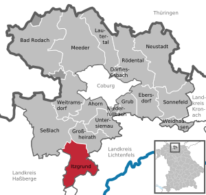
| Location of the municipality of Itzgrund in the Coburg district | ||
  |
||


Itzgrund is a municipality in the Upper Franconian district of Coburg . The seat of the municipal administration is in Kaltenbrunn.
geography
Geographical location
The community is located in the middle of Itzgrund on federal highway 4 between Coburg and Bamberg in a varied landscape, to the left and right of the River Itz .
Neighboring communities
The municipality borders (clockwise from the northwest) on the city of Seßlach , the municipality of Großheirath (both district of Coburg), the city of Bad Staffelstein , the market Ebensfeld (both of the district of Lichtenfels ), the market of Rattelsdorf ( district of Bamberg ) and the community of Untermerzbach ( District of Haßberge , Lower Franconia ).
Community structure
The community consists of the districts (former communities with their former districts):
|
There is no part of the municipality of Itzgrund, but the town hall address is "96274 Itzgrund".
history
Community development
The municipality of Itzgrund was established on May 1, 1978 as part of the municipal area reform from the previously independent municipalities of Gleußen, Kaltenbrunn (with Herreth, which was incorporated on July 1, 1972, until 1863 "Kleinhereth"), Lahm, Schottenstein and Welsberg June 1972 belonged to the district of Staffelstein .
Until January 1, 1980, the community was a member of the Untersiemau administrative community .
Religions
The Protestant Christians in the community are divided between the Evangelical Lutheran parishes of Lahm, Gleußen, Schottenstein and Bad Staffelstein with Herreth of the Michelau deanery of the Evangelical Lutheran Church in Bavaria . The Catholics belong to the parishes Altenbanz of the deanery of Lichtenfels and Kaltenbrunn and Seßlach of the deanery of Coburg in the archdiocese of Bamberg .
Population development
In the period from 1988 to 2018, the community grew from 1854 to 2308 by 454 inhabitants or 24.5%.
| year | Residents | year | Residents | year | Residents |
|---|---|---|---|---|---|
| 1840 | 1968 | 1950 | 2635 | 1995 | 2047 |
| 1871 | 2079 | 1961 | 1941 | 2005 | 2317 |
| 1900 | 1914 | 1970 | 1866 | 2010 | 2303 |
| 1925 | 1860 | 1987 | 1825 | 2015 | 2286 |
| 1939 | 1723 | 1991 | 1946 |
politics
Municipal council
The 2020 local election resulted in the following distribution of seats in the local council (compared to the 2014 election)
- CSU / Landvolk 4 seats (± 0)
- SPD 3 seats (−2)
- Free voter group Itzgrund 4 seats (−1)
- Municipal Independent List Itzgrund 3 seats (+3)
mayor
Werner Thomas (SPD) was mayor from 1996 until he left in 2020. He was followed on May 1, 2020 by Nina Liebermann (CSU).
coat of arms
|
|
Blazon : "Under red and silver in the tip section geviertem Sign High in gold a black crowned and -bewehrter red Basilisk with upwardly turned horseshoe that supports his left claw on a gevierten of silver and red sign" |
Culture and sights
Buildings
- Gleußen district: old post office from 1603, neo-classical Protestant-Lutheran parish church
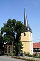
- District Herreth: Evangelical St. James Church from 1694
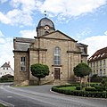
- District Kaltenbrunn: Catholic parish church St. Wolfgang from 1748/49 with Rococo furnishings
- District Lahm: Ensemble with baroque castle of the Barons of Lichtenstein (around 1710), Castle Church of the Holy Trinity with autumn organ from 1732 , former farm buildings and park with castle pond
- District of Schottenstein: Evangelical parish church of St. Pankratius from 1703
education
The Oskar Schramm School Itzgrund in the Bodelstadt district is a primary school.
Sons and daughters of the place
- Hans Bohla (1891–1928), politician (member of the Reichstag) and journalist, born in the Herreth district
- Torsten Oehrl (* 1986), soccer player
Others
The Main Franconian dialect Itzgründisch is spoken in Itzgrund . The dialect name, however, stands for a much larger language area and is much older than the municipality of Itzgrund.
Church images
Evangelical Church in Gleussen

Evangelical St. James Church in Herreth

Catholic Church St. Wolfgang in Kaltenbrunn
Evangelical castle church in Lahm

Evangelical Church in Schottenstein


Web links
- Local government
- Touristikverein Itzgrund e. V.
- Itzgrund: Official statistics of the LfStat (PDF, 1.66 MB)
Individual evidence
- ↑ "Data 2" sheet, Statistical Report A1200C 202041 Population of the municipalities, districts and administrative districts 1st quarter 2020 (population based on the 2011 census) ( help ).
- ^ Wilhelm Volkert (ed.): Handbook of Bavarian offices, communities and courts 1799–1980 . CH Beck, Munich 1983, ISBN 3-406-09669-7 , p. 575 .
- ^ Federal Statistical Office (ed.): Historical municipality directory for the Federal Republic of Germany. Name, border and key number changes in municipalities, counties and administrative districts from May 27, 1970 to December 31, 1982 . W. Kohlhammer GmbH, Stuttgart / Mainz 1983, ISBN 3-17-003263-1 , p. 680 .
- ↑ Mayor. Itzgrund municipality, accessed on August 26, 2020 .
- ↑ Entry on Itzgrund's coat of arms in the database of the House of Bavarian History

Maple | Bad Rodach | Dörfles-Esbach | Ebersdorf near Coburg | Great marriage | Grub am Forst | Itzgrund | Lautertal | Meeder | Neustadt bei Coburg | Niederfüllbach | Rödental | Seßlach | Sonnefeld | Untersiemau | Weidhausen near Coburg | Weitramsdorf
Unregulated areas of
Callenberger Forst-West |
Gellnhausen |
Köllnholz