
Sesslach
| coat of arms | Germany map | |
|---|---|---|

|
Coordinates: 50 ° 11 ' N , 10 ° 51' E |
|
| Basic data | ||
| State : | Bavaria | |
| Administrative region : | Upper Franconia | |
| County : | Coburg | |
| Height : | 271 m above sea level NHN | |
| Area : | 72.54 km 2 | |
| Residents: | 3922 (Dec. 31, 2019) | |
| Population density : | 54 inhabitants per km 2 | |
| Postal code : | 96145 | |
| Primaries : | 09569, 09567 | |
| License plate : | CO, NEC | |
| Community key : | 09 4 73 165 | |
| City structure: | 15 districts | |
City administration address : |
Marktplatz 98 96145 Seßlach |
|
| Website : | ||
| Mayor : | Maximilian Neeb (Free Voters) | |
| Location of the city of Sesslach in the Coburg district | ||
  |
||

Seßlach is a town in the Upper Franconian district of Coburg . Seßlach has an extraordinarily well-preserved medieval townscape and became known nationwide as a historical film set.
geography
Neighboring communities
Seßlach borders (clockwise from the northwest) on the city of Heldburg , the municipality of Ummerstadt ( district of Hildburghausen , Thuringia ), the communities of Weitramsdorf , Ahorn , Großheirath , Itzgrund (district of Coburg), the communities of Untermerzbach , Pfarrweisach and the market Maroldsweisach ( district of Haßberge , Lower Franconia ).
City structure
Seßlach is divided into 17 districts:
(residents on July 2, 2015)
- Autenhausen (312)
- Bischwind (101)
- Dietersdorf (426)
- Eckersdorf (25)
- Gemünda (522)
- Gleismuthhausen (99)
- Hattersdorf (133)
- Heilgersdorf (454)
- Krumbach (74)
- Lechenroth (73)
- Merlach (83)
- Oberelldorf (142)
- Rothenberg (94)
- Sesslach (1248)
- Setzelsdorf (36)
- Unterelldorf (146)
- Meadows (25)
history


Until the 19th century
After the Thuringian Empire was smashed in 531, the Grabfeldgau was settled by Franconian farmers. Slavic settlers, fleeing from their Avar oppressors , also penetrated the Upper Main area from the east . In the 11th century, numerous Slavs in Franconia were not yet Christianized. As original parishes of the Diocese of Würzburg were u. a. Baunach , Pfarrweisach and Seßlach laid out. The patron saint of Sesslach, St. John the Baptist , as a missionary saint , refers to the parish's function as a base for the Slavic mission . In 1007 the Bamberg diocese was founded in the Slavic region.
The first documentary mention of the two settlements on the Kirchhügel and the Geiersberg was in the year 800 AD. In this document, the abbess Emhild of the Milz Abbey transferred the Milz goods to "Duo Sezelaha" together with the rest of the monastery property.
As early as 837 another document spoke of “Sezzilahono marca” when Gaugraf Asis, a grandson of Charlemagne , also bequeathed his possessions to the Fulda Abbey.
After the Würzburg bishop was enfeoffed with the Duchy of Franconia by Emperor Heinrich V in 1120 , Sesslach was designated the official seat and central court . In 1154 a Hugo von Sezzelah appeared as a servant from Würzburg at Geiersberg Castle above the town. The castle should have been built around 1120/30.
In 1223 the settlement was named "Sezzelaha" in a document. It was destroyed in 1244 in a conflict between Duke Otto VIII of Meran and the Würzburg monastery .
In 1335 Emperor Ludwig the Bavarian granted the Civitas town and fortification rights based on the model of the town of Gelnhausen . The neighboring town of Ebern was also upgraded in this way.
In 1399 the citizens of Seßlach joined the League of Eleven Cities against the Würzburg bishopric . At that time the cities tried to break away from their dependence on the bishopric and to achieve the status of imperial immediacy . This alliance was broken in 1400 at the Battle of Bergtheim . The approximately 60 knights and servants from the neighboring Haßbergen played a decisive role in the defeat of the league of cities .
The participation of the citizens in the Peasants' War of 1525 also ended tragically. The Würzburg bishop Konrad had five ringleaders beheaded in the market square after judging eleven men in nearby Ebern on the same day.
During the Thirty Years War there were several pillages and pillages. When the imperial troops stormed the city, there were not only many injuries but also six deaths (1640). The soldiers who were actually allied had found the city gates locked.
During the Napoleonic Wars , Seßlach suffered from billeting and raising troops. In 1802 the Würzburg monastery was secularized . Seßlach finally came to the Kingdom of Bavaria via the Grand Duchy of Würzburg in 1810 . In 1812 the royal district court (from 1879 district court Seßlach in the district office Staffelstein ) was established. In 1840 Seßlach had 665 inhabitants. In Seßlach, there has been evidence of a medieval leprosorium on a "mons leprosorum" that was dedicated to Nicholas since 1361 . Later, a chapel from the leprosy was preserved.
20th century
In 1905, 13 houses and numerous barns and outbuildings fell victim to a major fire around the market square. The subsequent historicizing new building blends in well with the old townscape despite some Art Nouveau elements. On October 1, 1913, Seßlach was connected to the railway network with the Breitengüßbach – Dietersdorf railway.

During the Second World War , the city surrendered to the advancing Americans on April 9, 1945 without a fight. During the advance through the Rodachtal, however, there was some damage in the districts of Rothenberg, Oberelldorf and Dietersdorf.
When Germany was divided, Seßlach lost its hinterland in southern Thuringia . In particular, the connections to the neighboring town of Heldburg were completely interrupted. However, they had already largely oriented themselves to the south and west. Due to the settlement of numerous refugees and displaced persons , the medieval town grew far beyond its historic city walls. The number of inhabitants almost doubled and large new building areas were built.
In 1971 the community began to renovate the historic old town. In 1986/87 Seßlach won the title of state or national winner for exemplary urban redevelopment.
In 1985 the city celebrated its 650th anniversary. With the opening of the Iron Curtain in 1989, the city lost its unfavorable peripheral location on the inner-German border . The old connections to Thuringia could in part be quickly restored. The historic townscape, which is rarely complete, attracts numerous tourists from home and abroad.
Administrative affiliation
On July 1, 1972, the Seßlacher Land was added to the district of Coburg in the course of the regional reform, despite the historical connections to Lower Franconia. However, the area already belonged to the disbanded district of Staffelstein and thus to Upper Franconia.
Incorporations
On May 1, 1975, the previously independent municipality of Oberelldorf was incorporated. Gleismuthhausen was added on January 1, 1977. Lechenroth followed on October 1, 1977. The series of incorporations was established with the incorporation of Hattersdorf on January 1, 1978 as well as Autenhausen, Dietersdorf, Gemünda in Upper Franconia, Heilgersdorf (with its districts including the Bischwind, which was incorporated on July 1, 1971), Merlach, Rothenberg and Unterelldorf completed on May 1, 1978.
Population development
In the period from 1988 to 2018, the city grew from 3773 to 3934 by 161 inhabitants or 4.3%. A peak was reached on December 31, 2001 with 4,140 inhabitants.
politics
City council
The 2020 local elections resulted in the following distribution of seats (compared to 2014):
- CSU / Landvolk 5 seats (−3)
- SPD 3 seats (0)
- Free voter group Citizen block 8 seats (+3)
mayor
Maximilian Neeb (Free Voters) has been the first mayor since 2019. His predecessor was Martin Mittag (CSU) from 2014 until his election to the Bavarian State Parliament in 2018 . Its predecessor was Hendrik Dressel (Free Voters), who was first elected in 1984.
coat of arms
Description : In red the bearded, silver clad Saint John the Baptist, who sits on a silver chest bench and holds up a gold disc with the silver lamb of God with both hands.
Culture and sights


The old town of Seßlach is still almost completely surrounded by its late medieval wall ring. The loose pebbles on the top of the wall instead of a battlement are unusual . The three gate towers have also been preserved. The fortifications of the Würzburg official city were built in the 14th and 15th centuries. Century and was expanded in the 16th and 17th centuries. In front of the Rothenberger Tor, a baroque arched bridge complements the historical ensemble.
In addition to numerous residential and commercial buildings from the 16th to 18th centuries Century, the representative episcopal official buildings and the Gülthof of the Würzburg Juliusspital shape the picturesque townscape. Some houses in the "Heimatstil" of the early 20th century were built after the great fire of 1905.
The late Gothic staggered hall of the Catholic parish church of St. John the Baptist was redesigned in Baroque style in the 18th century. From the older equipment especially some are Renaissance - epitaphs of the family of Lichtenstein highlight and a late Gothic altarpiece. In front of the Hattersdorfer Tor on the road to Dietersdorf stands the baroque cemetery chapel Heilig Kreuz
Geiersberg Castle is located on a hill above the city . The medieval castle of Lichtsteiner remnants of the recall curtain wall and the keep . The main building with its stair tower dates back to the 17th century, when the castle was the seat of the Würzburg bailiff. The farm buildings date from the 18th century.
The Heilgersdorf Castle in the district Heilgersdorf is a typical example of a Franconian castle. The baroque three-wing building can only be viewed from the outside.
The stately saddle roof construction of Wiesen Castle between Seßlach and Heilgersdorf dates back to the 16th century. This former aristocratic residence is also privately owned and is not accessible.
Architectural monuments
Economy and Transport
The largest industrial company in the municipality is Geiss AG with 158 employees (as of 2019) in Seßlach. The company, founded in 1948, manufactures machine tools for processing plastics.
Movie and TV
In the old town, on the historic market square and in front of the historic city wall, parts of some films were shot:
- Luther with Joseph Fiennes and Sir Peter Ustinov
- The robber Hotzenplotz with Armin Rohde and Katharina Thalbach
Others
Seßlach is home to one of the few still active community breweries. In the communal brewery, built in 1892, brown country beer is always produced on Fridays and, depending on the season, bock beer is also produced. 1300 to 1500 hectoliters are brewed annually and given as home brew to two inns.
Personalities
sons and daughters of the town
- Siegismund Justus Ehrhardt (* 1732 in Gemünda; † 1793 in Beschine), Protestant theologian, diplomat and church historian
- Heinrich Stephani (* 1761 in Gemünda, † 1850 in Gorka, Silesia), educator and school reformer
- Joseph Otto Kolb (* 1881 in Seßlach; † 1955 in Bamberg), Archbishop of Bamberg 1943 to 1955
- Heinrich Eckstein (* 1907 in Autenhausen, † 1992 in Aschaffenburg), politician (CDU)
- Friedrich Schaller (* 1920 in Gleismuthhausen; † 2018 in Vienna), zoologist
- Robert Hartmann (* 1949 in Seßlach), painter
Other personalities
- Friedrich Rückert (1788–1866), poet and founder of German oriental studies, wrote his first poems with his parents in Seßlach (1807/09).
- Andreas Krämmer (* 1959), sculptor, lives and works in Seßlach.
Churches of the districts
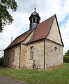
Bischwind, Evang.-Luth. church
Dietersdorf, Catholic branch church St. Kilian
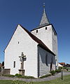
Gemünda, Evang.-Luth. Johanniskirche

Gleismuthhausen, Catholic branch church St. Antonius Abbas

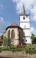
Heilgersdorf, Evang.-Luth. Parish church

Oberelldorf, Catholic branch church St. Nikolaus

Rothenberg, Catholic branch church St. Laurentius


literature
- Johann Kaspar Bundschuh : Seßlach . In: Geographical Statistical-Topographical Lexicon of Franconia . tape 1 : A-egg . Verlag der Stettinische Buchhandlung, Ulm 1799, DNB 790364298 , OCLC 833753073 , Sp. 298-300 ( digitized version ).
- Gertrud Frerichs: Sesslach and its districts - as it used to be . Horb 1989, ISBN 3-89264-349-0 .
- Roland Günter: Seßlach, a Franconian town in harmony with nature; dedicated to a lovely city and its inhabitants . Self-published, Seßlach 2000.
- Konrad Hartig: Seßlach and its history. Staffelstein 1934.
- Alfred Höhn: Testimonies to the history of Sesslach in the Middle Ages. Coburg 1985.
- Gem of the Coburg region - 650 years of the city of Seßlach (special issue of the Neue Presse Coburg). Coburg 1985.
- Stefan Nöth: The city books of Seßlach from the years 1485 and 1550 . Lichtenfels 2005, ISBN 3-87735-181-6 .
- Pleikard Joseph Stumpf : Seßlach . In: Bavaria: a geographical-statistical-historical handbook of the kingdom; for the Bavarian people . Second part. Munich 1853, p. 636-637 ( digitized version ).
Web links
- Homepage of the city of Seßlach
- Entry on the coat of arms of Seßlach in the database of the House of Bavarian History
- Seßlach: Official statistics of the LfStat (PDF, 1.66 MB)
Individual evidence
- ↑ "Data 2" sheet, Statistical Report A1200C 202041 Population of the municipalities, districts and administrative districts 1st quarter 2020 (population based on the 2011 census) ( help ).
- ↑ www.sesslach.de ( Memento of the original from March 24, 2016 in the Internet Archive ) Info: The archive link was inserted automatically and has not yet been checked. Please check the original and archive link according to the instructions and then remove this notice.
- ↑ www.sesslach.de ( Memento of the original from March 24, 2016 in the Internet Archive ) Info: The archive link was inserted automatically and has not yet been checked. Please check the original and archive link according to the instructions and then remove this notice.
- ↑ Thomas Gunzelmann: The cultural landscape around 1840 . In: Günther Dippold: In the upper Main Valley on the Jura at Rodach and Itz. Self-published by Kreissparkasse Lichtenfels, Lichtenfels 1990, p. 75.
- ↑ Documentation: Medieval leprosories in today's Bavaria, originally in "Die Klapper" 1995, magazine of the Society for Leprosy, accessed August 12, 2017 ( Memento of the original from February 6, 2015 in the Internet Archive ) Info: The archive link was automatically inserted and still Not checked. Please check the original and archive link according to the instructions and then remove this notice.
- ^ Federal Statistical Office (ed.): Historical municipality directory for the Federal Republic of Germany. Name, border and key number changes in municipalities, counties and administrative districts from May 27, 1970 to December 31, 1982 . W. Kohlhammer GmbH, Stuttgart / Mainz 1983, ISBN 3-17-003263-1 , p. 679, 680 .

Maple | Bad Rodach | Dörfles-Esbach | Ebersdorf near Coburg | Great marriage | Grub am Forst | Itzgrund | Lautertal | Meeder | Neustadt bei Coburg | Niederfüllbach | Rödental | Seßlach | Sonnefeld | Untersiemau | Weidhausen near Coburg | Weitramsdorf
Unregulated areas of
Callenberger Forst-West |
Gellnhausen |
Köllnholz
Autenhausen | Bischwind | Dietersdorf | Eckersdorf | Gemünda | Gleismuthhausen | Hattersdorf | Heilgersdorf | Krumbach | Lechenroth | Merlach | Oberelldorf | Rothenberg | Seßlach | Setzelsdorf | Unterelldorf | grasslands