
Haßberge district
| coat of arms | Germany map |
|---|---|

|

Coordinates: 50 ° 4 ′ N , 10 ° 37 ′ E |
| Basic data | |
| State : | Bavaria |
| Administrative region : | Lower Franconia |
| Administrative headquarters : | Hassfurt |
| Area : | 956.38 km 2 |
| Residents: | 84,384 (Dec. 31, 2019) |
| Population density : | 88 inhabitants per km 2 |
| License plate : | HAS, EBN, GEO , HOH |
| Circle key : | 09 6 74 |
| NUTS : | DE267 |
| Circle structure: | 26 municipalities |
| Address of the district administration: |
Am Herrenhof 1 97437 Haßfurt |
| Website : | |
| District Administrator : | Wilhelm Schneider ( CSU ) |
| Location of the district of Haßberge in Bavaria | |
  |
|

The Haßberge district is the easternmost district of the Lower Franconia administrative district in Bavaria . The county seat is Haßfurt . The district is a member of the Nuremberg Metropolitan Region and the Main Franconia Regiopole Region .
geography
location
The district lies between the three regional centers of Schweinfurt in the west, Coburg in the northeast and Bamberg in the southeast. The district got its name from the low mountain range of the Haßberge , which includes the northeastern part of the district. In the west there is a flat Gäu landscape and the Schweinfurt Rhön , the eastern part of which belongs to the Haßberge district. In the south, the Haßberge are bounded by the Main , which crosses the district in an east-west direction. The foothills of the Steigerwald lie south of the Main . Tributaries of the Main are the Nassach from the right , which flows into Haßfurt and further east the Baunach . Its mouth is near Baunach , south of Ebern and north of Bamberg.
Neighboring areas
The district borders clockwise in the north, beginning with the districts of Hildburghausen (in Thuringia ), Coburg , Bamberg , Schweinfurt and Rhön-Grabfeld (all in Bavaria).
history

Regional courts
Before 1800, the area of today's Haßberge district belonged mainly to the Würzburg monastery . The Bamberg Monastery also had a share in the south. The city of Königsberg was an exclave of the Duchy of Saxony-Coburg . There were also numerous goods belonging to the imperial knighthood that were organized in the canton of Baunach. In 1802 the area came under Bavaria, except for the Saxon enclaves. In 1804 the regional courts of Ebern , Gleusdorf (seat moved to Baunach in 1808 ), Haßfurt and Hofheim , and in 1819 the regional court of Eltmann were established . All district courts initially belonged to the Lower Main District (from 1838 Lower Franconia ). In 1806 the area of the former Hochstift Würzburg came to the Grand Duchy of Würzburg . This state was created after the Peace of Pressburg and fell back to Bavaria in 1814. In 1840 the district court of Gleusdorf was renamed after its seat in Baunach.
District Offices
In 1862 the Haßfurt and Eltmann district courts became the Haßfurt district office and the Ebern and Baunach district courts became the Ebern district office. The Hofheim district court was assigned to the Königshofen district office (today Bad Königshofen im Grabfeld ). In 1900, however, Hofheim became the seat of its own district office, which in 1920 after the annexation of the Free State of Coburg to Bavaria was assigned to its exclave Königsberg.
Counties
On January 1, 1939, the designation district was introduced as everywhere else in the German Reich . The district offices became the districts of Ebern, Haßfurt and Hofheim.
Haßberge district
As part of the regional reform , the Haßfurt district was merged on July 1, 1972 with large parts of the Ebern and Hofheim districts in Lower Franconia to form a new district. The municipalities Geusfeld and Wustviel (now part of the municipality of Rauhenebrach ) and Wohnau ( Knetzgau ) were added from the disbanded district of Gerolzhofen , as well as the municipality of Koppenwind (now part of Rauhenebrach) from the district of Bamberg .
This newly formed district was initially called the Haßberg district and was renamed the Haßberge district on May 1, 1973 .
Population development
From 1988 to 2008, the Haßberge district grew by over 5000 inhabitants or around 7%. Since 2001 the trend towards a high of approx. 88,500 inhabitants. In the period from 1988 to 2018, the number of inhabitants in the district rose from 80,595 to 84,599 by 4,004 inhabitants or remained an increase of 5%. The following figures refer to the territorial status on May 25, 1987.
| Population development | ||||||||||||||
|---|---|---|---|---|---|---|---|---|---|---|---|---|---|---|
| year | 1840 | 1900 | 1939 | 1950 | 1961 | 1970 | 1987 | 1991 | 1995 | 2000 | 2005 | 2010 | 2015 | |
| Residents | 53,786 | 54,587 | 58,909 | 82,670 | 77,290 | 81,537 | 80.257 | 84.216 | 87.003 | 88,509 | 87,607 | 85.010 | 84,581 | |
Attractions
In the Middle Ages the spheres of power of the two rival dioceses Bamberg and Würzburg met in the Haßberg Mountains. Both monasteries tried to secure their territories by building numerous castles and a few fortified cities. The Haßberge are therefore called the land of palaces, castles and ruins , which are actually located there in unusual numbers. Lichtenstein Castle (south castle) is still inhabited by the castles . The castles Altenstein , Bramberg , Königsberg , Lichtenstein (Nordburg), Rauheneck (Raueneck), Rotenhan , Schmachtenberg and a few others present themselves as ruins . Numerous castle stables are also hidden in the woods, one of the most interesting is the Teufelsstein near Lichtenstein Castle.
The castles of Birkenfeld , Burgpreppach , Eyrichshof , Gleisenau and Rentweinsdorf should be mentioned of the numerous castles of the local landed gentry .
The former Bamberg and Würzburg district towns of Ebern , Hofheim in Lower Franconia , Zeil am Main , Eltmann and today's district town of Haßfurt offer picturesque cityscapes . A special tourist attraction is the well - preserved half - timbered town of Königsberg in Bavaria , a former Saxon-Coburg exclave . Remains of the former strong city fortifications are well worth seeing, especially in Ebern and Zeil. The Ebern gray tower is one of the highest gate towers in Germany.
The highlight of the medieval sacred architecture in the district is the splendid Gothic choir of the Haßfurt Knights' Chapel (though modified in the 19th century) , with St. Laurentius in Ebern and St. Kilian in Haßfurt, beautiful late Gothic parish churches have been preserved.
The famous Rococo pilgrimage church , Maria Limbach , is near Eltmann . The building was designed by Balthasar Neumann .

Lichtenstein Castle

Eyrichshof Castle

Gleisenau Castle

Koenigsberg in Bavaria

Parish Church of St. Laurentius


politics
District administrators
- July 1, 1972 to April 30, 1990: Walter Keller (CSU)
- May 1, 1990 to April 30, 2014: Rudolf Handwerker (CSU)
- Since May 1, 2014: Wilhelm Schneider (CSU), who prevailed in the runoff election against Bernhard Ruß (SPD) with almost 54% of the vote.
District council
The district council consists of 60 members who are divided between the following parties and groups of voters in the 2014–2020 electoral period (the 2008–2014 composition in brackets):
- CSU 22 (21) seats
- SPD 13 (13) seats
- WG Haßberge - Free voters 10 (9) seats
- Young list 5 (6) seats
- GREEN 4 (3) seats
- FDP / Free Citizens 3 (4) seats
- ÖDP 2 (2) seats
- Left Alliance Haßberge 1 (2) seats
coat of arms
|
|
Blazon : “Above a shield base, divided by black and gold and covered with a green diamond wreath, split by red and gold; in front three sunk silver tips, behind a red armored, right jumping black lion covered with a silver sloping bar. " |
| Founding of the coat of arms: The area of today's Haßberge district was created in 1972 through the merger of the earlier Ebern, Haßfurt and Hofheim i. Ufr. The coat of arms reminds of the earlier, most important rulers in the district until the end of the Old Kingdom in 1803. The three silver tips are known as the Franconian rake and were also part of the coats of arms of the former districts of Ebern, Hofheim and Haßfurt. They are reminiscent of the rule of the Würzburg monastery in the district. The same applies to the lion from the coat of arms of the Bamberg Monastery. It was also part of the former coat of arms of the old districts of Ebern and Haßfurt. The motif in the base of the shield comes from the coat of arms of Saxony. It stands for the former rule of the Duchy of Saxe-Coburg and Gotha over the city of Königsberg, which only came to Bavaria in 1920. |
Economy and Infrastructure
In the Future Atlas 2016 , the district of Haßberge was ranked 249 out of 402 districts, municipal associations and independent cities in Germany, making it one of the regions with a “balanced risk-opportunity mix”.
traffic
Road traffic
The A 70 motorway runs through the district in an east-west direction . The federal highway 26 runs parallel to the A 70 , in the north-south direction the federal highways 279 and 303 cross the district.
Rail transport
In the Main Valley, the state-run Ludwigs-West-Bahn has been running on the Bamberg – Haßfurt – Schweinfurt route since 1852 .
It was only 40 years later that the Bavarian State Railroad opened a branch line from Haßfurt to Hofheim, which also served the Königsberg exclave, which belonged to Saxony-Coburg until 1920.
Other local railways brought connections from Bamberg
- 1895/96 via Ebern to Maroldsweisach and
- 1913 via Kaltenbrunn-Untermerzbach to Dietersdorf.
After shutdowns between 1975 and 1995:
- 1975: Breitengüßbach – Memmelsdorf – Dietersdorf (four kilometers)
- 1988: Ebern – Maroldsweisach (16 kilometers)
- 1995: Haßfurt – Königsberg – Hofheim (Ufr) (15 kilometers)
Only half of the total network remained at 37 kilometers.
The Breitengüßbach – Ebern railway has been integrated into the Greater Nuremberg Transport Association (VGN) since 2010 , and on January 1, 2018, the district fully joined the VGN.
Bus transport
All bus traffic within the district is integrated into the Haßberge transport association . Five bus routes from the district to Bamberg are integrated into the VGN.
Shipping
The federal waterway Main , which has a connection to the Rhine and the Main-Danube Canal , flows through the district .
In the city of Zeil am Main there is a port facility for mainly agricultural goods.
I-Company project
As part of the development of the International University Campus i-Campus of the University of Applied Sciences Würzburg-Schweinfurt , an i-Company is to be set up on a new campus in Schweinfurt in cooperation with the Haßberge district and the IHK Würzburg-Schweinfurt . The cooperation between science and industry is to be promoted by placing selected students in small and medium-sized companies for internships and project work.
Communities
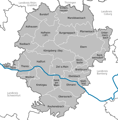

(Residents on December 31, 2019)
|
Other communities
|
|
Denominations
In the district there are communities with a predominantly Catholic and those with a predominantly Protestant population. This plays a role for the public holiday regulation in Bavaria.
Ermershausen and the regional reform
The district became known through the demands of citizens of the village of Ermershausen, which was incorporated into Maroldsweisach, to regain independence as a municipality. The dispute has not always been resolved by peaceful means. After the reorganization of the municipality of Ermershausen (January 1, 1994), calm has returned.
Others
The community-free areas were dissolved on April 1, 2004.
Protected areas
The district has 15 nature reserves , three landscape protection areas , 20 FFH areas and 31 geotopes designated by the Bavarian State Office for the Environment . (As of August 2016). In June 2020 the new Knetzberge-Böhlgrund natural forest was designated.
See also:
- List of nature reserves in the Haßberge district
- List of landscape protection areas in the Haßberge district
- List of FFH areas in the Haßberge district
- List of geotopes in the Haßberge district
License Plate
On August 5, 1974, the district was assigned the HAS distinctive sign , which had been valid for the Haßfurt district since July 1, 1956 . It is still issued today.
Until the 1990s, vehicles from the old districts received special identification numbers:
| area | Letters | numbers |
|---|---|---|
| Haßfurt district | A to Z | 1 to 999 |
| KA to NZ | ||
| XA to ZZ | ||
| Altkreis Hofheim in Lower Franconia | AA to JZ | |
| Altkreis Ebern | PA to WZ |
Since April 1, 2014, the distinguishing marks EBN (Ebern), GEO (Gerolzhofen) and HOH (Hofheim in Unterfranken) have been available again due to the license plate liberalization .
Web links
- Official website of the district of Haßberge
- Haßberge district . In: Bayern-Infos.de
- Haßberge district . In: Bayern-im-Web.de
- Literature from and about the district of Haßberge in the catalog of the German National Library
- Entry on the coat of arms of the Haßberge district in the database of the House of Bavarian History
Individual evidence
- ↑ "Data 2" sheet, Statistical Report A1200C 202041 Population of the municipalities, districts and administrative districts 1st quarter 2020 (population based on the 2011 census) ( help ).
- ^ Wilhelm Volkert (ed.): Handbook of Bavarian offices, communities and courts 1799–1980 . CH Beck, Munich 1983, ISBN 3-406-09669-7 , p. 97 .
- ↑ Entry on the coat of arms of the Haßberge district in the database of the House of Bavarian History , accessed on September 5, 2017 .
- ↑ Future Atlas 2016. (No longer available online.) Archived from the original on October 2, 2017 ; accessed on March 23, 2018 . Info: The archive link was inserted automatically and has not yet been checked. Please check the original and archive link according to the instructions and then remove this notice.
- ↑ VGN is expanded to include the Haßberge district. Bayerischer Rundfunk, January 11, 2018, archived from the original on June 14, 2018 .
- ^ Economy in Mainfranken: The i-Dreiklang of the FHWS , March 2014, pp. 28–29
- ↑ "Data 2" sheet, Statistical Report A1200C 202041 Population of the municipalities, districts and administrative districts 1st quarter 2020 (population based on the 2011 census) ( help ).
- ↑ Bavarian State Statistical Office: Bavarian Municipalities (…) ( Memento of the original from May 20, 2011 in the Internet Archive ) Info: The archive link was inserted automatically and has not yet been checked. Please check the original and archive link according to the instructions and then remove this notice.
- ↑ "Knetzberge-Böhlgrund" natural forest. Retrieved June 25, 2020 .

Independent cities: Amberg | Ansbach | Bamberg | Bayreuth | Coburg | Erlangen | Fürth | Yard | Nuremberg | Schwabach | Willows in the Upper Palatinate
Districts: District of Amberg-Sulzbach | District of Ansbach | Bamberg district | Bayreuth district | District of Coburg | District of Erlangen-Höchstadt | Forchheim district | Fürth district | District of Haßberge | District of Kitzingen | District of Kronach | District of Kulmbach | District of Lichtenfels | District of Neumarkt idOPf. | District Neustadt adAisch-Bad Windsheim | District Neustadt ad Waldnaab | District of Nürnberger Land | District of Roth | District of Sonneberg | District of Tirschenreuth | Weißenburg-Gunzenhausen district | District of Wunsiedel in the Fichtel Mountains
Districts:
Aichach-Friedberg |
Altötting |
Amberg-Sulzbach |
Ansbach |
Aschaffenburg |
Augsburg |
Bad Kissingen |
Bad Toelz-Wolfratshausen |
Bamberg |
Bayreuth |
Berchtesgadener Land |
Cham |
Coburg |
Dachau |
Deggendorf |
Dillingen on the Danube |
Dingolfing-Landau |
Danube Ries |
Ebersberg |
Eichstätt |
Erding |
Erlangen-Höchstadt |
Forchheim |
Freising |
Freyung-Grafenau |
Fürstenfeldbruck |
Fürth |
Garmisch-Partenkirchen |
Gunzburg |
Hatred Mountains |
Yard |
Kelheim |
Kitzingen |
Kronach |
Kulmbach |
Landsberg am Lech |
Landshut |
Lichtenfels |
Lindau (Lake Constance) |
Main-Spessart |
Miesbach |
Miltenberg |
Mühldorf am Inn |
Munich |
Neuburg-Schrobenhausen |
Neumarkt in the Upper Palatinate |
Neustadt an der Aisch-Bad Windsheim |
Neustadt an der Waldnaab |
Neu-Ulm |
Nuremberg Country |
Oberallgäu |
Ostallgäu |
Passau |
Pfaffenhofen an der Ilm |
Rain |
Regensburg |
Rhön-Grabfeld |
Rosenheim |
Roth |
Rottal-Inn |
Schwandorf |
Schweinfurt |
Starnberg |
Straubing Arch |
Tirschenreuth |
Traunstein |
Unterallgäu |
Weilheim-Schongau |
Weißenburg-Gunzenhausen |
Wunsiedel in the Fichtel Mountains |
Wurzburg
Independent cities:
Amberg |
Ansbach |
Aschaffenburg |
Augsburg |
Bamberg |
Bayreuth |
Coburg |
Erlangen |
Fürth |
Hof (Saale) |
Ingolstadt |
Kaufbeuren |
Kempten (Allgäu) |
Landshut |
Memmingen |
Munich |
Nuremberg |
Passau |
Regensburg |
Rosenheim |
Schwabach |
Schweinfurt |
Straubing |
Willows in the Upper Palatinate |
Wurzburg