
Ermershausen
| coat of arms | Germany map | |
|---|---|---|

|
Coordinates: 50 ° 12 ' N , 10 ° 38' E |
|
| Basic data | ||
| State : | Bavaria | |
| Administrative region : | Lower Franconia | |
| County : | Hatred Mountains | |
| Management Community : | Hofheim in Lower Franconia | |
| Height : | 339 m above sea level NHN | |
| Area : | 9.21 km 2 | |
| Residents: | 554 (Dec. 31, 2019) | |
| Population density : | 60 inhabitants per km 2 | |
| Postal code : | 96126 | |
| Area code : | 09532 | |
| License plate : | HAS, EBN, GEO , HOH | |
| Community key : | 09 6 74 223 | |
| Community structure: | 3 districts | |
| Association administration address: | Obere Sennigstrasse 4 97461 Hofheim i.UFr. |
|
| Website : | ||
| Mayor : | Günter Pfeiffer (Free Voters Ermershausen) | |
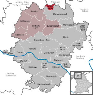
| Location of the municipality of Ermershausen in the Haßberge district | ||
  |
||


Ermershausen in the Haßberge district is the smallest municipality in Lower Franconia .
Nationwide publicity as "the rebel village" reached Ermershausen in 1978 when it refused to be incorporated into Maroldsweisach - initially unsuccessfully.
geography
Geographical location
The community is located in the Haßberge Nature Park . The place borders directly on the Free State of Thuringia ( Schweickershausen in the Hildburghausen district ).
The eight kilometer long Ermetz brook flows through Ermershausen . This rises in the Au north of the village in the border area with Thuringia and flows into the Baunach near Sulzbach .
Neighboring communities
Neighboring communities are (starting from the north in a clockwise direction): Schweickershausen , Maroldsweisach and Sulzdorf an der Lederhecke . The federal road 279 runs through Ermershausen as the main road.
Community structure
The three parts of the community are:
- Ermershausen
- Dutch mill
- Weidachsmühle
history
Until the 19th century
Ermershausen was first documented in 1049 as Ermannshuson in Helendungero marca , d. H. in the Hellinger mark. During the Thirty Years War the place was devastated several times. The Lords of Hutten lived in Birkenfeld from 1475 until they died out in 1783 , and owned both Ermershausen and Birkenfeld. In 1814, Ermershausen fell to Bavaria . 1818 was the municipality Ermershausen. In 1830 a Jewish cemetery was built in Ermershausen .
Struggle for independence
The place achieved some notoriety as the Rebel Village in 1978 . The residents vehemently opposed integration into the municipality of Maroldsweisach through the municipal reform . This culminated in the occupation of the town hall and the erection of barricades by citizens of Ermershausen with the aim of preventing the relocation of the municipal administration to Maroldsweisach. A large number of citizens threatened to cross over to the territory of the GDR and moved to the nearby border, where already opened border gates were waiting for the citizens.
The village was finally by several squadrons of riot police stormed early on May 19, 1978 at three o'clock and cleared the town hall. The incorporation was completed on May 1, 1978. Subsequently, the Ermershäuser fought for their "freedom" for 15 years. To this end, they declared May 15th a general day of remembrance, on which they sounded the "freedom bell" at the town hall at night. The residents of the village complained that it was not furniture or files that had been taken from them that night, but the respect for the state. Since January 1st 1994, however, Ermershausen has been independent again, the state had declared the incorporation "failed" and thus one of the smallest independent municipalities in Bavaria. The withdrawal of the incorporation was achieved u. a. also because the then CSU district councilor Sebastian von Rotenhan - and former CSU member of the state parliament - was able to recruit 278 new members for the CSU overnight in order to be able to build up the pressure within the party accordingly.
Incorporations
On July 1, 1973, the Birkenfeld market and the community of Dippach were incorporated. Both districts were reclassified on May 1, 1978 on the occasion of the incorporation of Ermershausen to Maroldsweisach. When Ermershausen became independent again on January 1, 1994, Birkenfeld and Dippach stayed with Maroldsweisach.
politics
The community is a member of the administrative community Hofheim in Lower Franconia .
Municipal council
The municipality council of Ermershausen has 9 members including the part-time mayor.
| Free voters | Ermershausen citizens list | total | |
| 2014 | 5 | 4th | 9 seats |
| 2008 | 3 | 6th | 9 seats |
mayor
Mayor is Günter Pfeiffer (Free Voters). On May 1, 2014, he succeeded Werner Döhler (Ermershauser Bürgerliste) and won against Theo Vey (Ermershauser Bürgerliste) with around 69% of the vote. On March 15, 2020, he was elected for a further six years without an opponent with 96.2% of the vote.

coat of arms
|
|
Blazon : "Two golden diagonal bars in red covered by a black bell placed at an angle to the left" |
Monuments
Architectural monuments
Soil monuments
Sons and daughters of the church
- Hermann Dietzfelbinger (1908–1984), former Bavarian regional bishop of the ELKB .
- Narcissus Ach (1871-1946), German psychologist
Web links
Individual evidence
- ↑ "Data 2" sheet, Statistical Report A1200C 202041 Population of the municipalities, districts and administrative districts 1st quarter 2020 (population based on the 2011 census) ( help ).
- ↑ BayernPortal> municipality of Ermershausen. Bavarian State Ministry for Digital, accessed on July 3, 2020 .
- ↑ Numbers, data, facts. VG Hofheim i. UFr., Accessed on July 3, 2020 .
- ↑ http://www.bayerische-landesbibliothek-online.de/orte/ortssuche_action.html ? Anzeige=voll&modus=automat&tempus=+20111024/195657&attr=OBJ&val= 46313
- ↑ Bavaria 2- Time for Bavaria: The rebels of Ermershausen from May 19, 2018
- ↑ Martin Reischke: The rebel village Ermershausen. In: Deutschlandradio Kultur. January 2, 2009. Retrieved October 28, 2012 .
- ↑ Olaf Przybilla: The vehemence of the resistance was provoked by the state town hall tower. - When the police storm the town hall. In: Süddeutsche, edition of August 26, 2019, p. R13
- ↑ a b Federal Statistical Office (ed.): Historical municipality register for the Federal Republic of Germany. Name, border and key number changes in municipalities, counties and administrative districts from May 27, 1970 to December 31, 1982 . W. Kohlhammer GmbH, Stuttgart / Mainz 1983, ISBN 3-17-003263-1 , p. 758 and 760 .
- ↑ StBA Area: changes from 01.01. until December 31, 1994
- ↑ Entry on the Ermershausen coat of arms in the database of the House of Bavarian History

Aidhausen | Breitbrunn | Bundorf | Burgpreppach | Ebelsbach | Boars | Eltmann | Ermershausen | Gädheim | Hassfurt | Hofheim in Lower Franconia | Kirchlauter | Knetzgau | Königsberg in Bavaria | Maroldsweisach | Oberaurach | Pfarrweisach | Rauhenebrach | Rentweinsdorf | Riedbach | Sand am Main | Stettfeld | Theres | Untermerzbach | Wonfurt | Zeil am Main