
Maroldsweisach
| coat of arms | Germany map | |
|---|---|---|

|
Coordinates: 50 ° 12 ' N , 10 ° 40' E |
|
| Basic data | ||
| State : | Bavaria | |
| Administrative region : | Lower Franconia | |
| County : | Hatred Mountains | |
| Height : | 334 m above sea level NHN | |
| Area : | 71.87 km 2 | |
| Residents: | 3265 (Dec. 31, 2019) | |
| Population density : | 45 inhabitants per km 2 | |
| Postal code : | 96126 | |
| Area code : | 09532 | |
| License plate : | HAS, EBN, GEO , HOH | |
| Community key : | 09 6 74 171 | |
| LOCODE : | DE MWH | |
| Market structure: | 28 districts | |
Market administration address : |
Main street 24 96126 Maroldsweisach |
|
| Website : | ||
| Mayor : | Wolfram Thein ( SPD ) | |
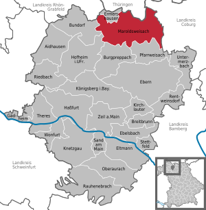
| Location of the Maroldsweisach market in the Haßberge district | ||
  |
||

Maroldsweisach is a market in the Lower Franconian district of Haßberge in Bavaria .
geography
Geographical location
The community is located in the Main-Rhön region on the edge of the Haßberge Nature Park , at the foot of the Zeilberg .
Community structure
Maroldsweisach consists of 17 districts (population in brackets, as of December 31, 2008):
|
|
|
Neighboring communities
Neighboring communities are, starting from the north and clockwise: Schweickershausen , Heldburg (Thuringia), Seßlach (Upper Franconia), Pfarrweisach , Burgpreppach , Hofheim in Lower Franconia , Bundorf , Sulzdorf an der Lederhecke and Ermershausen .
history
Until the church is planted
The first reference to the place was in a document from 1118, according to which a Bamberg canon Qudalrich gave his estate "Wisaha" with all accessories to the Michelsberg monastery in Bamberg. The name “Maroldswisach” appears for the first time in a fief book from 1303 to 1313. At the beginning of the 15th century, the lords of Stein zu Altenstein began to rule the village . Maroldsweisach after that was from 1768 the seat of the same manor it the Baron de Horneck of Weinheim, the 1806 Grand Duchy of Würzburg of Archduke Ferdinand of Tuscany mediated was. In 1814 it fell to Bavaria together with the Grand Duchy .
Special case in Ermershausen
Maroldsweisach achieved some notoriety in 1978 through the decreed incorporation of Ermershausen as part of the regional reform in Bavaria , which vehemently opposed. This culminated in the occupation of the town hall of Ermershausen and the erection of barricades by the citizens to prevent the relocation of the municipal administration to Maroldsweisach. The village was eventually stormed by hundreds of riot police and the town hall was evacuated. The incorporation was completed on May 1, 1978. Since January 1st, 1994, Ermershausen has been independent again.
Religions
75% of the population are Protestant , around 25% Roman Catholic .
Incorporations
On July 1, 1971, the previously independent communities of Allertshausen and Marbach were incorporated. Gückelhirn was added on July 1, 1975. Altenstein followed on January 1, 1976, Pfaffendorf on June 1, 1976. Part of the municipality of Burgpreppach, which had around 50 inhabitants at the time, was reclassified on June 1, 1976. Ditterswind, Hafenpreppach and Wasmuthhausen lost their independence on January 1, 1978 and were incorporated into the Maroldsweisach market. The series of incorporations was completed with the incorporation of Dürrenried, Eckartshausen, Ermershausen (with the market Birkenfeld incorporated on July 1, 1973 and the former municipality of Dippach) and Voccawind on May 1, 1978.
Outsourcing
On January 1, 1994, the district of Ermershausen was spun off from the Maroldsweisach market. Birkenfeld and Dippach remained in the market.
Population development
- 1961: 3939 inhabitants without Ermershausen, 4875 with Ermershausen
- 1970: 3868 inhabitants without Ermershausen, 4758 with Ermershausen
- 1987: 3956 inhabitants without Ermershausen
- 1991: 4749 inhabitants with Ermershausen
- 1995: 4046 inhabitants
- 2000: 3929 inhabitants
- 2005: 3765 inhabitants
- 2010: 3574 inhabitants
- 2015: 3339 inhabitants
politics
mayor
Mayor is Wolfram Thein (SPD), who won the elections on March 16, 2014 with a majority of only 43 votes (51.01 to 48.99 percent) against his competitor Harald Deringer (CSU). In 2020, Thein was confirmed in office for another six years with a majority of 53.05% of the votes against Heidi Müller-Gärtner (CSU). His predecessors were Wilhelm Schneider (CSU), who was elected district administrator in 2014, and Werner Thein (SPD) until 2002.
Market council
| CSU | SPD | FWG | Young Christian Union | Young citizens | total | |
| 2020 | 5 | 5 | 2 | 2 | 2 | 16 seats |
| 2014 | 5 | 6th | 2 | 2 | 1 | 16 seats |
| 2008 | 6th | 6th | 1 | 2 | 1 | 16 seats |
coat of arms
"Under the red head of the corrugated shield, there are three golden hammers in silver above a green three-mountain and a black ladder that is inclined to the left".
Economy and Infrastructure
In 1998, according to official statistics, there were 14 employees in the field of agriculture and forestry, 459 in manufacturing and 140 in the field of trade and transport. In other economic areas, 380 people were employed at the place of work subject to social security contributions. There were a total of 1,397 employees at the place of residence subject to social security contributions. There were two companies in manufacturing and ten in construction. In addition, in 1999 there were 118 farms with an agricultural area of 3,015 hectares, of which 2,420 hectares were arable land and 583 hectares were permanent green space.
traffic
The Reichsautobahn was supposed to lead from Eisenach to Bamberg via Maroldsweisach (see route 85 ). This motorway was part of the basic network as early as 1934 as a section of the Reichsautobahn from Munich to Hamburg . The construction of the motorway was already under way in the Schmalkalden area and was discontinued after the start of the Second World War .
The national highway 279 leads the main road through Maroldsweisach.
There was also the end point of the Breitengüßbach – Maroldsweisach railway line . In 1988 passenger traffic was discontinued, in 2001 the final shutdown and then the dismantling of the Ebern- Maroldsweisach section.
education


In 2013 the following institutions existed:
- A day-care facility with 112 places and 109 children
- Two primary schools with 17 teachers and 265 students
- An elementary school for special needs education with 30 teachers and 146 students
Breweries
Today there is only the Hartleb brewery in Maroldsweisach in the area of the municipality .
Architectural monuments
- Old Castle (Altenstein)
- Altenstein Castle
- Ditterswind Castle
- Hafenpreppach Castle
- Maroldsweisach Castle
- Pfaffendorf Castle
- Pfaffendorf village church
- Birkenfeld Castle
Personalities
Honorary citizen
- Johannes Rau (1931–2006), former Federal President D.
Sons and daughters of the church
- Erdmann Rudolf Fischer (1687–1776), Lutheran theologian
- Christoph Ernst Luthardt (1823–1902), Lutheran theologian
- Bertha Keyser (1868–1964) dedicated her life to humanitarian aid
- Hans Kääb (1890–1982), lawyer and administrative officer
- Rudolf Berthold (1891–1920), successful fighter pilot in World War I and holder of the order Pour le Mérite
- Franz Schubert (1905–1992), politician
- Andrea Thema (* 1957), artist
Personalities who have worked on site
- Carl Otto Deuster (1800–1877), landowner and politician, Deuster acquired the Ditterswind estate in the 1840s, which today belongs to Maroldsweisach
- Carl Oskar von Deuster (1835–1904), landowner and politician, Deuster and his brothers acquired the Greßelgrund and Wasmuthhausen estates, which are now part of Maroldsweisach, in the 1880s
- Friedrich Christian von Deuster (1861–1945), landowner and politician, Deuster carried on the goods acquired from his ancestors
- Susanne Kastner (* 1946), German politician (SPD)
Individual evidence
- ↑ "Data 2" sheet, Statistical Report A1200C 202041 Population of the municipalities, districts and administrative districts 1st quarter 2020 (population based on the 2011 census) ( help ).
- ↑ http://www.bayerische-landesbibliothek-online.de/orte/ortssuche_action.html ? Anzeige=voll&modus=automat&tempus=+20111025/124357&attr=OBJ&val= 1638
- ↑ a b c d Federal Statistical Office (Hrsg.): Historical municipality register for the Federal Republic of Germany. Name, border and key number changes in municipalities, counties and administrative districts from May 27, 1970 to December 31, 1982 . W. Kohlhammer, Stuttgart / Mainz 1983, ISBN 3-17-003263-1 , p. 758-760 .
- ↑ StBA Area: changes from 01.01. until December 31, 1994
- ^ Wilhelm Volkert (ed.): Handbook of Bavarian offices, communities and courts 1799–1980 . C. H. Beck'sche Verlagsbuchhandlung, Munich 1983, ISBN 3-406-09669-7 , p. 453 .
- ↑ [1] ( Page no longer available , search in web archives ) Info: The link was automatically marked as defective. Please check the link according to the instructions and then remove this notice.
Web links
- Entry on the coat of arms of Maroldsweisach in the database of the House of Bavarian History

Aidhausen | Breitbrunn | Bundorf | Burgpreppach | Ebelsbach | Boars | Eltmann | Ermershausen | Gädheim | Hassfurt | Hofheim in Lower Franconia | Kirchlauter | Knetzgau | Königsberg in Bavaria | Maroldsweisach | Oberaurach | Pfarrweisach | Rauhenebrach | Rentweinsdorf | Riedbach | Sand am Main | Stettfeld | Theres | Untermerzbach | Wonfurt | Zeil am Main