
Aidhausen
| coat of arms | Germany map | |
|---|---|---|

|
Coordinates: 50 ° 9 ′ N , 10 ° 26 ′ E |
|
| Basic data | ||
| State : | Bavaria | |
| Administrative region : | Lower Franconia | |
| County : | Hatred Mountains | |
| Management Community : | Hofheim in Lower Franconia | |
| Height : | 292 m above sea level NHN | |
| Area : | 37.3 km 2 | |
| Residents: | 1699 (Dec. 31, 2019) | |
| Population density : | 46 inhabitants per km 2 | |
| Postal code : | 97491 | |
| Primaries : | 09523, 09526 | |
| License plate : | HAS, EBN, GEO , HOH | |
| Community key : | 09 6 74 111 | |
| LOCODE : | DE AIE | |
| Community structure: | 11 districts | |
| Association administration address: | Obere Sennigstr. 4 97461 Hofheim i.UFr. |
|
| Website : | ||
| Mayor : | Dieter Möhring ( Free Voters ) | |
| Location of the community of Aidhausen in the Haßberge district | ||
  |
||

Aidhausen is a municipality in the Lower Franconian district of Haßberge and a member of the administrative community Hofheim in Lower Franconia .
geography
Geographical location
The municipality is located in the Main-Rhön ( Haßgau ) region. The southern forests of the municipality are in the Schweinfurt Rhön .
Community structure
There are eleven officially named parts of the municipality with 1905 inhabitants (status: population update July 2, 2012):
|
|
The districts of Aidhausen, Friesenhausen, Happertshausen, Kerbfeld and Nassach have existed since the municipal reform .
Neighboring communities
Neighboring communities are (starting from the north clockwise): Bundorf , Hofheim in Unterfranken , Riedbach , Schonungen and Stadtlauringen .
history
Until the church is planted
Aidhausen was first mentioned in a document in 824 and was an office of the Hochstift Würzburg , which belonged to the Franconian Empire from 1500 . After secularization in favor of Bavaria in 1805, it was given to Archduke Ferdinand of Tuscany to form the Grand Duchy of Würzburg , before it returned to Bavaria with the Treaties of Paris in 1814. In the course of the administrative reforms in Bavaria , today's municipality was created with the municipal edict of 1818 .
20th century
Until 1942, when the last Jewish families were deported for extermination, there was a Jewish community in the village . Their synagogue was desecrated during the November pogrom in 1938 , the building was preserved and has served as an apartment and workshop ever since. A memorial stone on the green area opposite the former church commemorates this event.
Sub-locations
Happertshausen is a former royal village and is one of the oldest settlements in the Haßgau . Friesenhausen is characterized by its imposing Renaissance castle and church. The parish village of Kerbfeld has a baroque church from 1705. Nassach was a Saxon exclave . In 1353 it fell to the Sonnefeld monastery and after its dissolution in 1525 remained part of the Sonnefeld monastery office taken over by Saxe-Coburg-Gotha . Together with Sachsen-Coburg , Nassach came to Bavaria in 1920. Rottenstein is the smallest district that was attached to Friesenhausen before the regional reform.
Incorporations
On July 1, 1974, the previously independent municipality of Nassach was incorporated. Happertshausen, Kerbfeld and the Friesenhausen market were added on May 1, 1978.
Population development
- 1961: 2010 inhabitants
- 1970: 2067 inhabitants
- 1987: 1911 inhabitants
- 1991: 1948 inhabitants
- 1995: 1959 inhabitants
- 2000: 1952 inhabitants
- 2005: 1926 inhabitants
- 2010: 1792 inhabitants
- 2015: 1787 inhabitants

Aidhausen from the southeast

Friesenhausen from the east

Happertshausen and Aidhausen from the east

Hassberge near Kerbfeld
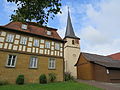
Rectory and church in Kerbfeld

Kerbfeld from the east


politics
Municipal council
The municipal council has 12 members:
| CSU / Free Voters | CSU | Free voters | Boy list | total | |
| 2020 | 12 | - | - | - | 12 seats |
| 2014 | - | 5 | 7th | - | 12 seats |
| 2008 | - | 3 | 7th | 2 | 12 seats |
mayor
Mayor is Dieter Möhring (Free Voters). He was elected to succeed Hildegard Bayer (CSU) in 2002, re-elected in 2008 with a good 92% unopposed and won against Ruth Schwappach (CSU) in 2014 with around 80% of the vote. In 2020 he was re-elected without an opponent with 91.5% of the valid votes.
Architectural monuments
Economy and Infrastructure
Economy including agriculture and forestry
The municipal tax revenue amounted to the equivalent of 610,000 euros in 1999, of which 52,000 euros (net) were trade tax revenue.
In 1998 there were no employees in the field of agriculture and forestry, 96 in the manufacturing sector and no employees in the field of trade and transport at the place of work. In other economic areas, 26 people were employed at the place of work subject to social security contributions. There were a total of 632 employees at the place of residence subject to social security contributions. There were none in manufacturing and four in the construction industry. In addition, in 1999 there were 110 farms with an agricultural area of 2614 hectares. Of this, 2,169 hectares were arable land and 438 hectares were permanent green space.
education
In 1999 there was a kindergarten with 125 places and 95 children.
Sons and daughters of the church
- Clemens Fuhl (* 1874; † 1935), Prior General of the Augustinian Hermits
- Richard Gehrig (* 1897; † unknown), German politician (NSDAP)
- Luise Brunner (* 1908; † unknown), SS entourage in Auschwitz and Ravensbrück concentration camps
- Heribert Brander (* 1926), Catholic clergyman, vicar general of the Diocese of Würzburg
- Paul Röhner (* 1927; † 2014), German politician (CSU) and Lord Mayor of Bamberg (1982–1994)
- Gernot Brühler (* 1953), presiding judge at the Federal Labor Court
Web links
- Aidhausen website
- Aidhausen: Official statistics of the LfStat
- Entry on the coat of arms of Aidhausen in the database of the House of Bavarian History
Individual evidence
- ↑ "Data 2" sheet, Statistical Report A1200C 202041 Population of the municipalities, districts and administrative districts 1st quarter 2020 (population based on the 2011 census) ( help ).
- ^ Aidhausen community: local council. Retrieved May 23, 2020 .
- ↑ Bavarian State Library Online (BLO)
- ↑ Memorial sites for the victims of National Socialism. A documentation, volume 1. Federal Agency for Civic Education, Bonn 1995, ISBN 3-89331-208-0 , p. 112
- ↑ a b c Federal Statistical Office (ed.): Historical municipality directory for the Federal Republic of Germany. Name, border and key number changes in municipalities, counties and administrative districts from May 27, 1970 to December 31, 1982 . W. Kohlhammer GmbH, Stuttgart / Mainz 1983, ISBN 3-17-003263-1 , p. 759 and 760 .
- ↑ Results of the 2020 local elections

Aidhausen | Breitbrunn | Bundorf | Burgpreppach | Ebelsbach | Boars | Eltmann | Ermershausen | Gädheim | Hassfurt | Hofheim in Lower Franconia | Kirchlauter | Knetzgau | Königsberg in Bavaria | Maroldsweisach | Oberaurach | Pfarrweisach | Rauhenebrach | Rentweinsdorf | Riedbach | Sand am Main | Stettfeld | Theres | Untermerzbach | Wonfurt | Zeil am Main