
Cormoret
| Cormoret | |
|---|---|
 |
|
| State : |
|
| Canton : |
|
| Administrative district : | Bernese Jura |
| BFS no. : | 0432 |
| Postal code : | 2612 |
| Coordinates : | 571 029 / 224975 |
| Height : | 706 m above sea level M. |
| Height range : | 702–1606 m above sea level M. |
| Area : | 13.48 km² |
| Residents: | 491 (December 31, 2018) |
| Population density : | 36 inhabitants per km² |
| Website: | www.cormoret.ch |
_020.JPG) Cormoret taken from the train |
|
| Location of the municipality | |
  |
|
Cormoret is a municipality in the Bernese Jura administrative district in the canton of Bern in Switzerland .
geography
Cormoret lies at 706 m above sea level. M. , 15 km west-northwest of Biel (linear distance) and 1 km west of the district capital Courtelary. The former street line village extends in the central part of the Jura Long Valley Vallon de Saint-Imier on both sides of the river Schüss ( French: Suze ).
The area of the 13.4 km² municipal area comprises a relatively narrow section of the valley basin of the Vallon de Saint-Imier. The central part is taken by the valley of the Schüss. In the north, the area extends to the anticline of the Montagne du Droit (up to 1268 m above sea level ) and into the depression at Les Breuleux. To the south, Cormoret extends to the height of the Chasseral chain and up to the 1607 m high summit of the Chasseral (highest point in the municipality). At the top of the Chasseral chain, the hard cover rock was broken up and eroded away, creating a northern and a southern ridge over the course of millions of years. In between there is an anticline valley that has already been cleared to the next hard rock layer. This vault forms a third broad ridge between the two outer ridges, the Petit Chasseral ( 1572 m above sea level ). On the wide ridges of the Montagne du Droit and the Chasseral chain, there are extensive Jura high pastures with the typical, mighty spruce trees , either individually or in groups. The heights of Chasseral and Petit Chasseral are already above the regional tree line. In 1997, 3% of the municipal area was in settlements, 44% in forests and woodlands, 52% in agriculture and a little less than 1% was unproductive land.
The hamlet of Mont Crosin , 1177 m above sea level, belongs to Cormoret . M. on the upper southern slope of the Montagne du Droit on the road from Saint-Imier to Tramelan , as well as numerous individual farms that are widely scattered in the valley and on the Jura heights. Neighboring communities of Cormoret are Villeret , Nods and Courtelary in the canton of Bern and Les Breuleux in the canton of Jura .
population
With 491 inhabitants (as of December 31, 2018), Cormoret is one of the medium-sized communities in the Bernese Jura . 86.6% of the residents are French-speaking and 11.7% German-speaking (as of 2000). The population of Cormoret was 478 in 1850 and 746 in 1910. It has decreased significantly since then. Today Cormoret has grown together with the neighboring town of Courtelary.
politics
The voting shares of the parties on the occasion of the 2015 National Council election were: SVP 34.5%, SP 20.3%, GPS 16.8%, BDP 16.3%, FDP 4.5%, EPP 3.8%, PdA 1.4 %, EDU 1.1%, CVP 0.8%, glp 0.3%.
economy
Cormoret was a predominantly agricultural village until the end of the 19th century , but there were also a few mills on the Schüss. From around 1880 the watch industry also gained a foothold in Cormoret and led to an economic boom; the last watch factory was closed in 1983. Today there is a machine factory in the village. Agriculture with cattle breeding and dairy farming , and some arable farming in the lower areas , still play an important role.
traffic
The community has good transport links. It is located on the busy main road from Biel to La Chaux-de-Fonds . On April 30, 1874, the railway line from Biel to Convers was opened with a train station in Cormoret.
history

The first written mention of the village, already under the current name of Cormoret, dates back to 1178. The Saint-Imier monastery owned land in Cormoret. Until 1797 the village belonged to the Erguel lordship , which was subordinate to the Duchy of Basel , although the city of Biel also exerted greater influence at times. A village fire destroyed numerous houses in 1795. From 1797 to 1815, Cormoret belonged to France and was initially part of the Mont-Terrible department , which was linked to the Haut-Rhin department in 1800 . As a result of the decision of the Congress of Vienna , the place came to the canton of Bern in the Courtelary district in 1815 .
Attractions
The oldest building in Cormoret is a working farm with a mill built in 1597. In the center of the village there are numerous characteristic houses and farms from the 17th to 19th centuries that are under monument protection. Cormoret does not have its own church, it belongs to the parish of Courtelary.
photos

CFF / SBB train station

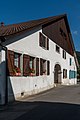
Schoolhouse and municipal administration

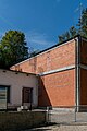
Multipurpose hall
Farmhouse

Farmhouse

Farmhouse
Water intake, Vallon de Saint-Imier


Personalities
- Emile Ganguillet (1818-1894), hydraulic engineer
- Etienne Primault (1904–1984), weapons chief of the air and anti-aircraft troops
Web links
- Official website of the municipality of Cormoret
- Anne Beuchat-Bessire: Cormoret. In: Historical Lexicon of Switzerland .
Individual evidence
- ↑ Permanent resident population from STAT-TAB of the BfS , municipalities see also regional portraits 2020 on bfs.admin.ch, accessed on May 29, 2020
- ^ Results of the municipality of Cormoret. State Chancellery of the Canton of Bern, October 18, 2015, accessed on April 17, 2016 .
Belprahon | Champoz | Corcelles | Corgémont | Cormoret | Cortébert | Court | Courtelary | Crémines | Eschert | Grandval | La Ferrière | La Neuveville | Loveresse | Mont-Tramelan | Moutier | Nods | Orvin | Perrefitte | Péry-La Heutte | Petit-Val | Plateau de Diesse | Rebévelier | Reconvilier | Renan | Roches | Romont | Saicourt | Saint-Imier | Suction | Saules | Scolding (La Scheulte) | Seehof (Elay) | Sonceboz-Sombeval | Sonvilier | Sorvilier | Tavannes | Tramelan | Valbirse | Villeret
Former municipalities: Bévilard | Châtelat | This | La Heutte | Lamboing | Malleray | Monible | Péry | Plagne | Pontenet | Prêles | Sornetan | Souboz | Tramelan lingerie | Tramelan Dessus | Vauffelin
Canton of Bern | Administrative districts of the canton of Bern | Municipalities of the Canton of Bern