
Nods BE
| BE is the abbreviation for the canton of Bern in Switzerland and is used to avoid confusion with other entries of the name Nods . |
| Nods | |
|---|---|
 |
|
| State : |
|
| Canton : |
|
| Administrative district : | Bernese Jura |
| BFS no. : | 0724 |
| Postal code : | 2518 |
| Coordinates : | 572931 / 218316 |
| Height : | 885 m above sea level M. |
| Height range : | 792–1607 m above sea level M. |
| Area : | 26.61 km² |
| Residents: | 765 (December 31, 2018) |
| Population density : | 29 inhabitants per km² |
| Website: | www.nods.ch |
 The village square with the village fountain |
|
| Location of the municipality | |
  |
|
Nods is a municipality in the Bernese Jura administrative district in the canton of Bern in Switzerland . The former German name Nos is no longer used today.
geography

Nods is at 885 m above sea level. M. , 13 km west of Biel (linear distance). The village extends on the lower southern slope of the Chasseral , around 80 m above the plateau of the Montagne de Diesse (German Tessenberg ) above Lake Biel . When the weather is clear, the view extends from Nods over the Swiss Plateau to the Alps .
The area of the 26.7 km² municipal area includes the central section of the flat plateau of the Montagne de Diesse ( 800 m above sea level ) in the south . To the north, the area extends over the wide southern slope of the Jura chain of the Chasseral to its summit, which is 1607 m above sea level. M. represents the highest point of Nods. In the northeast, the municipality includes the syncline valley Les Prés Vaillons , which lies between the chains of the Chasseral and the Mont Sujet . In this area as well as at the height above Les Prés-d'Orvin there are extensive Jura high pastures with the typical mighty spruce trees , which either stand individually or in groups. The southern slope of the Chasseral, which has a slope of around 20-30%, is covered with dense forest. At around 1400 to 1500 m above sea level. M. is the regional tree line, above there are pastures with subalpine flora . In 1997, 3% of the municipal area was in settlements, 53% in forests and woodlands, 44% in agriculture and a little less than 1% was unproductive land.
The hamlets of Les Combes ( 860 m above sea level ) on the southern slope of the Chasseral and La Praye ( 806 m above sea level ) on the Plateau de Diesse as well as numerous individual farms belong to Nods . Neighboring communities of Nods are Plateau de Diesse , Orvin , Corgémont , Cortébert , Courtelary , Cormoret and Villeret in the canton of Bern and Val-de-Ruz and Lignières in the canton of Neuchâtel .
population
| year | 1850 | 1860 | 1870 | 1880 | 1888 | 1900 | 1910 | 1920 | 1930 | 1941 | 1950 | 1960 | 1970 | 1980 | 1990 | 2000 | 2010 |
|---|---|---|---|---|---|---|---|---|---|---|---|---|---|---|---|---|---|
| Residents | 811 | 832 | 885 | 853 | 784 | 738 | 709 | 659 | 609 | 574 | 510 | 473 | 464 | 426 | 516 | 668 | 746 |
With 765 inhabitants (as of December 31, 2018), Nods is one of the medium-sized communities in the Bernese Jura . Of the residents, 85.0% are French-speaking, 12.3% German-speaking and 1.1% Portuguese-speaking (as of 2000). The population was subject to strong fluctuations: While 885 inhabitants were counted in 1870, there were only 426 inhabitants in 1980. Since then, significant growth rates have been recorded again.
politics
The voting shares of the parties in the 2015 National Council election were: SVP 40.1%, SP 24.3%, BDP 8.9%, FDP 8.5%, GPS 7.0%, glp 3.6%, EDU 3.4 %, EVP 2.4%, CVP 0.8%.
economy

Up until the second half of the 20th century, Nods was mainly characterized by agriculture . Since around 1980 the village has gradually developed into a residential community, which led to a marked increase in population. Several new residential areas were built around the village center. Today there are jobs in mechanics and in local trades (including a cheese factory). However, many workers are commuters and work in Biel or in the La Neuveville region .
traffic
The community is located away from the major thoroughfares. Nods is connected to Neuchâtel , La Neuveville and Biel by cantonal roads. A road leads from the village to the Chasseral and further into the Vallon de Saint-Imier . From La Neuveville there is a postbus course to Nods, which also serves the other Bernese communities on the Plateau de Diesse. From 1963 to 1993 a chairlift from Nods to the mountain inn on the Chasseral was in operation.
history

The first documentary mention of Nods took place in 1228. The place belonged to the Counts of Neuchâtel, then the Counts of Neuchâtel-Nidau. The sovereignty was held by the Principality of Basel , which was primarily responsible for judicial and military matters. During the Reformation, Nods stayed with the Catholic faith. The Reformation was only imposed by the city of Bern around 1550 , which prompted some families to emigrate to the Catholic Le Landeron or Cressier . On August 23, 1798, numerous houses fell victim to a village fire. From 1798 to 1815 Nods belonged to France and was initially part of the Mont Terrible department , which was linked to the Haut-Rhin department in 1800 . As a result of the decision of the Congress of Vienna , the place came to the canton of Bern to the district of Erlach in 1815 and to the new district of La Neuveville in 1846 . Since 1988, maintains Nods relations with the eponymous French partner community Nods in the department of Doubs.
In March 2012, a merger project under the name Le Plateau de Diesse between the municipalities of Diesse , Lamboing , Nods and Prêles failed due to the No of the municipality of Nods.
Attractions

The reformed parish church from 1835 was renovated in 1959–1961. It replaced an earlier church from 1639, in the place of which a schoolhouse was built after the inauguration of the new village church. Since 1708 Nods, which was previously dependent on Diesse , has its own parish. In the center of the village is the communal tower ( Tour communale or Tour de Beffroi ), which was first mentioned in 1689. Nods has a picturesque town center with numerous characteristic farmhouses from the 18th and 19th centuries.
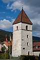
Tour de Beffroi
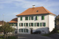
The school house, which stands in the place of the old church


Web links
- Official website of the municipality of Nods (French)
- Frédy Dubois: Nods. In: Historical Lexicon of Switzerland .
Individual evidence
- ↑ Permanent resident population from STAT-TAB of the BfS , municipalities see also regional portraits 2020 on bfs.admin.ch, accessed on May 29, 2020
- ^ Results of the Nods community. State Chancellery of the Canton of Bern, October 18, 2015, accessed on April 17, 2016 .
Belprahon | Champoz | Corcelles | Corgémont | Cormoret | Cortébert | Court | Courtelary | Crémines | Eschert | Grandval | La Ferrière | La Neuveville | Loveresse | Mont-Tramelan | Moutier | Nods | Orvin | Perrefitte | Péry-La Heutte | Petit-Val | Plateau de Diesse | Rebévelier | Reconvilier | Renan | Roches | Romont | Saicourt | Saint-Imier | Suction | Saules | Scolding (La Scheulte) | Seehof (Elay) | Sonceboz-Sombeval | Sonvilier | Sorvilier | Tavannes | Tramelan | Valbirse | Villeret
Former municipalities: Bévilard | Châtelat | This | La Heutte | Lamboing | Malleray | Monible | Péry | Plagne | Pontenet | Prêles | Sornetan | Souboz | Tramelan lingerie | Tramelan Dessus | Vauffelin
Canton of Bern | Administrative districts of the canton of Bern | Municipalities of the Canton of Bern