
Erlach district
| Erlach district | |
|---|---|
 |
|
| Basic data | |
| Country: |
|
| Canton : |
|
| Main town : | Erlach |
| Area : | 84.37 km² |
| Residents: | 10,867 (December 31, 2008) |
| Population density : | 129 inhabitants per km² |
| map | |
 |
|
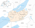
The Erlach district was an administrative unit of the canton of Bern until December 31, 2009 . The administrative district with the main town Erlach comprised twelve communities.
Communities
| Name of the parish | Population (December 31, 2008) |
Area in km² | Inhabitants per km² |
|---|---|---|---|
| Shaking | 592 | 6.61 | 90 |
| Erlach | 1146 | 3.49 | 328 |
| Dark hens | 470 | 3.57 | 132 |
| Gals | 708 | 7.84 | 90 |
| Gampelen | 772 | 10.60 | 73 |
| Ins | 3133 | 23.87 | 131 |
| Lüscherz | 530 | 5.42 | 98 |
| Müntschemier | 1276 | 4.87 | 262 |
| Siselen | 579 | 5.51 | 105 |
| Riding | 412 | 4.74 | 87 |
| Tschugg | 427 | 3.29 | 130 |
| Vinelz | 822 | 4.56 | 180 |
| Total (12) | 10,867 | 84.37 | 129 |
Changes in the community

Municipalities until 1916

Municipalities until 1945
Municipalities until 2009


- 1917: Merger of Brüttelen and Gäserz → Brüttelen
- 1946: Mullen and Tschugg → Tschugg merge
- 2010: Change of district of all 12 municipalities from the Erlach district → Seeland administrative district
Web links
- Hans-Rudolf Egli: Erlach (rule, administrative district). In: Historical Lexicon of Switzerland .
Individual evidence
Aarberg | Aarwangen | Bern | Biel | Büren | Burgdorf | Courtelary | Erlach | Fraubrunnen | Frutigen | Interlaken | Konolfingen | Laupen | Moutier | La Neuveville | Nidau | Lower Simmental | Oberhasli | Obersimmental | Saanen | Schwarzenburg | Juicy | Signau | Tuna | Trachselwald | Cheeks
Canton of Bern | Districts of Switzerland | Municipalities of the Canton of Bern

Four parishes: Bolligen | Vechigen | Stettlen | Muri
Regional courts: Seftigen | Sternenberg | Konolfingen | Zollikofen
Offices: Thun | Zofingen | Aarau | Lenzburg | Brugg | Burgdorf | Büren | Unterseen | Wiedlisbach | Obersimmental | Lower Simmental | Frutigen | Oberhofen | Aigle | Hasli | Trachselwald | Bipp | Aarwangen | Cheeks | Landshut | Lenzburg (Office) | Schenkenberg | Aarberg | Nidau | Erlach | Laupen | Oltigen | Signau | Biberstein | Aarburg | Saanen | Brandis | Interlaken | Königsfelden | Thorberg | Fraubrunnen | Zofingen (pen) | Frienisberg | St. Johannsen | Gottstatt | Buchsee | Sumiswald | Roche (Saline) | Köniz | Kasteln | Hettiswil
Offices in Vaud: Avenches | Moudon | Yverdon | Lausanne | Morges | Nyon | Vevey | Romainmôtier | Oron | Payerne | Bonmont | Aubonne
Common lords with Freiburg: Schwarzenburg | Murten | Grandson | Echallens
Common federal dominions: Baden | Thurgau | Free offices | Rhine Valley | Sargans | Locarno | Lugano | Mendrisio | Valle Maggia
Offices and services in the city of Bern: Bauamt | Salt Directorate | Mushafen | Pen | Corn Office | Big hospital | Inselspital