Moutier district
| Moutier district | |
|---|---|
| Basic data | |
| Country: |
|
| Canton : |
|
| Main town : | Moutier |
| Area : | 216.47 km² |
| Residents: | 23,327 (December 31, 2013) |
| Population density : | 108 inhabitants per km² |
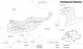
| map | |
The District de Moutier (German: District Moutier ) was an administrative unit of the canton of Bern until December 31, 2009 . The administrative district with the capital Moutier is French-speaking and comprised 26 communities with 23,327 inhabitants (as of December 31, 2013) on 216.47 km²:
Communities
| Name of the parish | Population (December 31, 2013) |
Area in km² | Inhabitants per km² |
|---|---|---|---|
| Belprahon | 33 | 3.82 | 9 |
| Bévilard | 1730 | 5.63 | 307 |
| Champoz | 157 | 7.17 | 22nd |
| Chatelat | 105 | 4.09 | 26th |
| Corcelles (BE) | 212 | 6.79 | 31 |
| Court | 1432 | 24.61 | 58 |
| Crémines | 539 | 9.48 | 57 |
| Eschert | 364 | 6.58 | 55 |
| Grandval | 362 | 8.25 | 44 |
| Loveresse | 321 | 4.69 | 68 |
| Malleray | 1972 | 10.35 | 191 |
| Monible | 36 | 3.39 | 11 |
| Moutier | 7608 | 19.61 | 388 |
| Perrefitte | 456 | 8.57 | 53 |
| Pontenet | 217 | 2.74 | 79 |
| Rebévelier | 45 | 3.55 | 13 |
| Reconvilier | 2284 | 8.25 | 277 |
| Roches (BE) | 211 | 8.97 | 24 |
| Saicourt | 609 | 13.77 | 44 |
| Saules (BE) | 156 | 4.25 | 37 |
| Scolding (La Scheulte) | 40 | 5.56 | 7th |
| Seehof (Elay) | 69 | 8.42 | 8th |
| Sornetan | 139 | 5.62 | 25th |
| Sorvilier | 255 | 6.90 | 37 |
| Souboz | 131 | 10.63 | 12 |
| Tavannes | 3563 | 14.78 | 241 |
| Total (26) | 23,327 | 216.47 | 108 |
Changes in the community
- 1914: Change of name from La Scheulte → Schelten
- 1976: Change of district of Châtillon , Corban , Courchapoix , Courrendlin , Mervelier and Rossemaison from the Moutier district to the Delsberg district
- 1976: District change of Lajoux and Les Genevez from the Moutier district → Freiberge district
- 1976: District exchange of Rebévelier from District Delémont → District Moutier
- July 1, 1996: Vellerat changed canton from the Moutier district in the canton of Bern → Delsberg district in the canton of Jura
- 2010: District change of all 26 municipalities from the Moutier district → Bernese Jura administrative district
Web links
Commons : Moutier district - collection of images, videos and audio files
- Stéphanie Lachat: Moutier (district). In: Historical Lexicon of Switzerland .


