
District of Wangen
| District of Wangen | |
|---|---|
 |
|
| Basic data | |
| Country: |
|
| Canton : |
|
| Main town : | Cheeks on the Aare |
| Area : | 152.05 km² |
| Residents: | 26,853 (December 31, 2008) |
| Population density : | 177 inhabitants per km² |
| map | |
 |
|
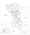
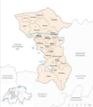
The district of Wangen was an administrative unit of the Canton of Bern until December 31, 2009 . The administrative district with its main town Wangen an der Aare comprised 23 communities with 26,853 inhabitants on 152.05 km² (as of December 31, 2008):
Communities
| Name of the parish | Population (December 31, 2008) |
Area in km² | Inhabitants per km² |
|---|---|---|---|
| Attiswil | 1316 | 7.65 | 172 |
| Berken | 49 | 1.39 | 35 |
| Bettenhausen | 480 | 1.94 | 247 |
| Bollodingen | 223 | 2.00 | 112 |
| Ferns | 201 | 3.68 | 55 |
| dig | 302 | 3.16 | 96 |
| Heimenhausen | 423 | 5.84 | 72 |
| Hermiswil | 97 | 23.40 | 4th |
| Herzogenbuchsee | 6525 | 9.82 | 664 |
| Inkwil | 637 | 3.38 | 188 |
| Niederbipp | 3942 | 17.31 | 228 |
| Niederönz | 1506 | 2.79 | 540 |
| Oberbipp | 1545 | 8.45 | 183 |
| Ochlenberg | 593 | 12.12 | 49 |
| Rumisberg | 484 | 5.14 | 94 |
| Seeberg | 1361 | 16.80 | 81 |
| Foolish | 1016 | 4.55 | 223 |
| Walliswil near Niederbipp | 215 | 1.47 | 146 |
| Walliswil near Wangen | 572 | 3.07 | 186 |
| Cheeks on the Aare | 2033 | 5.22 | 389 |
| Wangenried | 393 | 2.91 | 135 |
| Wiedlisbach | 2179 | 7.50 | 291 |
| Wolfisberg | 194 | 2.46 | 79 |
| Total (23) | 26,853 | 152.05 | 177 |
Changes in the community

Municipalities until 2007
Municipalities until 2008
Municipalities until 2009


- 2008: Fusion of Herzogenbuchsee and Oberönz → Herzogenbuchsee
- 2009: Fusion Heimenhausen , Röthenbach near Herzogenbuchsee and Wanzwil → Heimenhausen
- 2010: District change of all 23 communities from the district of Wangen → Oberaargau administrative district
Web links
Individual evidence
Aarberg | Aarwangen | Bern | Biel | Büren | Burgdorf | Courtelary | Erlach | Fraubrunnen | Frutigen | Interlaken | Konolfingen | Laupen | Moutier | La Neuveville | Nidau | Lower Simmental | Oberhasli | Obersimmental | Saanen | Schwarzenburg | Juicy | Signau | Tuna | Trachselwald | Cheeks
Canton of Bern | Districts of Switzerland | Municipalities of the Canton of Bern

Four parishes: Bolligen | Vechigen | Stettlen | Muri
Regional courts: Seftigen | Sternenberg | Konolfingen | Zollikofen
Offices: Thun | Zofingen | Aarau | Lenzburg | Brugg | Burgdorf | Büren | Unterseen | Wiedlisbach | Obersimmental | Lower Simmental | Frutigen | Oberhofen | Aigle | Hasli | Trachselwald | Bipp | Aarwangen | Cheeks | Landshut | Lenzburg (Office) | Schenkenberg | Aarberg | Nidau | Erlach | Laupen | Oltigen | Signau | Biberstein | Aarburg | Saanen | Brandis | Interlaken | Königsfelden | Thorberg | Fraubrunnen | Zofingen (pen) | Frienisberg | St. Johannsen | Gottstatt | Buchsee | Sumiswald | Roche (Saline) | Köniz | Kasteln | Hettiswil
Offices in Vaud: Avenches | Moudon | Yverdon | Lausanne | Morges | Nyon | Vevey | Romainmôtier | Oron | Payerne | Bonmont | Aubonne
Common lords with Freiburg: Schwarzenburg | Murten | Grandson | Echallens
Common federal dominions: Baden | Thurgau | Free offices | Rhine Valley | Sargans | Locarno | Lugano | Mendrisio | Valle Maggia
Offices and services in the city of Bern: Bauamt | Salt Directorate | Mushafen | Pen | Corn Office | Big hospital | Inselspital