
District of Thun
| District of Thun | |
|---|---|
 |
|
| Basic data | |
| Country: |
|
| Canton : |
|
| Main town : | Tuna |
| Area : | 266.78 km² |
| Residents: | 92,248 (December 31, 2008) |
| Population density : | 346 inhabitants per km² |
| map | |
 |
|
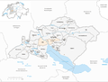
The district of Thun was an administrative unit of the Canton of Bern until December 31, 2009 . The administrative district with the main town Thun comprised 26 communities with 92,248 inhabitants (as of December 31, 2008) on 266.78 km²:
Communities
| Name of the parish | Population (December 31, 2008) |
Area in km² | Inhabitants per km² |
|---|---|---|---|
| Amsoldingen | 801 | 4.71 | 170 |
| Flower stone | 1163 | 15.52 | 75 |
| Buchholterberg | 1524 | 15.33 | 99 |
| Eriz | 510 | 21.78 | 23 |
| Fahrni | 741 | 6.68 | 111 |
| Forst-Längenbühl | 714 | 4.50 | 159 |
| Heiligenschwendi | 631 | 5.55 | 114 |
| Heimberg | 6071 | 5.44 | 1116 |
| Hilterfingen | 3987 | 2.81 | 1419 |
| Hof bei Thun | 410 | 4.60 | 89 |
| Homberg | 505 | 6.51 | 78 |
| Horrenbach beeches | 252 | 20.40 | 12 |
| Oberhofen am Thunersee | 2364 | 2.71 | 872 |
| Oberlangenegg | 488 | 9.16 | 53 |
| Pohlern | 267 | 9.87 | 27 |
| Schwendibach | 253 | 1.49 | 170 |
| Sigriswil | 4608 | 55.41 | 83 |
| Steffisburg | 15,379 | 13.32 | 1155 |
| Teuffenthal (BE) | 171 | 4.53 | 38 |
| Thierachern | 2205 | 7.53 | 293 |
| Tuna | 42,129 | 21.57 | 1953 |
| Uebeschi | 691 | 4.42 | 156 |
| Uetendorf | 5969 | 10.17 | 587 |
| Unterlangenegg | 909 | 6.80 | 134 |
| Wax thorn | 238 | 3.51 | 68 |
| Zwieselberg | 268 | 2.46 | 109 |
| Total (26) | 92,248 | 266.78 | 346 |
Changes in the community
Municipalities until 1912

Municipalities until 1919

Municipalities until 2006

Municipalities until 2009


- 1859: Merger of Blumenstein and Tannenbühl → Blumenstein
- 1869: Heimberg and Thungschneit → Heimberg merge
- 1913: Merger of Goldiwil and Thun → Thun
- 1920: Strättligen and Thun → Thun merged
- 2007: Fusion of Forst and Längenbühl → Forst-Längenbühl
- 2010: District change of all 26 municipalities from the administrative district of Thun → administrative district of Thun
history
In 1218, the Counts of Kyburg received the Thun City Court and the external office with Steffisburg and Sigriswil from Zähringen property. After the Burgdorf War in 1384, the area fell to Bern. With the takeover of the counties on the left and right of the Aare , the entire area became the Thun mayor's office.
During the Helvetic Republic , 1798 to 1803, with the canton of Oberland , the office consisted only of the municipalities of Thun, Oberhofen and Sigriswil, the other municipalities remained with the canton of Bern. This situation lasted until the collapse of the Helvetic Republic , after which the entire area fell back to the Canton of Bern. The administrative district had the above municipal stock from 1863, when the municipalities of Buchholterberg and Wachseldorn were incorporated into the administrative district.
Web links
- Peter Küffer: Thun (Vogtei, administrative district). In: Historical Lexicon of Switzerland .
Individual evidence
Aarberg | Aarwangen | Bern | Biel | Büren | Burgdorf | Courtelary | Erlach | Fraubrunnen | Frutigen | Interlaken | Konolfingen | Laupen | Moutier | La Neuveville | Nidau | Lower Simmental | Oberhasli | Obersimmental | Saanen | Schwarzenburg | Juicy | Signau | Tuna | Trachselwald | Cheeks
Canton of Bern | Districts of Switzerland | Municipalities of the Canton of Bern

Four parishes: Bolligen | Vechigen | Stettlen | Muri
Regional courts: Seftigen | Sternenberg | Konolfingen | Zollikofen
Offices: Thun | Zofingen | Aarau | Lenzburg | Brugg | Burgdorf | Büren | Unterseen | Wiedlisbach | Obersimmental | Lower Simmental | Frutigen | Oberhofen | Aigle | Hasli | Trachselwald | Bipp | Aarwangen | Cheeks | Landshut | Lenzburg (Office) | Schenkenberg | Aarberg | Nidau | Erlach | Laupen | Oltigen | Signau | Biberstein | Aarburg | Saanen | Brandis | Interlaken | Königsfelden | Thorberg | Fraubrunnen | Zofingen (pen) | Frienisberg | St. Johannsen | Gottstatt | Buchsee | Sumiswald | Roche (Saline) | Köniz | Kasteln | Hettiswil
Offices in Vaud: Avenches | Moudon | Yverdon | Lausanne | Morges | Nyon | Vevey | Romainmôtier | Oron | Payerne | Bonmont | Aubonne
Common lords with Freiburg: Schwarzenburg | Murten | Grandson | Echallens
Common federal dominions: Baden | Thurgau | Free offices | Rhine Valley | Sargans | Locarno | Lugano | Mendrisio | Valle Maggia
Offices and services in the city of Bern: Bauamt | Salt Directorate | Mushafen | Pen | Corn Office | Big hospital | Inselspital