Trachselwald district
| Trachselwald district | |
|---|---|
| Basic data | |
| Country: |
|
| Canton : |
|
| Main town : | Trachselwald |
| Area : | 191.04 km² |
| Residents: | 23,279 (December 31, 2008) |
| Population density : | 122 inhabitants per km² |
| map | |
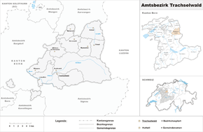
The Trachselwald district was an administrative unit of the Canton of Bern until December 31, 2009 . The seat of the governor was Trachselwald Castle in Trachselwald . The district comprised ten municipalities with 23,279 inhabitants (as of December 31, 2008) on 191.04 km²:
Communities
| Name of the parish | Population (December 31, 2008) |
Area in km² | Inhabitants per km² |
|---|---|---|---|
| Affoltern in the Emmental | 1161 | 11.51 | 101 |
| Dürrenroth | 1049 | 14.13 | 74 |
| Eriswil | 1373 | 11.34 | 121 |
| Huttwil | 4690 | 17.24 | 272 |
| Lützelflüh | 4123 | 26.87 | 153 |
| Rüegsau | 3031 | 15.06 | 201 |
| Sumiswald | 5084 | 59.34 | 86 |
| Trachselwald | 1038 | 15.96 | 65 |
| Walterswil | 558 | 7.90 | 71 |
| Wyssachen | 1172 | 11.69 | 100 |
| Total (10) | 23,279 | 191.04 | 122 |
Changes in the community
- 1908: Change of name Wyssachengraben → Wyssachen
- 2010: District change Eriswil , Huttwil , Walterswil and Wyssachen from the Trachselwald district → Oberaargau district
- 2010: District change Affoltern im Emmental , Dürrenroth , Lützelflüh , Rüegsau , Sumiswald and Trachselwald from the Trachselwald district → Emmental district
swell
- Anne-Marie Dubler : The legal sources of the Canton of Bern, Part Two: Rights of the Landscape, Volume 8: The Law of the Emmental Landscape (Signau and Trachselwald districts since 1803) (= Swiss Lawyers Association. Legal Sources Foundation [ed.]: Collection of Swiss legal sources . II . Department). Sauerländer, Aarau 1991, ISBN 3-7941-3107-X ( online ).
Web links
Commons : District Trachselwald - Collection of images, videos and audio files
- Anne-Marie Dubler : Trachselwald (rule, administrative district). In: Historical Lexicon of Switzerland .


