
Trachselwald
| Trachselwald | |
|---|---|
 |
|
| State : |
|
| Canton : |
|
| Administrative district : | Emmental |
| BFS no. : | 0958 |
| Postal code : | 3456 |
| Coordinates : | 622 914 / 207334 |
| Height : | 685 m above sea level M. |
| Height range : | 657–1194 m above sea level M. |
| Area : | 15.96 km² |
| Residents: | 960 (December 31, 2018) |
| Population density : | 66 inhabitants per km² |
| Website: | www.trachselwald.ch |
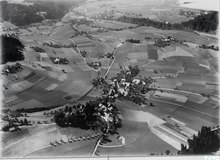
_072.JPG) Trachselwald, view from the castle tower |
|
| Location of the municipality | |
  |
|
Trachselwald ( Bernese German Trachsuwaud [trɑχsʊˌʋɑɯd] or short Trachsu [trɑχsʊ] ) is a municipality in the administrative district of Emmental of the Swiss canton of Bern .
geography
The municipality is located east of the Emme and south of the Grünen in the lower Emmental and mainly comprises the Heimisbach valley with the towns of Chramershus and Thal . The village of Trachselwald itself lies close to the western municipal boundary. The neighboring communities in the north, starting clockwise, are Lützelflüh , Sumiswald , Trub , Langnau im Emmental , Lauperswil and Rüderswil .
history
The name of the community is a combination of the job title "Drechsler" (Old High German trāhsil ) and the generic word forest and thus means "Drechsler-Wald". The place is first mentioned in a document around 1131 as Trahselwalt .
The village around Trachselwald Castle was initially subordinated to the Barons of Trachselwald, then to those of Rüti near Lyssach and finally to those of Sumiswald until the rule was sold to the city of Bern in 1408 . The castle was then used as the seat of the bailiwick .
In 1574 the village was destroyed by fire. In the course of the Swiss Peasants' War , a meeting took place on April 3, 1653 in the “Tanne” inn, at which the peasant leader Niklaus Leuenberger made his first public appearance. On June 19, he was arrested and until his execution on August 27 in the keep imprisoned the castle.
The Heimisbach valley belonging to the municipality of Trachselwald was called "Dürrgraben" until 1967. On January 1, 1968, on the 100th birthday of the dialect writer Simon Gfeller , it was given its current name after the title of his first work from 1910.
population
| Population development | ||||||||||||
|---|---|---|---|---|---|---|---|---|---|---|---|---|
| year | 1900 | 1950 | 1970 | 1980 | 1990 | 2002 | 2009 | 2012 | 2015 | |||
| Residents | 1473 | 1393 | 1199 | 1054 | 1046 | 1078 | 1047 | 995 | 977 | |||
politics
The voting shares of the parties in the 2019 National Council election were: SVP 53.0%, BDP 12.7%, SP 5.8%, GPS 8.4%, EDU 5.6%, EPP 3.2%, FDP 3.4 %, glp 3.3%, 5G goodbye! 1.0%, CVP 0.3%.
Arts and Culture
The Baroque reconstruction of the Reformed Church Trachselwald took place in 1685, designed by Abraham Dünz .
The oldest parts of the castle date from the 2nd half of the 12th century; until the end of 2009 this was the seat of the governor of the Trachselwald office (since January 1, 2010 the municipality of Trachselwald has been part of the Emmental administrative district).
Since March 2003, is staying in the premises of the 1614-built former Office schaffnerei the Swiss Zither -Culture center, which has existed since February 1999, initially in Konolfingen was located.
In the old schoolhouse in Thal in Heimisbach, where Simon Gfeller went to school from 1875 to 1884, there has been a memorial room for him since 1970.
Personalities
- Johann Rudolf Gruner (1680–1761), pastor in Trachselwald from 1707 to 1725
- Gottlieb Sigmund Gruner (1717–1778), born in Trachselwald, natural scientist
- Fritz Berger (1868–1950), born in Trachselwald, founder of the Church for Christ
- Simon Gfeller (1868–1943), born in Trachselwald, teacher and dialect writer
photos
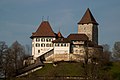
Trachselwald Castle

Church and castle

Rectory

Spycher


literature
- Anne-Marie Dubler : Trachselwald (community). In: Historical Lexicon of Switzerland .
- Hans Minder: The citizens of the community Trachselwald. Lauperswil 2009.
- Hans Minder: Heimatbuch von Trachselwald - Historical Lexicon. Trachselwald 2018.
- Jürg Schweizer: Trachselwald. Village, castle, community (= Swiss Art Guide. No. 154). Edited by the Society for Swiss Art History GSK, Bern 1992, ISBN 978-3-85782-154-7 .
swell
- Collection of Swiss Legal Sources, Section II: The Legal Sources of the Canton of Bern, Part Two: Rights of the Landscape, Volume 8: The Laws of the Emmental Landscape (Signau and Trachselwald districts since 1803). Arranged by Anne-Marie Dubler. Aarau 1991 ( online version ).
Web links
Individual evidence
- ↑ Permanent resident population from STAT-TAB of the BfS , municipalities see also regional portraits 2020 on bfs.admin.ch, accessed on May 29, 2020
- ↑ a b Lexicon of Swiss municipality names . Edited by the Center de Dialectologie at the University of Neuchâtel under the direction of Andres Kristol. Frauenfeld / Lausanne 2005, p. 879.
- ↑ Results of the Trachselwald community. State Chancellery of the Canton of Bern, October 20, 2019, accessed on August 3, 2020 .
Aefligen | Affoltern im Emmental | Alchenstorf | Bätterkinden | Burgdorf | Dürrenroth | Eggiwil | Ersigen | Hasle near Burgdorf | Heimiswil | Hellsau | Hindelbank | Höchstetten | Kernenried | Kirchberg | Koppigen | Krauchthal | Langnau im Emmental | Lauperswil | Lützelflüh | Lyssach | Mötschwil | Oberburg | Röthenbach im Emmental | Rüderswil | Rüdtligen-Alchenflüh | Rüegsau | Rumendingen | Rüti near Lyssach | Schangnau | Signau | Sumiswald | Trachselwald | Trub | Trubschachen | Utzenstorf | Wiler near Utzenstorf | Willadingen | Wynigen | Zielebach
Former parishes: Bärau | Bickigen-Schwanden | Crusher houses | Niederösch | Oberösch | Wil at Koppigen
Canton of Bern | Administrative districts of the canton of Bern | Municipalities of the Canton of Bern