Oberösch
| Oberösch | ||
|---|---|---|
| State : |
|
|
| Canton : |
|
|
| Administrative district : | Emmental | |
| Residential municipality : | Ersigen | |
| Postal code : | 3424 | |
| former BFS no. : | 0419 | |
| Coordinates : | 613 008 / 217 496 | |
| Height : | 489 m above sea level M. | |
| Area : | 2.1 km² | |
| Residents: | 104 (December 31, 2015) | |
| Population density : | 50 inhabitants per km² | |
| Website: | www.ersigen.ch | |
|
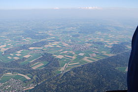
Oberösch (top right from the center of the picture) |
||
| map | ||
|
|
||
Until December 31, 2015, Oberösch was a political municipality in the Emmental administrative district of the canton of Bern in Switzerland . On January 1, 2016, it merged with Ersigen and Niederösch to form the municipality of Ersigen.
geography
Oberösch lies at 489 m above sea level. M. , six kilometers north of the city of Burgdorf (linear distance ). The scattered settlement extends on the Ösch , on the eastern edge of the wide alluvial plain of the Emme , in the Swiss plateau .
The area of the 2.1 km² former municipal area covers a section of the central Bernese plateau. The western half of the area lies in the flat Emme plain (on average 490 m above sea level ) and extends over the agriculturally intensively used Grossacher to the west to the Hubel . The valley of the canalized Ösch occupies the central part. The eastern part of the municipality, on the other hand, is located in the Molasse hill country , which was shaped by the Ice Age Rhone glacier . The former municipality extends over a relatively gently rising slope on the ridge of the Reiteggwald , on which at 590 m above sea level. M. the highest point of Oberösch is reached, and into the Rychenbrunnentälchen in the catchment area of the Chänerechbach . In 1997, 4% of the former municipal area was accounted for by settlements, 35% for forests and woodlands and 61% for agriculture.
Oberösch consists of different farm groups. Neighboring communities of Oberösch were Niederösch , Rumendingen , Ersigen and Utzenstorf .
population
With 104 inhabitants (as of December 31, 2015) Oberösch was one of the smallest communities in the canton of Bern. Of the residents, 97.4% speak German, 1.8% Polish and 0.9% speak English (as of 2000). The population of Oberösch was 162 inhabitants in 1850, 158 inhabitants in 1900. In the course of the 20th century, the population decreased by 35% to 105 people by 1990 due to strong emigration. Since then, a slight increase in population has been recorded.
economy
Thanks to the fertile soils, Oberösch still lives from agriculture , in particular from arable farming , fruit growing and cattle breeding . Outside the primary sector there are only very few jobs in the village. Many workers are commuters who work mainly in the larger towns in the area, in the Burgdorf region and in the Solothurn area .
traffic
The community is very well developed in terms of traffic. It is only about one kilometer off the main road 1 from Bern to Zurich . The next connection to the A1 motorway (Bern-Zurich) is around six kilometers from the town center. Oberösch is connected to the public transport network by a bus line from Regionalverkehr Mittelland , which operates the Koppigen to Burgdorf route.
history
The place was first mentioned in a document in 886 under the name Osse ; from 1309 the name Oescho has been handed down. These two names cannot be clearly assigned to Oberösch or Niederösch. For the first time, a distinction is made between the two localities in 1310 ( Oeschge superioris ); Obern Oesch then appears in 1338 .
In the High Middle Ages , Oberösch first belonged to the Kingdom of Hochburgund and the royal court of Kirchberg. Later, the village was under the sovereignty of the Zähringer and from the 13th century under that of the Kyburger . It was temporarily owned by the Thorberg monastery. Since 1423 Twing and Bann lay with the city of Burgdorf. Under the rule of Bern, Oberösch was assigned to the Landvogtei Wangen. After the collapse of the Ancien Régime (1798), the village belonged to the Burgdorf district during the Helvetic period and from 1803 to the Burgdorf Oberamt, which received the status of an official district with the new cantonal constitution of 1831.
On January 1, 2016 Oberösch was incorporated into Ersigen together with Niederösch .
Attractions
The Oberösch farm groups have preserved numerous characteristic farmhouses in the typical Bernese country style from the 17th to 19th centuries.
Web links
Individual evidence


