
Koppigen
| Koppigen | |
|---|---|
 |
|
| State : |
|
| Canton : |
|
| Administrative district : | Emmental |
| BFS no. : | 0413 |
| Postal code : | 3425 |
| Coordinates : | 612 560 / 220429 |
| Height : | 475 m above sea level M. |
| Height range : | 459-523 m above sea level M. |
| Area : | 6.93 km² |
| Residents: | 2095 (December 31, 2018) |
| Population density : | 302 inhabitants per km² |
| Website: | www.koppigen.ch |
_142.JPG) Koppigen, photographed from a balloon on April 16, 2011 |
|
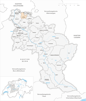
| Location of the municipality | |
  |
|
Koppigen is a municipality in the Emmental administrative district in the canton of Bern in Switzerland .
geography

Koppigen is located in the northeast of the canton of Bern on the border with the canton of Solothurn . The village borders on the Bernese communities of Willadingen , Höchstetten , Alchenstorf , Ersigen , Utzenstorf and Zielebach as well as the Solothurn communities of Obergerlafingen and Recherswil in the Wasseramt district . The village lies on the foothills of the hilly landscape east of the Emme and is traversed by the Oesch brook.
Climate table
| Koppigen, 1981-2010 | ||||||||||||||||||||||||||||||||||||||||||||||||
|---|---|---|---|---|---|---|---|---|---|---|---|---|---|---|---|---|---|---|---|---|---|---|---|---|---|---|---|---|---|---|---|---|---|---|---|---|---|---|---|---|---|---|---|---|---|---|---|---|
| Climate diagram | ||||||||||||||||||||||||||||||||||||||||||||||||
| ||||||||||||||||||||||||||||||||||||||||||||||||
|
Average monthly temperatures and rainfall for Koppigen, 1981–2010
Source:
|
||||||||||||||||||||||||||||||||||||||||||||||||||||||||||||||||||||||||||||||||||||||||||||||||||||||||||||||||||||||||||||||||||||||||||||||||||||||
The heat record in Koppigen was set on June 27, 2019 at 36.5 ° C.
population
With 2095 inhabitants (as of December 31, 2018), Koppigen is one of the medium-sized communities in the canton of Bern. 94.5% of the residents speak German, 1.2% speak Albanian and 0.8% speak Serbo-Croatian (as of 2000). The population of Koppigen was 1012 in 1850 and 1102 in 1900. The population increased steadily over the course of the 20th century. In 1950, 1551 inhabitants were counted, at the turn of the millennium Koppigen cracked the 2000 population limit.
politics
The voting shares of the parties in the 2019 National Council election were: SVP 37.7%, BDP 13.4%, SP 13.2%, FDP 8.0%, glp 10.1%, GPS 9.0%, EVP 2.1 %, EDU 1.4%, CVP 1.1%, pirates 0.7%.
traffic
Koppigen has no rail connection. There are bus connections to Burgdorf and Wynigen (operated by BLS AG ) and to Utzenstorf - Bätterkinden (operated by RBS ).
Educational institutions
The Bernese cantonal horticultural school and other related organizations are located on the Oeschberg . Every two years at the end of June, the Swiss trade fair for gardening, fruit and vegetable growing, öga , the most important trade fair for the green sector in Switzerland, takes place on the school grounds .
Attractions
Personalities
- Samuel Gottlieb Hünerwadel (1771–1848), Protestant clergyman and university professor in Bern
- Walter Schädelin (1873–1953), forest scientist
- Otto Tschumi (1878–1960), prehistoric
- Albert Schädelin (1879–1961), Protestant clergyman and university professor in Bern
literature
- Jeremias Gotthelf , Kurt von Koppigen , short story, 1850
Web links
- Official website of the municipality of Koppigen
- Anne-Marie Dubler : Koppigen. In: Historical Lexicon of Switzerland .
Individual evidence
- ↑ Permanent resident population from STAT-TAB of the BfS , municipalities see also regional portraits 2020 on bfs.admin.ch, accessed on May 29, 2020
- ↑ Climate table. In: meteoschweiz.admin.ch. meteoschweiz, accessed on May 24, 2018 .
- ↑ Maximum temperatures - New heat records in both the north and the south. In: srf.ch . June 27, 2019, accessed June 27, 2019 .
- ↑ Results of the municipality of Koppigen. State Chancellery of the Canton of Bern, October 20, 2019, accessed on July 30, 2020 .
- ^ Website of the horticultural school. ( Memento of the original from February 29, 2012 in the Internet Archive ) Info: The archive link was inserted automatically and has not yet been checked. Please check the original and archive link according to the instructions and then remove this notice.
Aefligen | Affoltern im Emmental | Alchenstorf | Bätterkinden | Burgdorf | Dürrenroth | Eggiwil | Ersigen | Hasle near Burgdorf | Heimiswil | Hellsau | Hindelbank | Höchstetten | Kernenried | Kirchberg | Koppigen | Krauchthal | Langnau im Emmental | Lauperswil | Lützelflüh | Lyssach | Mötschwil | Oberburg | Röthenbach im Emmental | Rüderswil | Rüdtligen-Alchenflüh | Rüegsau | Rumendingen | Rüti near Lyssach | Schangnau | Signau | Sumiswald | Trachselwald | Trub | Trubschachen | Utzenstorf | Wiler near Utzenstorf | Willadingen | Wynigen | Zielebach
Former parishes: Bärau | Bickigen-Schwanden | Crusher houses | Niederösch | Oberösch | Wil at Koppigen
Canton of Bern | Administrative districts of the canton of Bern | Municipalities of the Canton of Bern