
Obergerlafingen
| Obergerlafingen | |
|---|---|
 |
|
| State : |
|
| Canton : |
|
| District : | Water authority |
| BFS no. : | 2528 |
| Postal code : | 4564 |
| Coordinates : | 610 974 / 223 360 |
| Height : | 462 m above sea level M. |
| Height range : | 452–467 m above sea level M. |
| Area : | 1.51 km² |
| Residents: | 1176 (December 31, 2018) |
| Population density : | 779 inhabitants per km² |
| Website: | www.obergerlafingen.ch |
_393.JPG) Obergerlafingen |
|
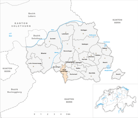
| Location of the municipality | |
  |
|
Obergerlafingen ( Obrgerlafinge in the local dialect ) is a municipality in the Wasseramt district of the canton of Solothurn in Switzerland .
geography

Obergerlafingen lies at 462 m above sea level. M. , 6 km southeast of the canton capital Solothurn (air line). The village extends on the alluvial plain between the Emme in the west and the Ösch in the east, on the Sagibach, in the southern Solothurn Mittelland .
The area of the 1.5 km² municipal area includes a section of the groundwater-rich gravel plain in the central water authority. The municipality ground lies on both sides of the Sagibach and extends in a narrow strip to the south into the Obergerlafingen forest (at 466 m above sea level, the highest elevation in Obergerlafingen) and to the north over the Gerkmatten meadow to the edge of the oak wood . In 1997, 30% of the municipal area was in settlements, 19% in forests and woodlands, 50% in agriculture and a little less than 1% was unproductive land.
Neighboring communities of Obergerlafingen are Gerlafingen , Kriegstetten and Recherswil in the canton of Solothurn and Koppigen and Zielebach in the canton of Bern .
population
With 1176 inhabitants (as of December 31, 2018) Obergerlafingen is one of the medium-sized communities in the canton of Solothurn. 97.1% of the residents speak German, 1.2% speak Italian and 0.8% speak French (as of 2000). The population of Obergerlafingen was 136 in 1850 and 378 in 1900. In the course of the 20th century the population increased continuously (1970 888 inhabitants). Today the settlement area of Obergerlafingen has grown together almost completely with that of Zielebach.
politics
On June 28, 2009 the municipal council was elected for the 2009-2013 term. Although the Swiss People's Party was unable to win a seat, it was represented in the council at the end of its term of office by a change of council member Marcel Zuber from the non-party to the SVP. In the following municipal election on April 14, 2013, Zuber was officially elected as an SVP member in the municipal council.
| Political party | 2013-2017 | (+/-) | 2009-2013 |
|
FDP. The Liberals ( Free Democratic Party until 2009 ) |
(3) |
3 | |
| Social Democratic Party | 2 | 2 | |
| Non-party | (1) |
2 | |
| Swiss People's Party | 1 | +1 | 0 / (1) |
economy
Up until the middle of the 20th century, Obergerlafingen was a village dominated by agriculture . Today arable and fruit growing as well as cattle breeding have only a marginal role in the employment structure of the population. Numerous other jobs are available in local small businesses and in the service sector. Since the 1960s, thanks to the good traffic situation, various small and medium-sized companies have settled in Obergerlafingen. Today there are companies in the building trade, the electrical industry, window construction, a carpenter's shop and a printing shop in the town. In the last few decades the village has also developed into a residential community. Many employed people are therefore commuters who work mainly in the Solothurn and Bern regions.
traffic
The community has good transport links. It is located on a connecting road from Biberist to Koppigen . The next connection to the A1 motorway (Bern-Zurich), which in sections forms the eastern municipal border, is around 2 km from the town center. By bus the BSU which the diameter line the Solothurn region, the distance of Obergerlafingen via Solothurn to Bellach operated, the village is connected to the public transport network.
history
The place was first mentioned in a document in 1278 under the name Obergeroluingen . The names Oberngerolfingen (1363) and Obergerlafingen (1449) appeared later . The place name is derived from the Germanic personal name Gerolf .
In the Middle Ages , Obergerlafingen was probably part of the Koppigen rule. Later it formed its own small lordship together with Niedergerlafingen, today's Gerlafingen. In 1466 the village was acquired by the city of Solothurn and assigned to the Warstetten Bailiwick. It was not until the Wyniger Treaty in 1665 that the high level of jurisdiction was transferred from Bern to Solothurn. After the collapse of the Ancien Régime (1798), Obergerlafingen belonged to the Biberist district during the Helvetic Republic and from 1803 to the Kriegstetten district, which was officially renamed the Wasseramt district in 1988. With the establishment of Von Rollschen Eisenwerke in Gerlafingen (1811) and the paper factory in Biberist (1862), Obergerlafingen also experienced a significant increase in population due to strong immigration. Obergerlafingen does not have its own church; it belongs to the parish of Kriegstetten.
coat of arms
- Three white six-pointed stars arranged in stakes in red
Web links
- Official website of the municipality of Obergerlafingen
- Stefan Frech: Obergerlafingen. In: Historical Lexicon of Switzerland .
Individual evidence
- ↑ Permanent and non-permanent resident population by year, canton, district, municipality, population type and gender (permanent resident population). In: bfs. admin.ch . Federal Statistical Office (FSO), August 31, 2019, accessed on December 22, 2019 .
- ↑ Solothurner Zeitung: Despite a previous seat - SVP is competing in Obergerlafingen for the first time
- ↑ Minutes of the local council of the community of Obergerlafingen (edition 48; from April 24, 2013; PDF; 79 kB)
- ^ Solothurner Zeitung : This is how the new municipal councils are composed
Aeschi |
Beaverist |
Bolken |
Deitingen |
Derendingen |
Three courtyards |
Etziken |
Gerlafingen |
Hold |
Horriwil |
Hüniken |
Kriegstetten |
Lohn-Ammannsegg |
Luterbach |
Obergerlafingen |
Oekingen |
Recherswil |
Subingen |
Zuchwil
Former communities: Ammannsegg | Burgäschi | Heinrichswil | Heinrichswil-Winistorf | Hersiwil | Wages | Steinhof | Winistorf
Canton of Solothurn | Districts of the Canton of Solothurn | Municipalities of the Canton of Solothurn