
Beaverist
| Beaverist | |
|---|---|
 |
|
| State : |
|
| Canton : |
|
| District : | Water authority |
| BFS no. : | 2513 |
| Postal code : | 4562 |
| UN / LOCODE : | CH BIB |
| Coordinates : | 609 095 / 225 796 |
| Height : | 447 m above sea level M. |
| Height range : | 426-544 m above sea level M. |
| Area : | 12.25 km² |
| Residents: | 8568 (December 31, 2018) |
| Population density : | 699 inhabitants per km² |
| Website: | www.biberist.ch |
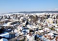
 Beaverist in winter |
|
| Location of the municipality | |
  |
|
Biberist ( Biberischt in the local dialect ) is a municipality in the Wasseramt district of the canton of Solothurn in Switzerland .
geography
Biberist is 447 m above sea level. M. , 3 km south-southeast of the canton capital Solothurn (air line). The industrial community extends on the lower Emme and on the Dorfbach , the lower reaches of the Biberenbach , on the northeastern edge of the Molasse heights of the Bucheggberg and on the edge of the alluvial plain of the Emme, in the Solothurn Mittelland .
With an area of 12.4 km², Biberist is the largest municipality in the Wasseramt district. It comprises a section of the groundwater-rich gravel plain in the inner water authority and the molasse hill country bordering to the west . The central part is the plain through which the Emme and the Dorfbach (Biberbach) flow. To the east of the canalised Emme, the area extends over the Eichmatt to the Grüttbach . To the west of the river is the 1 km wide valley level of the lowest part of the Biberenbach. The Altisberg ( 496 m above sea level ), a wooded foothill of the Bucheggberg, extends to the southern edge of Biberist and separates the plains of the Emme and Biberental.
To the north of the village, the municipality encompasses the approximately 500 m wide valley basin used by the main modes of transport between Solothurn and Biberist between the Bleichenberg ( 498 m above sea level ) in the east and the Oberwald (up to 541 m above sea level ) in the west. The houses on the northern slope of the Gisihübeli ( 484 m above sea level ), which have grown together structurally with the city of Solothurn, are also part of Biberist.
In a narrow strip, the municipality extends northwest to the Aare above Solothurn and includes the northeastern part of the Bucheggberg with Oberwald , the Wildmannwald , the Wildmanngraben in between , the Hunnenberg ( 491 m above sea level ) and reaches in the area to the west the clearing island Buechhof (part of Lohn-Ammannsegg) with 543 m above sea level. M. the highest elevation of Biberist. The western border runs along the Bärenbach , a short right tributary of the Aare. In 1997, 25% of the municipal area was in settlements, 35% in forests and woodlands, 38% in agriculture and a little less than 2% was unproductive land.
Biberist consists of the former settlement centers Unterbiberist ( 444 m above sea level ) on the Emme south of the Bleichenberg, Oberbiberist ( 455 m above sea level ) on the Dorfbach, extensive industrial and residential quarters and a few individual farms. Neighboring communities of Biberist are Lohn-Ammannsegg , Lüsslingen-Nennigkofen , Bellach , Solothurn , Zuchwil , Derendingen and Gerlafingen in the canton of Solothurn and Bätterkinden in the canton of Bern .
population
With 8,568 inhabitants (as of December 31, 2018), Biberist is one of the larger communities in the canton of Solothurn. 87.4% of the residents speak German, 3.6% speak Italian and 2.3% speak Serbo-Croatian (as of 2000). The population of Biberist increased steadily over the course of the 20th century, with particularly strong growth rates being observed during the 1950s. After a peak of around 7,800 inhabitants in the early 1970s, a slight population decline was recorded. The population has remained relatively constant since around 1980 and has shown a slight upward trend again in recent years. The settlement area of Biberist has merged seamlessly with that of Gerlafingen; the northernmost quarters also adjoin the residential areas of Solothurn and Zuchwil.
| 1850 | 1900 | 1920 | 1940 | 1950 | 1960 | 1970 | 1980 | 1990 | 2000 | 2010 |
|---|---|---|---|---|---|---|---|---|---|---|
| 1071 | 2871 | 3541 | 4774 | 5283 | 7188 | 7769 | 7519 | 7413 | 7603 | 8008 |
politics
The municipal council (executive), including the municipality president, consists of 11 members. The seats are distributed as follows:
| Political party | 2014-2017 | (+/-) | 2009-2013 |
| Social Democratic Party | 4th | 4th | |
|
FDP. The Liberals ( Free Democratic Party until 2009 ) |
3 | 3 | |
| Swiss People's Party | 2 | 2 | |
| Christian Democratic People's Party | 2 | 2 |
economy
Until the second half of the 19th century, Biberist was a predominantly agricultural village. The water power of the Biberenbach has been used to operate a mill since the 15th century. On a side canal of the Emme there was an oil mill from 1747, a saw from 1757 and a powder mill from 1776. The latter was destroyed by an explosion in 1805, but then rebuilt until operations ceased in 1845. On the outskirts of Solothurn, but in the area of Biberist, there had been a beer brewery and a tobacco factory since the early 19th century. After 1860, the town experienced a rapid economic upswing through the establishment of the Biberist paper mill.
Today Biberist offers around 3000 jobs. With 3% of the workforce who are still employed in the primary sector, agriculture (predominantly arable farming and forestry ) only has a minor role in the employment structure of the population. Around 52% of the workforce is employed in the industrial sector, while the service sector accounts for 45% of the workforce (as of 2001).
The larger industrial and commercial areas of Biberist are to the east of the Emme. The most important employer in the municipality until 2011 was the paper mill with around 550 jobs. The factory previously belonged to Biber Holding AG, went bankrupt in 1997 to the Finnish paper company M-real , and was taken over on September 29, 2008 by the South African company Sappi . In July 2011, Sappi announced the closure of the paper mill - 149 years after it was founded. In summer 2012 the area was acquired by the company HIAG Immobilien. Since the first half of the 20th century, the industry has diversified, so that today many different branches are represented in Biberist. These include companies in the metal construction, electronic industry, construction industry, automobile trade, wood processing, horticulture and various mechanical workshops.
Jobs in the tertiary sector are mainly found in administration, education, sales, catering, banking and insurance. Biberist was also the location of the cantonal penal institution Oberschöngrün (founded in 1924, closed in 2014). The village has also developed into a residential community. In addition to numerous commuters, many employees are commuters who work mainly in Solothurn, but also in the Bern region.

Biberist paper mill

Biberist paper mill

Biberist paper mill, lithograph, 1883

Coop Biberist
School buildings / municipal administration
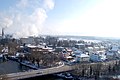
Emmebrücke / Grüttquartier


traffic
The community has excellent transport links. It is located on the main road from Solothurn to Bern . The nearest connection to the A1 motorway (Bern-Zurich) is around 4 km from the town center. The A5 (Solothurn-Biel) opened in 2002 with the half-way connection Solothurn-Süd is 2 km away from Biberist. Tempo 30 zones were introduced almost across the board as of September 2019.
On May 26, 1875, the railway line from Solothurn to Burgdorf was put into operation with a train station in Biberist. The route from Solothurn to Zollikofen , which is operated today by Regionalverkehr Bern – Solothurn , with two stops in the community, was opened on April 10, 1916. Today the train continues to Bern and has only one stop in Biberist. The BSU bus routes , which serve the routes from Bellach to Lohn-Ammannsegg , from Bellach to Kriegstetten and from Solothurn to Biberist, ensure the fine distribution of public transport .
history


The municipal area of Biberist was inhabited very early. The earliest evidence of human presence comes from the Neolithic , when a settlement was built on the Altisberg. Other finds come from the Bronze Age . On the outskirts of Solothurn, during archaeological excavations in connection with the construction of the A5 autobahn, the remains of a Roman estate , presumably inhabited from the 1st to the 3rd century AD, were discovered; numerous small finds were also made. The area near the road from Aventicum (Avenches) to Salodurum (Solothurn) was used as a burial ground in the early Middle Ages .
The place was first mentioned in a document in 763 under the name Biberussa ; The spelling Biberusse is still handed down in the 8th century . Later, the names Pibirsin (10th century), Bibirussa , Biberhusen , Bubrusche (1251), Bibersche (1268), Bierösch , Biberesche and Bibersech appeared . The current name was first handed down from 1508. The place name is of Celtic origin, as indicated by the ending -ussa in the first mention. It means little water , brook .
In the Middle Ages , Biberist belonged to the Landgraviate of Burgundy . A noble family from Bibirusa has been mentioned since the early 11th century, possibly having their seat on the Burghubel (Altisberg). After the family died out in the 14th century, property came to wealthy families in the city of Solothurn. The Bleichenberg, still a small village in the 14th century, belonged to the Spiegelberg family. The St. Ursenstift in Solothurn held the lower jurisdiction over Biberist, which was exercised by the Counts of Buchegg . In 1370 the lower court came directly to the city of Solothurn. When the rule of Halt came to Solothurn in 1466, Biberist was assigned to the new Vogtei Kriegstetten and made a place of jurisdiction. The high level of jurisdiction over the village also came to Solothurn in 1516.
After the collapse of the Ancien Régime (1798), Biberist formed a district during the Helvetic period (comprised the area of the former bailiffs Bucheggberg and Kriegstetten) in the Solothurn administrative district. From 1803 the village belonged to the Kriegstetten district, which was officially renamed the Wasseramt district in 1988. The Biberist, which formerly consisted of two separate villages, Unterbiberist (also called Niederbiberist) and Oberbiberist, was united in a political municipality in 1857.
The industrialization took about 1860 feet in the village, the Emme was built as a side channel to the east, the paper mill Biberist was founded in the 1862nd It helped the place to an economic upswing and a significant increase in population. Numerous craft workshops and suppliers for the watch industry were added later. In the course of the 20th century, Biberist developed more and more into an industrial and residential suburb of Solothurn.
Since the groundwater of Biberist to high levels of pesticide chlorothalonil were detected, has since 2019 drinking water from Recherswil be purchased.
Attractions

- The Catholic Church of St. Mary, already mentioned in 763 and probably relocated to its present location in 1470 after a flood in the Emme, was given its present-day appearance when it was rebuilt in 1845 in the classicism style . Remodeling took place during the 20th century.
- The Reformed Church was consecrated in 1910.
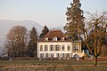
- There are several mansions in the municipality, including the front Bleichenberg castle, which was built between 1602 and 1609, was changed to the Türmlihaus around 1680 and today serves as Biberist's cultural center (painting and art collection of the Moos-Flury Foundation) Schoengrün Castle, built in the French style in the 18th century.

Stapfacker district Biberist
Nursing home Elisabethheim the Ingenbohl sisters , behind-Bleichenberg

Reformed Church, new renovation + extension 7/2008

Primary school building with old gym


Culture
In Biberist there is a community library in the Bleichematt school house for general use. On August 17, 2019, the "Blick Esports Masters" Cup (an Esport Counter-Strike Global Offensive tournament) with a total prize money of $ 10,000 took place here.
coat of arms
- Divided by red and white, covered with two crossed hooks in alternating colors.
- The collar hooks indicate the earlier rafting trade in the place
Personalities
- Oscar Miller (1826–1893), founder of the Biberist paper mill
- Simon Kaiser (1828–1898), politician, legal scholar and bank manager
- Ludwig Rochus Schmidlin (1845–1917), pastor in Biberist and church historian
- Oscar Miller (1862–1934), paper manufacturer
- Moritz Tramer (1882–1963), psychiatrist
- Werner Miller (1892–1959), painter
- Richard Flury (1896–1967), conductor and composer
- Olga Kaiser (1897–1947), writer and playwright
- Hans Rudolf Stampfli (1925–1994), archaeozoologist
- Urs Altermatt (* 1942), historian
- Reto U. Schneider (* 1963), science journalist
- Alex Miescher (* 1968), former sports official, competitive athlete and former local councilor (FDP)
Web links
- Official website of the municipality of Biberist
- Peter Kaiser: Beaverist. In: Historical Lexicon of Switzerland .
Individual evidence
- ↑ Permanent and non-permanent resident population by year, canton, district, municipality, population type and gender (permanent resident population). In: bfs. admin.ch . Federal Statistical Office (FSO), August 31, 2019, accessed on December 22, 2019 .
- ↑ a b Biberist website: The municipal councils for the 2013-2017 term of office
- ↑ Biberist: The municipal councils for the 2009-2013 term of office ( Memento from November 22, 2012 in the Internet Archive )
- ↑ Biberist paper mill closes definitely , Regionaljournal Aargau Solothurn, DRS 1 , July 21, 2011.
- ↑ http://www.papieri-biberist.ch/ Accessed January 18, 2015
- ^ Website of the Cantonal Office of Justice ( Memento from December 8, 2014 in the Internet Archive )
- ↑ Rahel Meier: The discussion about Tempo 30 has started again. In: solothurnerzeitung.ch . August 30, 2019, accessed September 11, 2019 .
- ↑ Gundi Klemm: 2150 cubic meters of water every day: Recherswil delivers clean drinking water to Biberist. In: solothurnerzeitung.ch . December 20, 2019, accessed December 22, 2019 .
- ↑ Christine Zürcher: The Reformed Church Biberist-Gerlafingen. (Swiss Art Guide, No. 862, Series 87). Ed. Society for Swiss Art History GSK. Bern 2009, ISBN 978-3-85782-862-1 .
Aeschi |
Beaverist |
Bolken |
Deitingen |
Derendingen |
Three courtyards |
Etziken |
Gerlafingen |
Hold |
Horriwil |
Hüniken |
Kriegstetten |
Lohn-Ammannsegg |
Luterbach |
Obergerlafingen |
Oekingen |
Recherswil |
Subingen |
Zuchwil
Former communities: Ammannsegg | Burgäschi | Heinrichswil | Heinrichswil-Winistorf | Hersiwil | Wages | Steinhof | Winistorf
Canton of Solothurn | Districts of the Canton of Solothurn | Municipalities of the Canton of Solothurn