
Subingen
| Subingen | |
|---|---|
 |
|
| State : |
|
| Canton : |
|
| District : | Water authority |
| BFS no. : | 2532 |
| Postal code : | 4553 |
| UN / LOCODE : | CH SBI |
| Coordinates : | 613387 / 227348 |
| Height : | 440 m above sea level M. |
| Height range : | 433–477 m above sea level M. |
| Area : | 6.27 km² |
| Residents: | 3203 (December 31, 2018) |
| Population density : | 511 inhabitants per km² |
| Website: | www.subingen.ch |
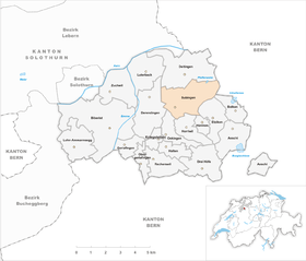
| Location of the municipality | |
  |
|
Subingen (in the local dialect Subige ) is a municipality in the Wasseramt district of the canton of Solothurn in Switzerland .
geography
Subingen is 440 m above sea level. M. , 6 km east of the canton capital Solothurn (linear distance). The village stretches between forests and meadows on the Ösch , on the eastern edge of the wide alluvial plain of the Emme , in the Solothurn Mittelland .
The area of the 6.3 km² municipal area comprises a section of the groundwater-rich gravel plain in the central water office. The area stretches from the A1 motorway eastward over the wide plain of the Unterfeld and the stream of the Ösch, which flows here at the very eastern edge of the Emme plain, to the adjoining, slightly undulating ground moraine landscape , which was formed by the Ice Age Rhone glacier . This plateau, which is around 20 m higher than the Emme plain, has areas that are intensively used for agriculture in its western part, while in the east it consists of an extensive forest area. On the Buechhubel is 473 m above sea level. M. reached the highest elevation of Subingen. In 1997, 17% of the municipal area was accounted for by settlements, 31% for forests and woodlands and 52% for agriculture.
Subingen is (unofficially) divided into two areas: the Unterdorf and the Oberdorf. The official border between the areas is Luzernstrasse. A few villagers, however, see the level crossing as a border.
The lower village is divided into itself a second time. The settlement core of Subingen lies in the heart of the Ungerdorf . This applies to Deitingenstrasse from house number 29 and higher. Some of the buildings in this area are over 250 years old. The St. Urs & Viktor restaurant is the limit of the original Ungerdorf .
Neighboring communities of Subingen are Bolken , Etziken , Hüniken , Horriwil , Oekingen , Derendingen and Deitingen in the canton of Solothurn and Wangenried and Inkwil in the district of Wangen in the canton of Bern, clockwise from the east .
population
With 3203 inhabitants (as of December 31, 2018), Subingen is one of the medium-sized communities in the canton of Solothurn. 91.3% of the residents speak German, 1.8% speak Italian and 1.7% speak Turkish (as of 2000). The population of Subingen was 599 in 1850 and 698 in 1900. In the course of the 20th century the population increased slowly but steadily. Since 1980 (1883 inhabitants) an increased population growth has been recorded.
politics
The municipal council consists of 9 members. The election results for the last two terms of office were as follows:
| Political party | 2013–2017 [obsolete] | (+/-) | 2009-2013 |
| Social Democratic Party | 4th | 4th | |
| FDP The Liberals | 4th | 4th | |
| Christian Democratic People's Party | 1 | 1 |
- ^ Until 2009 Liberal Democratic Party
During the period of office 2009-2013, due to resignation, the council member Pascal Utz (SP) changed to Katrin Schnider (SP)
The community president is SP member Ingold Hans Ruedi.
economy
Until the second half of the 20th century, Subingen was a predominantly agricultural village. The water power of the Ösch was previously used to operate a mill. Even today, agriculture and fruit growing as well as cattle breeding and forestry have a certain place in the income structure of the population.
Numerous other jobs are available in local small businesses and in the service sector. A medium-sized industrial zone has developed since the 1970s on the western edge of the village near the rail connection. Von Roll AG has a branch in Subingen. Other small and medium-sized companies concentrate on the building trade, information technology, kitchen construction, horticulture, electrical industry as well as on precision engineering workshops and carpentry. In the last few decades the village has also developed into a residential community. Many employed people are therefore commuters who mainly work in the Solothurn region.
traffic
The community is very well developed in terms of transport. It is located on the main road from Solothurn to Herzogenbuchsee . The closest connection to the A1 motorway (Bern-Zurich) is around 3 km from the town center.
On June 1, 1857, the railway line from Herzogenbuchsee to Solothurn was put into operation with a station in Subingen. The line, which was closed in 1992 , is reactivated today as part of Bahn 2000 , but is not used by regional trains. Subingen is connected to the public transport network by the BSU bus line , which serves the route from Solothurn to Herzogenbuchsee.
history
In the forested, eastern part of the municipality there are 20 burial mounds from the Hallstatt period .
The place was first mentioned in a document in 1270 under its current name. The place name goes back to the Old High German personal name Subo and means something like the courts of Subo .
Subingen has been under the rule of Deitingen since the Middle Ages . In 1516, the village was bought by the city of Solothurn and was assigned to the Vogtei Kriegstetten, in which from then on it formed a court district. It was not until 1665 that Solothurn also gained high jurisdiction over Subingen. After the collapse of the Ancien Régime (1798), Subingen belonged to the Biberist district during the Helvetic Republic and from 1803 to the Kriegstetten district, which was officially renamed the Wasseramt district in 1988.
Attractions

A chapel is mentioned as early as 1476. The current church of St. Urs and Viktor was built between 1680 and 1684 and redesigned in 1936. It has a baroque interior with a remarkable St. Verenen altar. Subingen has only had its own parish since 1867, before it belonged to the Deitingen parish. The little castle of Vigier, which was built in the 17th century and later expanded to become the Türmlihaus , is slightly elevated on the eastern edge of the Emme plain . Several typical storehouses from the 18th century have been preserved in the village.
One of the attractions in Subingen is a carnivore park with 35 big cats and bears .
coat of arms
- In blue over the white Dreiberg, a white bull walking to the right, surmounted by a five-pointed white star
Web links
- Official website of the municipality of Subingen
- Geneviève Lüscher , Beat Hodler: Subingen. In: Historical Lexicon of Switzerland .
Individual evidence
- ↑ Permanent and non-permanent resident population by year, canton, district, municipality, population type and gender (permanent resident population). In: bfs. admin.ch . Federal Statistical Office (FSO), August 31, 2019, accessed on December 22, 2019 .
- ↑ Municipal elections 2013 - results (PDF; 13 kB)
- ↑ Municipality of Subingen: Minutes of the municipal meeting of November 30, 2009 (page 40; PDF; 383 kB)
- ↑ Subige - News from our village (PDF; 2.9 MB)
- ↑ Council report the community Subingen of 12 January 2012 (PDF, 34 kB)
- ↑ Geneviève Lüscher: Walks into prehistory: 17 excursions to sites d. Stone, bronze u. Iron Age in d. Switzerland. Ott, Thun 1986.
Aeschi |
Beaverist |
Bolken |
Deitingen |
Derendingen |
Three courtyards |
Etziken |
Gerlafingen |
Hold |
Horriwil |
Hüniken |
Kriegstetten |
Lohn-Ammannsegg |
Luterbach |
Obergerlafingen |
Oekingen |
Recherswil |
Subingen |
Zuchwil
Former communities: Ammannsegg | Burgäschi | Heinrichswil | Heinrichswil-Winistorf | Hersiwil | Wages | Steinhof | Winistorf
Canton of Solothurn | Districts of the Canton of Solothurn | Municipalities of the Canton of Solothurn