Hüniken
| Hüniken | |
|---|---|
| State : |
|
| Canton : |
|
| District : | Water authority |
| BFS no. : | 2524 |
| Postal code : | 4554 |
| Coordinates : | 615 074 / 226148 |
| Height : | 471 m above sea level M. |
| Height range : | 454–498 m above sea level M. |
| Area : | 1.02 km² |
| Residents: | 148 (December 31, 2018) |
| Population density : | 145 inhabitants per km² |
|
Proportion of foreigners : (residents without citizenship ) |
0.0% (2,011) |
| Website: | www.hueniken.ch |
|
Hüniken |
|
| Location of the municipality | |
Hüniken (in the local dialect Hünike ) is a municipality in the Wasseramt district of the canton of Solothurn in Switzerland .
geography
Hüniken is 471 m above sea level. M. , 8 km east-southeast of the canton capital Solothurn (linear distance). The village extends slightly higher in the moraine hill country east of the alluvial plain of the Emme , in the southern Solothurn Mittelland .
With an area of just 1.0 km², Hüniken is the smallest municipality in the Wasseramt district. The municipal area comprises a section of the gently undulating moraine landscape in the outer water office, which was formed by the Ice Age Rhone glacier . The central part of the area is formed by the Hüniken hollow and the Tannfeld south of it . To the south, the municipality extends into the forest area Ischlag , in which at 497 m above sea level. M. the highest elevation of Hüniken is reached. In 1997, 8% of the municipal area was accounted for by settlements, 16% for forests and woodlands and 76% for agriculture.
population
With 148 inhabitants (as of December 31, 2018), Hüniken is one of the smallest communities in the canton of Solothurn. 98.5% of the residents speak German and 1.5% speak English (as of 2000). The population of Hüniken was 79 inhabitants in 1850 and 69 inhabitants in 1900. In the course of the 20th century, the population has always fluctuated between 70 and 80 inhabitants.
economy
Until the second half of the 20th century, Hüniken was a village dominated by agriculture . Even today, arable farming and fruit growing as well as cattle breeding have an important place in the income structure of the population. Outside of the primary sector there are hardly any jobs in the village. In the last few decades the village has also developed into a residential community. Many people in employment are therefore commuters who work mainly in the Solothurn and Herzogenbuchsee regions.
traffic
The community is very well developed in terms of traffic, although it is located away from the major thoroughfares on a connecting road from Kriegstetten to Etziken . The nearest connection to the A1 motorway (Bern-Zurich) is around 4 km from the town center. The BSU bus line , which operates the route from Solothurn to Herzogenbuchsee , connects Hüniken to the public transport network.
history
The place was first mentioned in a document in 1264 under the name Hunnechoven . The names Huninchoffen (1286), Hünnenkon (1342), Hunnikon (1375) and Hunickenn (1516) appeared later . The place name goes back to the Old High German personal name Hunno . With the name ending -iken (actually a contraction of -igkofen ) it means something like the courts of the people of Hunno , whereby so-called repatriate farms are meant.
Since the Middle Ages, Hüniken has been under the rule of Halt , with which it came under the rule of Solothurn in 1466 and was assigned to the Vogtei Kriegstetten. It was not until the Wyniger Treaty in 1665 that the high level of jurisdiction was transferred from Bern to Solothurn. The Chapel of St. Michael, which was mentioned as early as the 8th century, was the house of worship for several villages in the area after the Reformation (until 1577 also for Kriegstetten, because the mass was banned there by Bern). When the parish of Aeschi was founded in 1683, Hüniken was attached to this parish. After the collapse of the Ancien Régime (1798), Hüniken belonged to the Biberist district during the Helvetic Republic and from 1803 to the Kriegstetten district, which was officially renamed the Wasseramt district in 1988.
Attractions
The Sankt-Michaels-Kapelle received its present form in 1822. Hüniken has preserved several characteristic farmhouses from the 17th to 19th centuries.
coat of arms
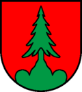
- A green fir tree in red on a green three-mountain
Web links
- Official website of the municipality of Hüniken
- Othmar Noser: Hüniken. In: Historical Lexicon of Switzerland .
Individual evidence
- ↑ Permanent and non-permanent resident population by year, canton, district, municipality, population type and gender (permanent resident population). In: bfs. admin.ch . Federal Statistical Office (FSO), August 31, 2019, accessed on December 22, 2019 .
- ↑ Population growth continues . Press release. Federal Statistical Office . April 26, 2012. Retrieved July 17, 2012.


