Hersiwil
| Hersiwil | ||
|---|---|---|
| State : |
|
|
| Canton : |
|
|
| District : | Water authority | |
| Residential municipality : | Three yards | |
| Postal code : | 4558 | |
| former BFS no. : | 2522 | |
| Coordinates : | 614 869 / 223831 | |
| Height : | 491 m above sea level M. | |
| Area : | 1.41 km² | |
| Residents: | 191 (December 31, 2012) | |
| Population density : | 135 inhabitants per km² | |
| Website: | www.hersiwil.ch | |
|
Hersiwil |
||
| map | ||
|
|
||
Until December 31, 2012, Hersiwil (in the local dialect Hersiwiu ) was a municipality in the Wasseramt district of the canton of Solothurn in Switzerland .
On January 1, 2013, Hersiwil merged with the Heinrichswil-Winistorf municipality to form the new political municipality of Drei Höfe .
geography
Hersiwil is 491 m above sea level. M. , nine kilometers southeast of the canton capital Solothurn (linear distance ). The village extends on a hill in the gently undulating landscape east of the alluvial plain of the Emme , in the southern Solothurn Mittelland .
The area of the 1.4 km² former municipal area includes a section of the moraine landscape in the outer water authority, which was formed by the ice age Rhone glacier . The former municipal soil extends from the hill of Hersiwil to the east into the Aegertenwald , in which at 505 m above sea level. M. the highest elevation of Hersiwil is, and to the west over the valley basin of a side stream of the Ösch to the Rütihof on the edge of the lower forest . In 1997, 7% of the former municipal area was accounted for by settlements, 23% for forests and woodlands and 70% for agriculture.
With the Rütihof, Hersiwil only has a single farm. The neighboring communities of Hersiwil were Horriwil , Aeschi , Heinrichswil-Winistorf , Halt and Oekingen .
population
With 191 inhabitants (as of December 31, 2012), Hersiwil was one of the smallest communities in the canton of Solothurn. 99.4% of the residents speak German and 0.6% speak Portuguese (as of 2000). The population of Hersiwil was 137 in 1850 and 152 in 1900. After a peak in 1910 with 180 inhabitants, the population fluctuated between 140 and 160 people in the course of the 20th century.
economy
Until the second half of the 20th century, Hersiwil was a predominantly agricultural village. Even today, agriculture and fruit growing, as well as cattle breeding and forestry, have an important place in the income structure of the population. Further jobs are available in local small businesses and in the service sector, including in a mechanical engineering company. In the last few decades the village has also developed into a residential community. Many employed people are therefore commuters who mainly work in the regions of Solothurn, Herzogenbuchsee and Bern .
traffic
The former municipality is well developed in terms of traffic, although it is located away from the major thoroughfares; the main access is from Kriegstetten . The nearest connection to the A1 motorway (Bern-Zurich) is around 5 km from the town center. By the bus line of the BSU which the route of Kriegstetten according Steinhofgründe operated Hersiwil is connected to the network of public transport. The new line that was built for the Bern-Olten railway line as part of Bahn 2000 runs through the former municipal area . As a noise protection measure, a 1 km long opencast tunnel was built near Hersiwil.
history
The place was first mentioned in a document in 1324 under the name Hersenwile . Later the names Hersewile (1397), Hersenwil (1444) and Hersiwil (1538) appeared. The place name goes back to the Old High German personal name Herizo and means at the courts of Herizo .
Since the Middle Ages, Hersiwil has been under the rule of hold, with this came to the city of Solothurn in 1466 and was assigned to the bailiwick of Kriegstetten. It was not until the Wyniger Treaty in 1665 that the high level of jurisdiction was transferred from Bern to Solothurn. After the collapse of the Ancien Régime (1798), Hersiwil belonged to the Biberist district during the Helvetic Republic and from 1803 to the Kriegstetten district, which was officially renamed the Wasseramt district in 1988. Hersiwil does not have its own church; it belongs to the parish of Kriegstetten.
Until 1798, Hersiwil formed a double community with the neighboring Heinrichswil. Thereafter, the Dreihofgemeinde Heinrichswil-Hersiwil-Winistorf existed until 1854 , before all three places were raised to politically independent communities. In 2012, preparations for a revival of the common community with Hersiwil began. The new community is called Drei Höfe, based on the past .
coat of arms
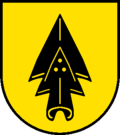
- Yellow black upright double ploughshare with three yellow rivets (in the lower, smaller ploughshare tip)
Attractions
Web links
- Community information
- Othmar Noser: Hersiwil. In: Historical Lexicon of Switzerland .
- Aerial views of the village


