Deitingen
| Deitingen | |
|---|---|
| State : |
|
| Canton : |
|
| District : | Water authority |
| BFS no. : | 2516 |
| Postal code : | 4543 |
| Coordinates : | 614 014 / 229.45 thousand |
| Height : | 430 m above sea level M. |
| Height range : | 419–471 m above sea level M. |
| Area : | 7.60 km² |
| Residents: | 2207 (December 31, 2018) |
| Population density : | 290 inhabitants per km² |
| Website: | www.deitingen.ch |
|
Deitingen taken from a balloon |
|
| Location of the municipality | |
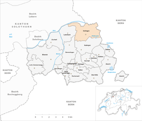
Deitingen (in the local dialect Deitige ) is a municipality in the district Wasseramt of the Canton of Solothurn in Switzerland .
geography
Deitingen is 430 m above sea level. M. , 6 km east of the canton capital Solothurn (linear distance). The village extends on both sides of the Ösch on the gravel plain of the Emme south of the Aare , in the Solothurn Mittelland .
The area of the 7.6 km² municipal area includes a section of the groundwater-rich gravel plain in the water authority. The area has little relief. It is located on the lowest section of the Ösch, in the north it extends partly to the Aare and in the west to the A1 motorway. To the east, the municipality extends to the plateau of the extensive Deitinger forest , in which at 468 m above sea level. M. the highest elevation of Deitingen is reached.
In 1997, 22% of the municipal area was settled, 23% forest and woodland, 54% agriculture, and a little less than 1% was unproductive land.
Deitingen includes the hamlets of Schachen ( 424 m above sea level ) on the Russbach, a side channel of the Ösch, and Wilihof ( 427 m above sea level ) in the plain south of the Aare.
Neighboring communities of Deitingen are Subingen , Derendingen , Luterbach , Riedholz and Flumenthal in the canton of Solothurn and Wangen an der Aare and Wangenried in the canton of Bern .
population
With 2,207 inhabitants (as of December 31, 2018), Deitingen is one of the medium-sized communities in the canton of Solothurn. 94.1% of the residents speak German, 1.2% speak Serbo-Croatian and 1.1% speak Italian (as of 2000). The population of Deitingen was 551 in 1850 and 832 in 1900. During the 20th century there was a continuous increase in population.
history
The first written mention of the place took place in 1244 under the name Teytingen . Later the names Theitingen (1246), Tetingen (1248), Thetingen (1252) and Teitingin (1257) appeared. The place name goes back to the Old High German personal name Teito and means with the ending -ingen as much as with the people of Teito .
Since the 13th century the Lords of Deitingen have been documented, who were successively ministerials of the Counts of Frohburg , the Dukes of Zähringen and the Counts of Kyburg . The family died out in 1435. In 1428, one part of the Deitingen rule came to Solothurn, which from then on exercised lower jurisdiction and appointed a governor. After the second part also went to Solothurn in 1520, Deitingen belonged to the Vogtei Kriegstetten from then on. It was not until 1665 that Solothurn also gained high jurisdiction over the village. After the collapse of the Ancien Régime (1798), Deitingen belonged to the Biberist district during the Helvetic Republic and from 1803 to the Kriegstetten district, which was officially renamed the Wasseramt district in 1988.
Numerous houses were affected by two major fires (1720 and 1869). Only a little later, the industry gained a foothold in the village with the establishment of the first Portland cement factory in Switzerland in 1871. With the opening of the A1 motorway in 1968, the Deitingen service area was opened. Characteristic are the concrete shell roofs ( silver ball ) designed by the engineer Heinz Isler on the Deitingen Süd rest area, which were declared a cultural asset in 1999 and thus saved from demolition.
politics
Municipal council
The executing authority is the municipal council, which consists of seven members and is elected by the people using proportional representation. The term of office is four years. The seven incumbent municipal councils (term of office 2013 to 2017) are:
- Eberhard Bruno (CVP), mayor
- Daniel Schreier (FDP), Vice Mayor
coat of arms
- Divided by white with two black horse heads turned away and by black with a white (diagonally positioned, square) harrow (point upwards)
The horse heads go back to the coat of arms of the Lords of Deitingen.
Culture and sights
The old Catholic parish church of St. Mary was consecrated in 1476. The bell tower, which was given an onion dome in 1707, dates from this time. The nave in the classicism style was rebuilt from 1816 to 1819 and contains an interior from the 19th century, including an altarpiece of the Ascension of Christ. Next to the church is the Antonius Chapel , the former ossuary (restored in 1974). A little outside the village is the former Wasserschlösschen Wylihof , which was built in 1575 and expanded into the so-called Türmlihaus in 1680.
The Deitingen-Süd motorway service station on the A1 motorway between Bern and Zurich is known as a monument to modern engineering . The BP petrol station built by engineer Heinz Isler in 1968 is one of the first large-scale concrete shell constructions .
Sports
The TSV Unihockey Deitingen held every year in Deitingen an indoor floorball tournament for fun teams, the Christmas Cup.
Economy and Infrastructure
Until the first half of the 20th century, Deitingen was a village dominated by agriculture . The water power of the Ösch was previously used to operate a sawmill and a mill. The industrialization held in 1871 in the village of feed a year, was established as the Portland cement factory in Wilihof that their production in 1890 largely to La Reuchenette in Péry moved. From this time on, the supply industry for the watch factories at the southern foot of the Jura developed in Deitingen. Other important companies joined these operations, such as Arthur Flury AG (1919) and companies that manufacture tractors and milking machines.
Even today, agriculture and fruit growing as well as cattle breeding and forestry have a certain place in the income structure of the population. Numerous other jobs are available in industry, in local small businesses and in the service sector. The most important employer is the Vigier Group, which emerged from the former Portland cement factory. In addition, companies in mechanical engineering, electrical engineering, catenary construction, information technology, fine and precision mechanics, the building trade, horticulture and timber construction are located. Gravel pits are exploited in the Deitinger Forest east of the village. A golf course was laid out at the Wilihof. The Schachen Laboratory (founded in 1886) north of the Autobahn is already in the Flumenthal area. It was expanded from 2012-2014 with a new building to become the Solothurn correctional facility with 96 places for closed measures and penal execution.
In the last few decades the village has developed into a residential community. Many workers are commuters who mainly work in the Solothurn region.
traffic
Although the community is located off the main thoroughfares on a connecting road from Derendingen to Wangen an der Aare , it is still well-developed in terms of traffic. The nearest connections to the A1 motorway (Bern-Zurich), which crosses the municipality and was opened in this section in 1968, are each around 5 km from the center at Wangen an der Aare and Zuchwil.
On December 4, 1876, the Gäubahn from Olten to Solothurn was put into operation with a train station in Deitingen.
Personalities
- Urs Eggenschwyler (1849–1923), sculptor
- Dani Fohrler (* 1967), presenter at Swiss television and radio SRF 1 , co-founder of the Solothurn regional broadcaster Radio 32
- Willi Ritschard (1918–1983), politician and Federal Councilor
literature
- Peter Kaiser (Ed.): About the history and landscape of the community Deitingen in the Solothurn water authority . Deitingen community, Deitingen 1994, ISBN 3-9520505-0-4 .
Web links
- Official website of the municipality of Deitingen
- Peter Kaiser: Deitingen. In: Historical Lexicon of Switzerland .
Individual evidence
- ↑ Permanent and non-permanent resident population by year, canton, district, municipality, population type and gender (permanent resident population). In: bfs. admin.ch . Federal Statistical Office (FSO), August 31, 2019, accessed on December 22, 2019 .
- ↑ Hellmut Gutzwiller: Deitingen, from. In: Historical Lexicon of Switzerland .
- ↑ Hans Sigrist: The Lords of Deitingen . In: Yearbook for Solothurn History . tape 33 , 1960, pp. 133-163 , doi : 10.5169 / seals-324175 .
- ↑ P. Kaiser et al .: About the history and landscape of the community Deitingen in the Solothurn water authority (1994), contribution by C. Zumsteg to the church
- ↑ Deitingen-Süd motorway filling station. ( Memento of the original from October 4, 2010 in the Internet Archive ) Info: The archive link was inserted automatically and has not yet been checked. Please check the original and archive link according to the instructions and then remove this notice.
- ^ JVA Solothurn on the website of the Canton of Solothurn , accessed September 17, 2016


