
Etziken
| Etziken | |
|---|---|
 |
|
| State : |
|
| Canton : |
|
| District : | Water authority |
| BFS no. : | 2518 |
| Postal code : | 4554 |
| Coordinates : | 615915 / 226 459 |
| Height : | 479 m above sea level M. |
| Height range : | 453-526 m above sea level M. |
| Area : | 3.37 km² |
| Residents: | 881 (December 31, 2018) |
| Population density : | 261 inhabitants per km² |
| Website: | etziken.ch |
_091.JPG) Etziken |
|
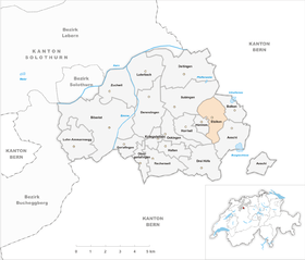
| Location of the municipality | |
  |
|
Etziken (in the local dialect Etzike ) is a municipality in the district of Wasseramt in the canton of Solothurn in Switzerland .
geography

Etziken lies at 479 m above sea level. M. , 9 km east of the canton capital Solothurn (linear distance). The former street village extends on a slope inclined slightly to the northwest between the gravel plain of the Emme in the west and the Önzberg in the east, in the southern Solothurn Mittelland .
The area of the 3.4 km² large municipal area comprises a section of the gently undulating moraine landscape in the outer water office, which was formed by the Ice Age Rhone glacier . The area extends from the Unterwald southward over the plain west of the Inkwilersee and the slope of Etziken up to the heights of Cholholz and Eichwald , on which with 523 m above sea level. M. the highest elevation of Etziken is reached. In 1997, 12% of the municipal area was accounted for by settlements, 32% for forests and woodlands and 56% for agriculture.
Neighboring communities start clockwise from the west: Hüniken , Subingen , Bolken , Aeschi (SO) and Horriwil . All neighboring communities also belong to the Wasseramt district.
A few individual farms belong to Etziken.
population
With 881 inhabitants (as of December 31, 2018) Etziken is one of the smaller communities in the canton of Solothurn. 96.4% of the residents are German-speaking, 0.8% French-speaking and 0.6% speak Italian (as of 2000). The population of Etziken was 546 in 1850 and 490 in 1900. During the 20th century, the population always fluctuated between 450 and 550 inhabitants. Only since 1970 has a significant increase in population been recorded.
economy
Etziken was a predominantly agricultural village until the second half of the 20th century . Even today, agriculture and fruit growing as well as cattle breeding and forestry have a certain place in the income structure of the population. Numerous other jobs are available in local small businesses and in the service sector, including in mechanical engineering, IT, construction and precision engineering workshops. In the last few decades the village has developed into a residential community. Many people in employment are therefore commuters who work mainly in the Solothurn and Herzogenbuchsee regions.
traffic
The community is very well developed in terms of transport. It is located on the main road from Solothurn to Herzogenbuchsee . The nearest connection to the A1 motorway (Bern-Zurich) is around 5 km from the town center.
On June 1, 1857, the railway line from Herzogenbuchsee to Solothurn was put into operation; however, the Etziken stop was not set up until 1927. The line, which was closed in 1992 , is reactivated today as part of Bahn 2000 , but is not used by regional trains. Etziken is connected to the public transport network by the BSU bus line , which serves the route from Solothurn to Herzogenbuchsee.
history
The first written mention of the place took place in 1252 under the name Ezzinchon . Later the names Entzenkon (1329), Ertzenkon (1342), Etzikofen (1356) and Ezikon (1360) appeared. The place name goes back to the Old High German personal name Ezzo . With the name ending -iken (actually a contraction of -igkofen ) it means something like the courts of the people of Ezzo , whereby so-called resettler farms are meant.
In the Middle Ages Etziken formed its own small rule. From the 14th century, part of the area belonged to the Wangen rule. After several changes of ownership, Etziken came under the rule of Solothurn in 1466 and was assigned to the Vogtei Kriegstetten. It was not until the Wyniger Treaty in 1665 that the high level of jurisdiction was transferred from Bern to Solothurn. After the collapse of the Ancien Régime (1798) Etziken belonged to the Biberist district during the Helvetic Republic and from 1803 to the Kriegstetten district, which was officially renamed the Wasseramt district in 1988.
Attractions
In the old town center there are still some characteristic farmhouses from the 18th and 19th centuries. Etziken does not have its own church; it belongs to the parish of Aeschi. The water tower, built in 1931, stands on the forest hill south of Etziken.
coat of arms
- In red on a green Dreiberg white water tower with black window hatches
Web links
- Official website of the Etziken municipality
- Peter Kaiser: Etziken. In: Historical Lexicon of Switzerland .
Individual evidence
- ↑ Permanent and non-permanent resident population by year, canton, district, municipality, population type and gender (permanent resident population). In: bfs. admin.ch . Federal Statistical Office (FSO), August 31, 2019, accessed on December 22, 2019 .
Aeschi |
Beaverist |
Bolken |
Deitingen |
Derendingen |
Three courtyards |
Etziken |
Gerlafingen |
Hold |
Horriwil |
Hüniken |
Kriegstetten |
Lohn-Ammannsegg |
Luterbach |
Obergerlafingen |
Oekingen |
Recherswil |
Subingen |
Zuchwil
Former communities: Ammannsegg | Burgäschi | Heinrichswil | Heinrichswil-Winistorf | Hersiwil | Wages | Steinhof | Winistorf
Canton of Solothurn | Districts of the Canton of Solothurn | Municipalities of the Canton of Solothurn