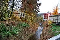
Biberenbach
|
Biberenbach Dorfbach |
||
|
Biberenbach between Lüterkofen-Ichertswil and Bibern |
||
| Data | ||
| Water code | CH : 1277 | |
| location |
Mittelland
|
|
| River system | Rhine | |
| Drain over | Emme → Aare → Rhine → North Sea | |
| source | near Lüterswil-Gächliwil on the high plateau of the central Bucheggberg 47 ° 7 ′ 38 ″ N , 7 ° 26 ′ 38 ″ E |
|
| Source height | approx. 589 m above sea level M. | |
| muzzle | northeast of Biberist in the Emme Coordinates: 47 ° 11 ′ 17 ″ N , 7 ° 34 ′ 25 ″ E ; CH1903: 610233 / 226362 47 ° 11 '17 " N , 7 ° 34' 25" O |
|
| Mouth height | 438 m above sea level M. | |
| Height difference | approx. 151 m | |
| Bottom slope | approx. 10 ‰ | |
| length | 15 km | |
| Catchment area | > 29.45 km² | |
| Right tributaries | Mülibach | |
| Communities | Lüterswil-Gächliwil , Buchegg , Lüterkofen-Ichertswil , Bätterkinden , Biberist | |
The Biberenbach is a 15 km long left tributary of the Emme in the Swiss canton of Solothurn . It drains a section of the hill country of the Bucheggberg in the Solothurn Mittelland and belongs to the catchment area of the Rhine .
geography
course
The source area of the Biberenbach is located at about 600 m above sea level. M. on the parish grounds of Lüterswil-Gächliwil in a hollow on the high plateau of the central Bucheggberg.
The brook initially flows westwards through a small erosion valley and briefly crosses a corner of the Bernese canton. At Gossliwil the Biberenbach draws a sharp curve and now turns to the east-northeast.
In the middle reaches the brook flows through the Biberental , a valley sunk up to 80 m into the molasse heights of the surrounding area with mostly about 400 m wide, flat valley floor. It separates the northern from the southern part of the Bucheggberg and opens at Lohn-Ammannsegg to a wide valley level, which is flanked by the forest heights of Altisberg and Oberwald . Here, the Mülibach, the most important tributary of the Biberenbach, flows from the right . In the area of Biberist the brook reaches the alluvial plain of the Emme , into which it flows north-east of the village at an altitude of 440 m above sea level. M. opens.
Its approximately 15 km long run ends about 151 meters below its source, so it has an average bed gradient of 10 ‰.
Catchment area
The over 30 km catchment area of the Biberenbach lies in the Swiss Plateau and is drained through it via the Emme, Aare and Rhine to the North Sea.
It borders
- in the east to that of the Emme
- in the south to that of the Limpach tributary to the Emme
- in the west to that of the Mülibach , which flows into the Aare
- in the northwest to that of the Leibach , which flows into the Mülibach
- and in the north to that of the Aare.
The catchment area consists of 36.9% wooded area , 53.3% agricultural area , 9.5% settlement area and 0.2% water area.
Area distribution

The mean height of the catchment area is 541 m above sea level. M. , the minimum height is 438 m above sea level. M. and the maximum height at 660 m above sea level. M.
Tributaries
- Eichenbach ( right ), 0.5 km
- Niderholzgraben ( right ), 0.5 km
- Winkelbodengraben ( left ), 0.6 km
- Buchibach ( right ), 0.4 km
- Golterenbach ( left ), 0.4 km
- Bieltschenbach ( right ), 0.8 km
- Lochbach ( left ), 2.5 km, 2.41 km²
- Eichenbach ( right ), 0.4 km
- Ischlagbächli ( right ), 0.5 km
- Fellibächli ( right ), 0.6 km
- Wohlwaldbächli ( right ), 0.3 km
- Talmattgraben ( left ), 1.0 km, 1.15 km²
- Tiefentalbach ( right ), 0.7 km
- Ischbächli ( left ), 0.9 km, 0.68 km²
- Mülibach ( right ), 6.8 km, 9.74 km², 0.26 m³ / s
- Dorfbach ( left ), 2.0 km, 1.32 km²
Hydrology
At the confluence of the Biberenbach into the Emme, its modeled mean flow rate (MQ) is 730 l / s. Its discharge regime type is pluvial inférieur and its discharge variability is 25.

nature and environment
The water quality of the brook is heavily polluted by the intensive agricultural use of the areas in the catchment area, which is why the ammonium and nitrate levels are significantly above the level required for a healthy biological situation. Almost the entire stretch of the Biberenbach was canalized and straightened and the floodplains drained, so that today only a few sections of the upper reaches are preserved in their natural state.
Web links
Individual evidence
- ↑ a b c Geoserver of the Swiss Federal Administration ( information )
- ↑ a b c Topographical catchment areas of Swiss waters: Biberenbach
- ↑ The estuary is directly assigned to the Emme catchment area .
- ↑ a b c d e f g h i j self-measurement
- ↑ "Hidden behind the mean values" - the variability of the discharge regime , p. 119
- ↑ The discharge variability describes the extent of the fluctuations in the mean discharge of individual years around the long-term mean discharge value.

