
Lueterkofen-Ichertswil
| Lueterkofen-Ichertswil | |
|---|---|
 |
|
| State : |
|
| Canton : |
|
| District : | Bucheggberg |
| BFS no. : | 2455 |
| Postal code : | 4571 Lüterkofen 4571 Ichertswil |
| Coordinates : | 605 076 / 223 506 |
| Height : | 473 m above sea level M. |
| Height range : | 466-570 m above sea level M. |
| Area : | 4.43 km² |
| Residents: | 797 (December 31, 2018) |
| Population density : | 180 inhabitants per km² |
| Website: | www.lueterkofen-ichertswil.ch |
 View of Ichertswil |
|
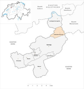
| Location of the municipality | |
  |
|
Lüterkofen-Ichertswil is a municipality in the Bucheggberg district in the canton of Solothurn in Switzerland . The community was created in 1961 through the merger of the formerly independent communities of Lüterkofen and Ichertswil .
geography
The double community Lüterkofen-Ichertswil is located around 6 km south-southwest of the canton capital Solothurn (beeline). Both villages, Lüterkofen ( 473 m above sea level ) and Ichertswil ( 483 m above sea level ) extend in the basin of the Biberenbach in the eastern part of the Bucheggberg , in the Solothurn Mittelland .
The area of the 4.4 km² large municipality covers a section of the Molasse heights of the Bucheggberg. The Biberenbach flows through the area from west to east in a wide valley basin. The Biberental widens west of Ichertswil after a narrow valley to a flat valley floor up to 500 m wide, which merges into an alluvial plain below Lüterkofen. South of the Biberental, the community ban extends to the wooded ridge of the Oberholz (up to 555 m above sea level ), which separates the valley from the Mühletal. To the north, the municipality extends over a gently sloping slope and the hollow from Hinter Grimpach to the plateau of Leuzigenwald and Oberwald . On the Banzenrain above Lüterkofen is 563 m above sea level. M. reached the highest point of the municipality. In 1997, 12% of the municipal area was settled, 34% forest and woodland, 53% agriculture and a little less than 1% was unproductive land.
In addition to the two main settlements of Lüterkofen and Ichertswil, the municipality also has a few individual farms. Neighboring communities of Lüterkofen-Ichertswil are Lüsslingen-Nennigkofen , Lohn-Ammannsegg and Buchegg in the canton of Solothurn and Bätterkinden and Leuzigen in the canton of Bern .
population
With 797 inhabitants (as of December 31, 2018), Lüterkofen-Ichertswil is one of the smaller communities in the canton of Solothurn. 97.7% of the residents are German-speaking, 0.8% French-speaking and 0.3% speak Dutch (as of 2000). The population of Lüterkofen-Ichertswil was 438 in 1850, and 492 in 1900. During the 20th century the population fluctuated between 440 and 520 people. Only since 1970 (528 inhabitants) has a steady population growth been recorded.
economy
Until the second half of the 20th century, Lüterkofen-Ichertswil was predominantly an agricultural village. Even today, arable farming and fruit growing as well as cattle breeding have an important place in the income structure of the population. Further jobs are available in local small businesses and in the service sector. In Lüterkofen-Ichertswil, there are companies in the building trade, horticulture, timber construction, a furniture store and a wine shop. A gravel pit is being exploited above Ichertswil. In the last few decades the village has developed into a residential community through the construction of new quarters on the panoramic southern slope of the Banzenrain. Many employed people are therefore commuters who mainly work in the Solothurn and Grenchen regions.
traffic

The community is very well developed in terms of transport. It is located on the connecting road from Biberist to Schnottwil . On April 10, 1916, the railway line from the Bern-Solothurn regional train with the Lohn-Lüterkofen station was inaugurated. This train station is located in the Lohn-Ammannsegg area around 1 km east of Lüterkofen. The villages of Lüterkofen and Ichertswil are connected to the public transport network through a Postbus course , which covers the route from Lohn-Lüterkofen train station to Schnottwil.
history
The first written mention of the place Ichertswil took place in 1148 under the name Hisenharceswilare . Later the names Ysnatzwile (1399) and Jsserzwil (1540) appeared. The place name goes back to the personal name Isanhart and means at the Isanhart courts . The first mention of Lüterkofen dates from 1315 as Lüterkon . The spellings Lütrikon (1344), Luterkoven (1368) and Lu (i) terkofen (1382) have been handed down from a later period . This village name is derived from the Old High German personal name Liutheri . With the suffix -kofen, it means something like the courts of the people of Liutheri, whereby so-called resettler farms are meant.
Since the Middle Ages, the two localities have been under the rule of Buchegg, which was part of the Landgraviate of Burgundy , acquired by Solothurn in 1391 and converted into the Bucheggberg Bailiwick. Until 1798 the high jurisdiction lay with the Bernese district court Zollikofen , while Solothurn exercised the lower jurisdiction with the place of jurisdiction in Lüsslingen. After the collapse of the Ancien Régime (1798), Lüterkofen and Ichertswil belonged to the Biberist district during the Helvetic Republic and to the Bucheggberg district from 1803. In 1961, the two previously independent municipalities of Lüterkofen and Ichertswil merged to form the new political municipality of Lüterkofen-Ichertswil.
Attractions
Lüterkofen-Ichertswil belongs to the parish of Lüsslingen , but has its own church on the western edge of the village of Lüterkofen.
photos

village street

village street

Old school house

school
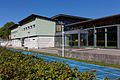
Multipurpose hall

reformed Church

Lohn-Lüterkofen train station


coat of arms
- Split four times by yellow and red; the middle yellow field is covered with three black rafters. The rafters are based on the coat of arms of the Count's House of Neuchâtel-Nidau .
Web links
- Official website of the municipality of Lüterkofen-Ichertswil
- Othmar Noser: Lüterkofen-Ichertswil. In: Historical Lexicon of Switzerland .
- Othmar Noser: Lueterkofen. In: Historical Lexicon of Switzerland .
- Othmar Noser: Ichertswil. In: Historical Lexicon of Switzerland .
Individual evidence
- ↑ Permanent and non-permanent resident population by year, canton, district, municipality, population type and gender (permanent resident population). In: bfs. admin.ch . Federal Statistical Office (FSO), August 31, 2019, accessed on December 22, 2019 .
Biezwil |
Buchegg |
Lüsslingen-Nennigkofen |
Lüterkofen-Ichertswil |
Lüterswil-Gächliwil |
Measure |
Schnottwil |
Unterramsern
Former municipalities: Aetigkofen | Aetingen | Balm at trade fairs | Beavers | Brügglen | Brunnenthal | Gächliwil | Gossliwil | Hessigkofen | Ichertswil | Küttigkofen | Kyburg-Buchegg | Lüsslingen | Lueterkofen | Lüterswil | Mühledorf | Nennigkofen | Oberramsern | Tscheppach
Canton of Solothurn | Districts of the Canton of Solothurn | Municipalities of the Canton of Solothurn