
Unterramsern
| Unterramsern | |
|---|---|
 |
|
| State : |
|
| Canton : |
|
| District : | Bucheggberg |
| BFS no. : | 2463 |
| Postal code : | 4588 |
| Coordinates : | 603 393 / 218 780 |
| Height : | 475 m above sea level M. |
| Height range : | 463–602 m above sea level M. |
| Area : | 1.58 km² |
| Residents: | 218 (December 31, 2018) |
| Population density : | 138 inhabitants per km² |
| Website: | www.unterramsern.ch |
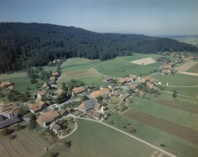 Aerial (1988) |
|
| Location of the municipality | |
  |
|
Unterramsern is a municipality in the Bucheggberg district in the canton of Solothurn in Switzerland .
geography
_161.JPG)
Unterramsern lies at 475 m above sea level. M. , 11 km south-southwest of the canton capital Solothurn (air line). The street village extends at the southern foot of the Bucheggberg , on the edge of the wide plain of the Limpachtal , in the Solothurn Mittelland .
The area of the 1.5 km² municipal area comprises a section of the Molasse heights of the Bucheggberg. The southern border runs along the canalized Limpach. From here, the communal soil extends northwards over the intensively used agricultural level to the adjacent, densely wooded steep slopes of the Bucheggberg. The southern slope of the Chalgen has several short erosion channels . At the edge of the high plateau of the Egg near Aetigkofen is 600 m above sea level. M. reached the highest elevation of Unterramsern. In 1997, 7% of the municipal area was in settlements, 29% in forests and woodlands, 63% in agriculture and a little less than 1% was unproductive land.
Unterramsern includes the western part of the Brittern settlement ( 472 m above sea level ) on the edge of the Limpach valley at the southern foot of the Britterenhubel and some individual farms. Neighboring communities of Unterramsern are Messen , Buchegg in the canton of Solothurn and Limpach and Mülchi in the canton of Bern .
population
With 218 inhabitants (as of December 31, 2018) Unterramsern is one of the smallest communities in the canton of Solothurn. 98.9% of the residents speak German and 0.6% speak French (as of 2000). The population of Unterramsern was 221 in 1850 and 170 in 1900. In the course of the 20th century, the population continued to decrease to 129 people by 1970. Since then, the population has grown again significantly.
economy
Until the second half of the 20th century, Unterramsern was a predominantly agricultural village. Even today, arable farming and fruit growing as well as cattle breeding have an important place in the income structure of the population. Other jobs are available in local small businesses and in the service sector, including in companies in the wood processing and electrical industries. In the last few decades the village has also developed into a residential community. Many employed people are therefore commuters who work mainly in the Solothurn and Bern regions.
traffic
The community is located off the main thoroughfares on a connecting road from Lohn-Ammannsegg along the southern foot of the Bucheggberg to Messen . Unterramsern is connected to the public transport network through a PostBus course , which serves the route from Bätterkinden to Messen, and the Bucheggberg on- call bus .
history
The place was first mentioned in a document in 1276 under the name Rambsern , although it is not clear whether the name refers to Oberramsern or Unterramsern. The place name goes back to the old Swiss German word rams (bear garlic).
Since the Middle Ages, Unterramsern has been under the rule of Buchegg, which was part of the Landgraviate of Burgundy , acquired by Solothurn in 1391 and converted into the Bucheggberg Bailiwick. Until 1798 the high jurisdiction lay with the Bernese district court Zollikofen , while Solothurn exercised the lower jurisdiction with the place of jurisdiction Aetingen. After the collapse of the Ancien Régime (1798) Unterramsern belonged to the Biberist district during the Helvetic Republic and to the Bucheggberg district from 1803.
Attractions
In the center of the village there are some characteristic farmhouses with low hipped roofs from the 18th and 19th centuries. Unterramsern does not have its own church; it belongs to the parish of Aetingen-Mühledorf.
coat of arms
- Divided by red and white, covered with a six-leaf (wild garlic flower) rosette and six circles representing the stamens between the leaves in alternating colors
Web links
- Community information
- Beat Hodler: Unterramsern. In: Historical Lexicon of Switzerland .
- Aerial views of the village
Individual evidence
- ↑ Permanent and non-permanent resident population by year, canton, district, municipality, population type and gender (permanent resident population). In: bfs. admin.ch . Federal Statistical Office (FSO), August 31, 2019, accessed on December 22, 2019 .
Biezwil |
Buchegg |
Lüsslingen-Nennigkofen |
Lüterkofen-Ichertswil |
Lüterswil-Gächliwil |
Measure |
Schnottwil |
Unterramsern
Former municipalities: Aetigkofen | Aetingen | Balm at trade fairs | Beavers | Brügglen | Brunnenthal | Gächliwil | Gossliwil | Hessigkofen | Ichertswil | Küttigkofen | Kyburg-Buchegg | Lüsslingen | Lueterkofen | Lüterswil | Mühledorf | Nennigkofen | Oberramsern | Tscheppach
Canton of Solothurn | Districts of the Canton of Solothurn | Municipalities of the Canton of Solothurn