Brugglen
| Brugglen | ||
|---|---|---|
| State : |
|
|
| Canton : |
|
|
| District : | Bucheggberg | |
| Residential municipality : | Buchegg | |
| Postal code : | 4582 | |
| former BFS no. : | 2446 | |
| Coordinates : | 604 445 / 221498 | |
| Height : | 547 m above sea level M. | |
| Area : | 1.70 km² | |
| Residents: | 200 (December 31, 2013) | |
| Population density : | 118 inhabitants per km² | |
| Website: | www.buchegg-so.ch | |
|
In Brügglen |
||
| map | ||
|
|
||
Until December 31, 2013, Brügglen was a municipality in the Bucheggberg district of the canton of Solothurn in Switzerland . On January 1, 2014, Brügglen merged with the former municipalities of Aetigkofen , Aetingen , Bibern , Gossliwil , Hessigkofen , Küttigkofen , Kyburg-Buchegg , Mühledorf and Tscheppach to form the new municipality of Buchegg .
geography
Brügglen lies at 547 m above sea level. M. , 8 km south-southwest of the canton capital Solothurn (air line). The clustered village extends on a plateau of the eastern Bucheggberg , south of the Mühletal, in the Solothurn Mittelland .
The area of the 1.7 km² municipal area comprises a section of the Molasse heights of the Bucheggberg. The central part of the area forms the high plateau of Brügglen, which descends towards the northeast to a side valley of the Mühletal. To the south of the plateau is the forest height Ämit , on which 620 m above sea level. M. the highest point of Brügglen is reached. To the north, the municipality extends over the middle section of the Mühletal on the forest ridge of the Änerholz (up to 555 m above sea level ), which separates the Mühletal from the Biberntal. In 1997, 5% of the municipal area was accounted for by settlements, 40% by forests and woodlands and 55% by agriculture.
The hamlet of Blumenrüti ( 542 m above sea level ) on the plateau east of the village and several individual farms belong to Brügglen . Up until December 31, 2013, the neighboring communities of Brügglen were Lüterkofen-Ichertswil , Küttigkofen , Kyburg-Buchegg , Aetingen , Mühledorf and Tscheppach .
population
With 200 inhabitants (as of December 31, 2013) Brügglen was one of the small communities in the canton of Solothurn. 98.9% of the residents speak German, 0.5% speak Italian and 0.5% speak Turkish (as of 2000). The population of Brügglen was 181 in 1850 and 188 in 1900. In the course of the 20th century, a slight decrease in population was registered overall. Since 1980 (139 inhabitants) there has been a significant increase in population.
economy
Up until the second half of the 20th century, Brügglen was primarily a village characterized by agriculture . The water power of the Mühlebach was previously used to operate a mill, which was no longer built after a fire in 1909. Even today, arable farming and fruit growing as well as cattle breeding have an important place in the income structure of the population. A few other jobs are available in local small businesses and in the service sector, including in an electronics store. In the last few decades the village has also developed into a residential community. Many employed people are therefore commuters who work mainly in the Solothurn and Bern regions.
traffic
The community is located off the major thoroughfares on a connecting road from Bätterkinden to Mühledorf . Brügglen is connected to the public transport network through a Postbus course , which serves the route from the Lohn - Lüterkofen train station to Schnottwil , as well as the Bucheggberg on- call bus .
history
The first written mention of the place took place in 1248 under the name Bruglon ; from 1323 the name Brügglon has been handed down. The place name goes back to the Middle High German word brügel , a round piece of wood that was used in the past to secure a path.
Since the 13th century Brügglen has been under the rule of Buchegg, which was part of the Landgraviate of Burgundy , acquired by Solothurn in 1391 and converted to the Bucheggberg Bailiwick. Until 1798 the high jurisdiction lay with the Bernese district court Zollikofen , while Solothurn exercised the lower jurisdiction with the place of jurisdiction Aetingen. After the collapse of the Ancien Régime (1798), Brügglen belonged to the Biberist district during the Helvetic period and to the Bucheggberg district from 1803. Brügglen does not have its own church, it belongs to the parish of Aetingen-Mühledorf.
Attractions
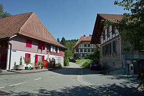
The Ofenhüsli was built around 1800 and was used by the population to bake bread. After a restoration in 1986, it is now occasionally used again. Some characteristic farmhouses from the 18th and 19th centuries have been preserved in the town center.
coat of arms
- Three yellow ears of corn in red on a green three-hill, raised by a shortened, curly yellow rafter


