
Nennigkofen
| Nennigkofen | ||
|---|---|---|
 |
||
| State : |
|
|
| Canton : |
|
|
| District : | Bucheggberg | |
| Residential municipality : | Lüsslingen-Nennigkofen | |
| Postal code : | 4574 | |
| former BFS no. : | 2459 | |
| Coordinates : | 604231 / 226285 | |
| Height : | 456 m above sea level M. | |
| Area : | 4.60 km² | |
| Residents: | 488 (December 31, 2012) | |
| Population density : | 106 inhabitants per km² | |
| Website: | www.nennigkofen.ch | |
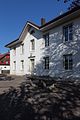
 View towards the Jura |
||
| map | ||
|
||


Nennigkofen was a municipality in the Bucheggberg district of the canton of Solothurn in Switzerland until December 31, 2012 . On January 1, 2013, it merged with Lüsslingen to form the new municipality of Lüsslingen-Nennigkofen .
geography

Nennigkofen is 456 m above sea level. M. , four kilometers southwest of the canton capital Solothurn (linear distance ). The village extends in a hollow of the village stream south of the Aare valley level , in the northernmost foothills of the Bucheggberg , in the Solothurn Mittelland .
The area of the 4.6 km² former municipal area comprises a section of the Molasse heights of the Bucheggberg. The northern border runs along the Aare, which here describes a large arc around the Aare field. From the Aare, the former municipality extends southward over the flat valley plain and the gently undulating ground moraine landscape left behind by the Ice Age Rhone glacier (Hubel, 487 m above sea level ; Riemberg, 458 m above sea level ) to the forest heights of the northern Bucheggberg. The village stream of Nennigkofen rises in the Oberwald and flows into the Aare below Lüsslingen. The highest elevation of Nennigkofen is 551 m above sea level. M. reached on the northern slope of the Lerchenberg . In 1997, 8% of the former municipal area was in settlements, 23% in forests and woodlands, 67% in agriculture and a little more than 2% was unproductive land.
A few individual farms belong to Nennigkofen. Neighboring communities of Nennigkofen were Selzach , Lüsslingen and Lüterkofen-Ichertswil in the canton of Solothurn and Leuzigen in the canton of Bern .
population
With 488 inhabitants (as of December 31, 2012) Nennigkofen was one of the small communities in the canton of Solothurn. 96.9% of the residents speak German, 1.0% speak French and 0.2% speak Italian (as of 2000). The population of Nennigkofen was 406 in 1850 and 433 in 1900. During the 20th century the population fluctuated between 400 and 480 people. Continuous population growth has only been recorded since 1980 (406 inhabitants).
economy
Nennigkofen was a predominantly agricultural village until the second half of the 20th century . The water power of the Dorfbach was previously used to operate a mill and an oil mill. Even today, agriculture and fruit growing, as well as cattle breeding and forestry, have an important place in the income structure of the population.
Numerous other jobs are available in local small businesses and in the service sector. Timber construction, information technology and construction companies are represented in Nennigkofen. The former community is the location of the curling hall for the Solothurn region. In the last few decades the village has also developed into a residential community. Many employed people are therefore commuters who mainly work in the Solothurn and Grenchen regions. The settlement area of Nennigkofen has grown together almost completely today with that of Lüsslingen. The two communities work closely together with regard to infrastructure (school, fire brigade, civil defense).
traffic
The former community is well developed in terms of traffic. It is located on the old main road from Solothurn to Büren an der Aare . In 2002, the Solothurn-Biel section of the A5 motorway was opened, which crosses the former municipal area. The next connection to the motorway is around 3 km east of the town center.
On December 4, 1876, the railway line from Solothurn to Lyss was inaugurated with the Lüsslingen station, which was partly in the area of Nennigkofen; however, the line has now been closed for passenger traffic. Nennigkofen is connected to the public transport network through a post bus course , which covers the route from Solothurn to Büren an der Aare.
history
The first written mention of the place took place in the 14th century under the name Hächelkofen ; from 1368 the name Hechelkofen has been handed down. Since the Middle Ages, the village has been under the rule of Buchegg, which was part of the Landgraviate of Burgundy . In 1375 it was destroyed by the Guglers. It was only given its current name after the subsequent reconstruction. The spellings Nennikofen (1392) and Nennikoffen (1440) were also handed down later . The place name goes back to the Germanic personal name Nanno . With the suffix -igkofen it means something like the courts of the people of Nanno, whereby so-called resettler farms are meant.
In contrast to the other localities of the former Buchegg rule, Nennigkofen remained near Bern in 1391 and only came to Solothurn after the Reformation in 1539, when it was assigned to the Bucheggberg bailiwick. Until 1798 the high jurisdiction lay with the Bernese district court Zollikofen , while Solothurn exercised the lower jurisdiction with the place of jurisdiction in Lüsslingen. After the collapse of the Ancien Régime (1798), Nennigkofen belonged to the Biberist district during the Helvetic and from 1803 to the Bucheggberg district.
In a referendum on September 25, 2011, the voters of Nennigkofen passed the merger with the neighboring municipality of Lüsslingen by a large majority. Since the voters of Lüsslingen also approved this merger, it came into force on January 1, 2013.
Attractions
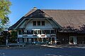
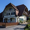
Various farmhouses (typical half-timbered buildings) from the 17th to 19th centuries have been preserved in the old town center. Nennigkofen does not have its own church, it belongs to the parish of Lüsslingen. In the area of Nennigkofen there are two shell stones , both erratic blocks that were brought here from the Valais by the Ice Age Rhone glacier. The Kindlistein, the larger of the two, is located at the Höhlenwäldli north of the village, the second erratic block is on the Hubel.

Local government
school
Weyeneth cultural center
Former oils

Screw factory


coat of arms
- An oblique red bar in yellow, covered with a yellow ear
literature
- Louis Jäggi: The Riemberghof at Nennigkofen . In: Yearbook for Solothurn History . tape 35 , 1962, pp. 206–225 , doi : 10.5169 / seals-324232 .
Web links
- Official website of the community of Nennigkofen
- Thomas Franz Schneider: Nennigkofen. In: Historical Lexicon of Switzerland .
Individual evidence
Biezwil |
Buchegg |
Lüsslingen-Nennigkofen |
Lüterkofen-Ichertswil |
Lüterswil-Gächliwil |
Measure |
Schnottwil |
Unterramsern
Former municipalities: Aetigkofen | Aetingen | Balm at trade fairs | Beavers | Brügglen | Brunnenthal | Gächliwil | Gossliwil | Hessigkofen | Ichertswil | Küttigkofen | Kyburg-Buchegg | Lüsslingen | Lueterkofen | Lüterswil | Mühledorf | Nennigkofen | Oberramsern | Tscheppach
Canton of Solothurn | Districts of the Canton of Solothurn | Municipalities of the Canton of Solothurn