
Lüsslingen
| Lüsslingen | ||
|---|---|---|
 |
||
| State : |
|
|
| Canton : |
|
|
| District : | Bucheggberg | |
| Residential municipality : | Lüsslingen-Nennigkofen | |
| Postal code : | 4574 | |
| former BFS no. : | 2454 | |
| Coordinates : | 604757 / 226 594 | |
| Height : | 439 m above sea level M. | |
| Area : | 3.22 km² | |
| Residents: | 520 (December 31, 2012) | |
| Population density : | 161 inhabitants per km² | |
| Website: | www.luesslingen.ch | |
| map | ||
|
||


Until December 31, 2012, Lüsslingen was a political municipality in the Bucheggberg district of the canton of Solothurn in Switzerland . On January 1, 2013, it merged with Nennigkofen to form the new municipality of Lüsslingen-Nennigkofen .
geography

Lüsslingen lies at 439 m above sea level. M. , three kilometers southwest of the canton capital Solothurn (linear distance ). The village extends in a hollow in the village stream on the southern edge of the Aare valley , at the foot of the Bucheggberg , in the Solothurn Mittelland .
The area of the 3.2 km² former municipal area comprises a section of the Molasse heights of the Bucheggberg. The area is bordered in the north by the course of the Aare, which here draws a large arc around the Aare field . From the flat valley floor, the former municipality extends southward over the Mulde von Lüsslingen to the wooded heights of the northern part of the Bucheggberg. In the so-called Tscheppach-Ischlag is 555 m above sea level. M. reached the highest point of Lüsslingen. The eastern border forms the valley of the Bärenbach , which is slightly cut into the molasse layers . In 1997, 12% of the former municipal area was in settlements, 26% in forests and woodland, 56% in agriculture and a little less than 6% was unproductive land.
Some individual farms belong to Lüsslingen. Neighboring communities of Lüsslingen were Biberist , Lohn-Ammannsegg , Lüterkofen-Ichertswil , Nennigkofen , Selzach and Bellach .
population
With 520 inhabitants (as of December 31, 2012), Lüsslingen was one of the small communities in the canton of Solothurn. 94.4% of the residents speak German, 1.6% speak Albanian and 1.1% speak Arabic (as of 2000). The population of Lüsslingen was 254 in 1850, and 264 in 1900. After a peak in 1960 with 604 inhabitants, the population decreased significantly to 461 people by 1980, and has remained at a constant level since then.
economy

Until the middle of the 20th century, Lüsslingen was a village dominated by agriculture . Today agriculture and fruit growing as well as cattle breeding and forestry have only a minor role in the income structure of the population. Further jobs are available in local small businesses and in the service sector. In Lüsslingen there are companies in the building trade, metal construction, precision engineering workshops, a grain silo and a company that specializes in lightning protection systems. There is a gravel and clay pit on the western edge of the village. In the last few decades the village has developed into a residential community. Many employed people are therefore commuters who mainly work in the Solothurn and Grenchen regions. Today the settlement area of Lüsslingen has grown together almost completely with that of Nennigkofen. In terms of infrastructure (school, fire brigade , civil defense ), the two former municipalities work closely together.
traffic
The former community is well developed in terms of traffic. It is located on the old main road from Solothurn to Büren an der Aare . In 2002, the Solothurn-Biel section of the A5 motorway was opened, which crosses the former municipal area. To protect against noise, a 1.2 km long opencast tunnel was built near the village. The next connection to the motorway is around 2 km east of the town center.
On December 4, 1876, the railway line from Solothurn to Busswil was inaugurated with a train station in Lüsslingen; however, the line has now been closed for passenger traffic. Lüsslingen is connected to the public transport network through a Postbus course , which covers the route from Solothurn to Büren an der Aare.
history
The first written mention of the place took place in 1251 under the name Luslingen . Later the names Livslingen (1275), Lüsselingen (1343) and Lüsslingen (1555) appeared. The place name is derived from the Old High German personal name Liuzilo and means with the suffix -ingen as much as for the people of Liuzilo.
Since the Middle Ages, Lüsslingen has been under the rule of Buchegg, which was part of the Landgraviate of Burgundy . In contrast to the other localities of the rule, the village stayed near Bern in 1391 and only came to Solothurn after the Reformation in 1539, when it was assigned to the Bucheggberg bailiwick. Until 1798 the high level of jurisdiction lay with the Bernese district court in Zollikofen , while Lüsslingen was one of the four places of jurisdiction in the bailiwick. After the collapse of the Ancien Régime (1798), Lüsslingen belonged to the Biberist district during the Helvetic Republic and to the Bucheggberg district from 1803.
Attractions
A church in Lüsslingen from the early Middle Ages has been proven by archaeological excavations. Parts of the early medieval cemetery have been discovered several times during soil research.
The current construction of the parish church of St. Michael was built in several stages between 1652 and 1722.
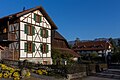
photos
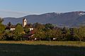
old school house and church
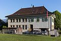
Primary school building
Schulhausweg

Multipurpose hall

Cemetery: same tombstones


coat of arms
- In white on a green plan, green, brown-stemmed and brown-branched linden
Personalities
- Samuel Widmer (1948–2017), doctor, psychiatrist, psychotherapist and author
- Brigit Wyss (* 1960), politician (Greens)
literature
- Municipal administration Lüsslingen (ed.): Lüsslingen - our village in retrospect: 750 years, 1251-2001 . Lüsslingen, 2000
- Louis Jäggi: The church in Lüsslingen . Habegger, 1954
Web links
- Othmar Noser: Lüsslingen. In: Historical Lexicon of Switzerland .
- Official website of the community of Lüsslingen
Individual evidence
- ^ Friedhof_Luesslingen in: Archeology and Monument Preservation of the Canton of Solothurn.
Biezwil |
Buchegg |
Lüsslingen-Nennigkofen |
Lüterkofen-Ichertswil |
Lüterswil-Gächliwil |
Measure |
Schnottwil |
Unterramsern
Former municipalities: Aetigkofen | Aetingen | Balm at trade fairs | Beavers | Brügglen | Brunnenthal | Gächliwil | Gossliwil | Hessigkofen | Ichertswil | Küttigkofen | Kyburg-Buchegg | Lüsslingen | Lueterkofen | Lüterswil | Mühledorf | Nennigkofen | Oberramsern | Tscheppach
Canton of Solothurn | Districts of the Canton of Solothurn | Municipalities of the Canton of Solothurn