Gossliwil
| Gossliwil | ||
|---|---|---|
| State : |
|
|
| Canton : |
|
|
| District : | Bucheggberg | |
| Residential municipality : | Buchegg | |
| Postal code : | 4579 | |
| former BFS no. : | 2449 | |
| Coordinates : | 599 705 / 220 725 | |
| Height : | 539 m above sea level M. | |
| Area : | 1.98 km² | |
| Residents: | 196 (December 31, 2013) | |
| Population density : | 99 inhabitants per km² | |
| Website: | www.buchegg-so.ch | |
|
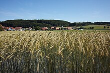
In the center of Gossliwil |
||
| map | ||
|
|
||
Until December 31, 2013, Gossliwil was a political municipality in the Bucheggberg district of the canton of Solothurn in Switzerland . On January 1, 2014, Gossliwil merged with the former communities of Aetigkofen , Aetingen , Bibern , Brügglen , Hessigkofen , Küttigkofen , Kyburg-Buchegg , Mühledorf and Tscheppach to form the new municipality of Buchegg .
geography
Gossliwil lies at 539 m above sea level. M. , eleven kilometers southwest of the canton capital Solothurn (linear distance ). The street village extends in a hollow on the upper reaches of the Biberenbach , on the Bucheggberg , in the Solothurn Mittelland .
The area of the 2.0 km² municipal area covers a section of the Molasse heights of the Bucheggberg. The area is traversed by the Biberenbach in a narrow valley from southwest to northeast. To the south-east of this valley, the municipality extends over the Mülirain to the wooded high plateau of the Bucheggberg, on which at 600 m above sea level. M. the highest point of Gossliwil is reached. To the west, the community area extends over a saddle into the catchment area of the Rütibach. The north-western and northern part is also occupied by a plateau that extends to the edge of the extensive forest areas of Hinterholz and Rütiwald . In 1997, 9% of the municipal area was accounted for by settlements, 33% for forests and woodlands and 58% for agriculture.
Some individual farms belong to Gossliwil. Until December 31, 2013 , neighboring communities of Gossliwil were Bibern , Hessigkofen and Lüterswil-Gächliwil in the canton of Solothurn and Oberwil bei Büren and Rüti bei Büren in the canton of Bern .
population
With 196 inhabitants (as of December 31, 2013), Gossliwil was one of the smallest communities in the canton of Solothurn. 97.3% of the residents speak German, 2.1% speak Albanian and 0.5% speak Portuguese (as of 2000). The population of Gossliwil was 191 in 1850 and 191 in 1900. In the course of the 20th century, a slight decrease in population was registered overall. However, since around 1980 (168 inhabitants) the village has seen an increase in population.
economy
Gossliwil was a predominantly agricultural village until the second half of the 20th century . The water power of the Biberenbach was previously used to operate a mill. Even today, arable farming and fruit growing as well as cattle breeding have an important place in the income structure of the population. A few other jobs are available in local small businesses and in the service sector, including in an assembly shop. In the last few decades the village has also developed into a residential community. Many employed people are therefore commuters who mainly work in the Solothurn and Grenchen regions.
traffic
The community is located off the main thoroughfares on a connecting road from Lohn-Ammannsegg through the Biberental to Büren an der Aare . The closest connection to the A5 motorway is around 5 km from the town center. Gossliwil is connected to the public transport network through a PostBus course , which serves the route from Lohn-Lüterkofen train station to Schnottwil , and the Bucheggberg on- call bus .
history
The municipality of Gossliwil was settled very early on, which has been proven by the remains of several Roman country houses. The place was first mentioned in a document in 1246 under the name Gosseriswile . Later, the names of Goselwyl (1276), Gosselawile (1334) and Goslawile (1349) appeared. The place name goes back to the Old High German personal name Gaushari and means at the courts of Gaushari .
Since the Middle Ages, Gossliwil has been under the rule of Buchegg, which was part of the Landgraviate of Burgundy , acquired by Solothurn in 1391 and converted into the Bucheggberg Bailiwick. Until 1798 the high jurisdiction lay with the Bernese district court in Zollikofen , while Solothurn with the court place Schnottwil exercised the lower jurisdiction. After the collapse of the Ancien Régime (1798), Gossliwil belonged to the Biberist district during the Helvetic and from 1803 to the Bucheggberg district.
Attractions
Several characteristic farmhouses from the 18th and 19th centuries have been preserved in the center of Gossliwil. A granary dates from 1690, the former mill was rebuilt in 1819. Gossliwil does not have its own church, it belongs to the parish of Oberwil bei Büren.
Movies
Gossliwil was the location of the documentary of the same name by Hans Stürm and Beatrice Michel , which thematized rural life in Switzerland. Stürm and Michel lived and worked in Gossliwil from 1982 to 1984 and turned it into a three-hour film, which is one of the central works of Swiss Young Cinema .
coat of arms
- Yellow sheaf standing in red on a green mountain of three, accompanied by three simple five-petalled yellow roses
The roses play on the former affiliation of the village to the Buchegg rule.
Web links
- http://www.gossliwil.ch/ ( Memento from December 30, 2013 in the Internet Archive )
- swisstopo aerial photo from 3 July 1937 of Gossliwil
- Othmar Noser: Gossliwil. In: Historical Lexicon of Switzerland .
Individual evidence


