Brunnenthal SO
| SO is the abbreviation for the canton of Solothurn in Switzerland and is used to avoid confusion with other entries of the name Brunnenthal . |
| Brunnenthal | ||
|---|---|---|
| State : |
|
|
| Canton : |
|
|
| District : | Bucheggberg | |
| Residential municipality : | measure up | |
| Postal code : | 3307 | |
| former BFS no. : | 2447 | |
| Coordinates : | 602341 / 215321 | |
| Height : | 541 m above sea level M. | |
| Area : | 0.91 km² | |
| Residents: | 203 (December 31, 2008) | |
| Population density : | 223 inhabitants per km² | |
|
Brunnenthal SO |
||
| map | ||
|
|
||
Until December 31, 2009, Brunnenthal was a municipality in the Bucheggberg district of the canton of Solothurn in Switzerland . On January 1, 2010, the merger of the municipalities of Balm bei Messen , Brunnenthal, Messen and Oberramsern to form the new municipality of Messen .
geography
Brunnenthal lies at 541 m above sea level. M. , 14 km south-southwest of the canton capital Solothurn (air line). The village extends on a knoll between the Limpachtal in the north and the Mülchibach valley in the east, in the northeastern part of the Rapperswil plateau, in the Solothurn Mittelland .
The area of the former municipality area of just 0.9 km² comprised a section of the ground moraine landscape of the Rapperswil plateau in the extreme southwest of the Solothurn Mittelland. The area extended from the southern edge of the Limpach valley southwards over the height of Brunnenthal to the Mülchibach. Furthermore, two clearing islands belonged to the community as exclaves : Burgsumpf on the plateau (at 543 m above sea level, the highest elevation of Brunnenthal) southwest of the village and castle on the eastern slope of the Messibach. In 1997, 12% of the former municipal area was accounted for by settlements, 9% for forests and woodlands and 79% for agriculture.
Several individual farms belonged to Brunnenthal. Neighboring communities of Brunnenthal were messes in the canton of Solothurn and Mülchi , Etzelkofen and barns in the canton of Bern .
population
With 203 inhabitants (as of December 31, 2008) Brunnenthal was one of the small communities in the canton of Solothurn. 97.4% of the residents speak German and 2.6% speak Dutch (as of 2000). The population of Brunnenthal was 266 in 1850 and 214 in 1900. In the course of the 20th century a further 30% decrease in population to 148 people was registered due to strong emigration up to 1970. Only since 1990 (153 inhabitants) has a significant increase in population been recorded.
economy
Until the second half of the 20th century, Brunnenthal was a village dominated by agriculture . Even today, arable farming and fruit growing as well as cattle breeding have an important place in the income structure of the population. A few other jobs are available in local small businesses and in the service sector, including a painting business. In the valley of the Mülchibach below Brunnenthal there is a clay pit that is exploited by the Etzelkofen brickworks. In the last few decades the village has also developed into a residential community. Many employed people are therefore commuters who work mainly in the Solothurn and Bern regions.
traffic
The village is located off the main thoroughfares on a connecting road from Messen to Fraubrunnen . Brunnenthal is connected to the public transport network through a PostBus course , which serves the route from Jegenstorf train station to Messen.
history
The place was first mentioned in a document in 1396 under the name Brunental . Since it was first mentioned, Brunnenthal was under the rule of Messen, with which it came to the Solothurn Monastery in 1410 and was subsequently assigned to the Bucheggberg Bailiwick. Until 1798 the high jurisdiction lay with the Bernese district court Zollikofen , while Solothurn exercised the lower jurisdiction with the court place Messen. After the collapse of the Ancien Régime (1798), Brunnenthal belonged to the Biberist district during the Helvetic and from 1803 to the Bucheggberg district. Brunnenthal does not have its own church, it belongs to the parish of Messen. With effect from January 1, 2010, Brunnenthal merged with Balm at Messen, Messen and Oberramsern to form the new municipality of Messen.
Attractions
coat of arms
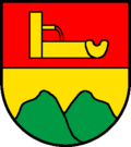
Divided by red with yellow willow well and yellow with green two mountain.
Web links
- Peter Lätt: Brunnenthal. In: Historical Lexicon of Switzerland .
- Aerial views of the village


