
Jegenstorf
| Jegenstorf | |
|---|---|
 |
|
| State : |
|
| Canton : |
|
| Administrative district : | Bern-Mittelland |
| BFS no. : | 0540 |
| Postal code : | 3303 Ballmoos 3303 Münchringen 3303 Jegenstorf 3305 Barn |
| UN / LOCODE : | CH JGT |
| Coordinates : | 605191 / 210999 |
| Height : | 522 m above sea level M. |
| Height range : | 503-585 m above sea level M. |
| Area : | 13.49 km² |
| Residents: | 5746 (December 31, 2018) |
| Population density : | 347 inhabitants per km² |
| Mayor : | Jürg Häberli ( SP ) |
| Website: | www.jegenstorf.ch |
_165.JPG) Jegenstorf |
|
| Location of the municipality | |
  |
|
Jegenstorf ( Bern German Jegischtorf [ ˈjɛgiʃˌtoːrf ]) is a municipality in the Bern-Mittelland administrative district in the canton of Bern in Switzerland . With effect from January 1, 2010, the former Ballmoos municipality merged with Jegenstorf, as did the Münchringen and Scheunen municipalities on January 1, 2014 .
geography

Jegenstorf lies at 527 m above sea level. M. , 12 km north-northeast of the canton capital Bern (linear distance). The scattered village extends in a wide valley at the eastern edge of the plateau of Rapperswil, both sides of the village of Bach , just before its confluence with the Urtenen , in the Swiss Plateau .
The area of the 8.9 km² municipal area comprises a section of the central Bernese plateau with only a weak relief. The eastern part of the municipality lies in the plain of the Urtenen, which partially forms the border. From here, the municipality extends westward into the gently undulating landscape of the Rapperswil plateau, which was shaped by the Ice Age Rhone glacier and has numerous moraine hills , for example the Bimer ( 553 m above sea level ) to the north and the Galgenhoger ( 557 m above sea level ). south of the hollow of the village stream. To the west of this ridge are the formerly swampy areas of Moos , Obermatte and Silberenfeld . These in turn are bounded by the wooded heights of Boll ( 562 m above sea level ), Heschberg ( 557 m above sea level ) and Eichlerenwald . To the west of the Silberenfeld is the height of Ballmoos. At 580 m above sea level M. the highest elevation of Jegenstorf is reached on the forest hill of Buechholz . To the north, the municipal ban extends into the Hambüelwald ( 545 m above sea level ). In 1997, 16% of the municipal area was accounted for by settlements, 20% for forests and woodlands and 64% for agriculture.
Jegenstorf includes extensive new residential areas, the village of Ballmoos and some individual farms. Neighboring communities of Jegenstorf are Deisswil near Münchenbuchsee , Etzelkofen , Fraubrunnen , Hindelbank , Iffwil , Kernenried , Mattstetten , Messen , Rapperswil , Urtenen-Schönbühl , Wiggiswil and Zuzwil .
population
With 5746 inhabitants (as of December 31, 2018) Jegenstorf is one of the medium-sized municipalities in the canton of Bern. 93.6% of the residents speak German, 1.1% speak French and 1.1% speak Albanian (as of 2000). The population of Jegenstorf was 1062 in 1850 and 996 in 1900. In the course of the 20th century, the population increased slowly but continuously to 1,397 people until 1960. Since then there has been a marked increase in population combined with a tripling of the number of inhabitants within 40 years. A particularly strong growth rate was registered between 1960 and 1970, when the population more than doubled.
politics
The voting shares of the parties in the 2015 National Council elections were: SVP 26.2%, SP 18.6%, BDP 17.2%, FDP 11.3%, GPS 7.2%, EPP 7.0%, glp 6.4 %, CVP 2.2%, EDU 2.0%.
economy
Until well into the 20th century, Jegenstorf was predominantly an agricultural village. The craft and trade were always geared towards the needs of agriculture. Only a company for measuring technology founded in 1918 initiated gradual industrialization .
Even today, thanks to the fertile soils, arable farming , fruit growing , dairy farming and cattle breeding have a certain role in the income structure of the population. Numerous other jobs are available in the commercial and service sectors. Since the beginning of the 1970s, companies from various industries have set up shop in industrial zones on the southern and northern outskirts of the village. Today in Jegenstorf there are companies in measurement technology and entertainment electronics ( Interdiscount ), the building trade, the electrical industry, information technology, wood construction, food processing and mechanical workshops.
Jegenstorf fulfills certain central local functions for the surrounding area. It is the seat of a branch of the Valiant Bank and the location of a secondary school. The Fraubrunnen District Hospital, which was opened in 1891 and moved to a new building in 1977, which was expanded in 1990, has been closed since 1999. In the last few decades the village has developed into a residential community. Many employees are therefore commuters who work mainly in the agglomerations of Bern or Solothurn .
traffic

The community has good transport links. It is located on the old main road from Bern to Solothurn . The nearest connection to the A1 (Bern – Zurich) and A6 motorways is around 4 km from the town center. On April 10, 1916, the Zollikofen – Solothurn section of the then Electric Narrow Gauge Railway Solothurn – Bern , which is now operated by the local transport company Regionalverkehr Bern – Solothurn , with a train station in Jegenstorf went into operation. A Postbus course , which serves the routes from Jegenstorf to Messen and to Hindelbank , ensures the fine distribution in public transport .
School system
Jegenstorf has two large school buildings, the Säget school house and the Gyrisberg school house. The majority of students attend the first to fourth grade in the Säget schoolhouse. The minority of the pupils attends these school years in the Gyrisberg schoolhouse. From the 5th grade onwards there is a transfer to the Gyrisberg. During the 6th school year, a decision will be made about transferring to secondary school. The secondary school students continue to visit the Gyrisberg schoolhouse.
history

Eleven burial mounds from the Hallstatt period in the Hurschwald on the border with the Münchringen community, in which rich objects such as ceramics and jewelry were found, as well as the remains of a Roman estate near the village church, bear witness to the early settlement of the community of Jegenstorf.
The first written mention of the place took place in 1131 under the name Igistorf . The names Egistor (1177), Eigistorf (1180), Jegistorf (1220), Egestorf (1223), Yegistorf (1229) and Jegenstorf (1299) appeared later . The place name goes back to the Old High German personal name Ego or Igo and therefore means village of the Ego / Igo .
Since the Middle Ages , the ancestral seat of a ministerial family of the Zähringers , which bore the place name, was located in the village . The rule of Jegenstorf later came under the suzerainty of the Kyburger . As early as 1300, part of the rulership passed to the von Erlach family , but it was not until the 15th century that they took over the entire property. From the 16th to the 18th century there were several changes of ownership.
The sovereignty of the area came from the Kyburgers to Bern in 1406, which Jegenstorf assigned to the Zollikofen district court . After the collapse of the Ancien Régime (1798), the village belonged to the Zollikofen district during the Helvetic Republic and from 1803 to the Fraubrunnen Oberamt, which received the status of an official district with the new cantonal constitution of 1831. In the years 1754 and 1820 Jegenstorf was badly affected by fires. The area changed on January 1, 2010, when the previously independent Ballmoos was incorporated into Jegenstorf.
Attractions
The Reformed Church of St. Maria is a late Gothic hall building built around 1515 , the front tower of which is from the previous building. Particularly noteworthy is the collection of saints, statuses and coats of arms that were painted in the 16th and 17th centuries.
The town's landmark is Jegenstorf Castle , which essentially dates back to the 12th century and was expanded into a baroque country estate around 1720 . In the old town center, numerous characteristic farmhouses in the Bernese country style from the 18th and 19th centuries have been preserved.
photos
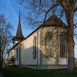
reformed Church

Former tithe barn

Weyenethhaus

Gasthof zum Löwen


Old school houses

Säget schoolhouse

Gyrisberg schoolhouse

Rotonda retirement center (former hospital)


Personalities
Born in Jegenstorf:
- Walter Dürig (* 1927), officer and commander of the Swiss Air Force
- Richard König (1890–1949), politician (BGB) and economist
- Matthias Mischler (* 1990), ice hockey goalkeeper
- Romina Sarina Oprandi (* 1986), tennis player
- Reto Stalder (* 1986), actor and speaker
- Jonas Weingart (* 1986), beach volleyball player
- Cédric Wermuth (* 1986), politician (SP)
- Marlen Reusser (* 1991), cyclist
Died in Jegenstorf:
- Ulrich Niklaus Bernhard König (1914–2011), doctor and politician (NA, Republican)
- Anton Ludwig Stürler (1725–1797), officer and magistrate
- Ludwig Samuel Stürler (1768–1840), architect
Associated with Jegenstorf:
- Lydia Baumgartner (* 1966), City Councilor and Grand Councilor (SP)
- Daniel Wyrsch (* 1963), mayor and councilor (SP)
Web links
- Official website of the municipality of Jegenstorf
- Anne-Marie Dubler : Jegenstorf. In: Historical Lexicon of Switzerland .
- Aerial views of the village
Individual evidence
- ↑ Permanent resident population from STAT-TAB of the BfS , municipalities see also regional portraits 2020 on bfs.admin.ch, accessed on May 29, 2020
- ↑ Elections 2015: Results of the Jegenstorf community. Canton of Bern, accessed on March 19, 2016.
Allmendingen | Arni | Bäriswil | Belp | Bern | Biglen | Bolligen | Bowil | Bremgarten near Bern | Brenzikofen | Clavaleyres | Deisswil near Münchenbuchsee | Diemerswil | Ferenbalm | Fraubrunnen | Frauenkappelen | Open-leaved | Gerzensee | Grosshöchstetten | Guggisberg | Gurbrü | Membranous | Herbigen | Iffwil | Ittigen | Jaberg | Jegenstorf | Kaufdorf | Sweep | Gravel | Kirchdorf | Kirchlindach | Köniz | Konolfingen | Kriechenwil | Landiswil | Laupen | Linden | Mattstetten | Meikirch | Mirchel | Moosseedorf | Mühleberg | Münchenbuchsee | Münchenwiler | Münsingen | Muri near Bern | Neuenegg | Niederhünigen | Niedermuhlern | Oberbalm | Oberdiessbach | Oberhünigen | Oberthal | Oppligen | Ostermundigen | Riggisberg | Rubigen | Rüeggisberg | Rümligen | Rüschegg | Schwarzenburg | Stettlen | Thurnen | Toff | Urtenen-Schönbühl | Vechigen | Forest | Walk rings | Wichtrach | Wiggiswil | Wileroltigen | Wohlen near Bern | Worb | Zziwil | Zollikofen | Zuzwil
Former communities: Aeschlen bei Oberdiessbach | Albligen | Ausserbirrmoos | Ball moss | Perch wall | Belpberg | Bleiken near Oberdiessbach | Bremgarten City Court | Bümpliz | Büren to the yard | Englisberg | Etzelkofen | Gelterfingen | Golats | Grafenried | Gysenstein | Hoods | Innerbirrmoos | Church gymnastics | Limpach | Lohnstorf | Mädersforst | Measure barns | Mühledorf | Mill urns | Mülchi | Münchringen | Niederwichtrach | Noflen | Oberscheunen | Oberwichtrach | Otterbach near Oberdiessbach | Rüti near Riggisberg | Shells | Barns | Schlosswil | Schönthal | Stalden in the Emmental | Tägertschi | Trimstone | Electors | Zauggenried | Zimmerwald
Canton of Bern | Administrative districts of the canton of Bern | Municipalities of the Canton of Bern