
Iffwil
| Iffwil | |
|---|---|
 |
|
| State : |
|
| Canton : |
|
| Administrative district : | Bern-Mittelland |
| BFS no. : | 0541 |
| Postal code : | 3305 |
| Coordinates : | 602995 / 212 542 |
| Height : | 560 m above sea level M. |
| Height range : | 535–606 m above sea level M. |
| Area : | 5.06 km² |
| Residents: | 443 (December 31, 2018) |
| Population density : | 81 inhabitants per km² |
| Website: | www.iffwil.ch |
_165.JPG) Iffwil, photographed from a balloon on April 16, 2011 |
|
| Location of the municipality | |
  |
|
Iffwil is a municipality in the Bern-Mittelland administrative district in the canton of Bern in Switzerland .
geography
Iffwil lies at 560 m above sea level. M. , 13 km north of the canton capital Bern (linear distance). The scattered village extends a scenic location in a shallow high trough in the eastern part of the Rapperswil plateau in the Swiss Plateau .
The area of the 5.0 km² municipal area covers a section of the central Bernese plateau. Between the heights of Mannenbuch and Brattenmoos (at 605 m above sea level, the highest elevation in the community) in the southwest and the Tannwald ( 603 m above sea level ) in the northeast, there is a wide hollow with the settlement center of Iffwil. To the northwest, the municipal ban extends into the moss in the headwaters of the Brandbach , which drains this part to the north via the Mülchibach to the Limpach . In the east, the municipality extends over a gently sloping slope into the Urtenen catchment area , includes the forests of Büelen and Gumpisberg and extends to the edge of the forest of the hill Boll near Jegenstorf. In 1997, 8% of the municipal area was accounted for by settlements, 37% by forests and woodlands and 55% by agriculture.
Iffwil includes the Bergacher residential area ( 580 m above sea level ) on the southern edge of the Tannwald and some individual farms. Iffwil's neighboring communities are Fraubrunnen , Jegenstorf , Rapperswil and Zuzwil (BE) .
population
With 443 inhabitants (as of December 31, 2018), Iffwil is one of the small communities in the canton of Bern. 98.1% of the residents are German-speaking, 0.5% French-speaking and 0.2% speak Spanish (as of 2000). The population of Iffwil was 374 in 1850, compared to 339 in 1900. In the course of the 20th century, the population always fluctuated between 300 and 370 people. Since 1980 (301 inhabitants) there has been a significant increase in population.
politics
The voting shares of the parties in the 2015 National Council elections were: SVP 38.3%, BDP 26.5%, GPS 8.7%, SP 7.2%, FDP 7.0%, glp 4.3%, EPP 3.9 %, EDU 1.8%.
economy
Iffwil was a predominantly agricultural village until the second half of the 20th century . Even today, arable farming , fruit growing , dairy farming and forestry have an important place in the income structure of the population. Further jobs are available in local small businesses and in the service sector. In Iffwil today, among other things, horticultural companies, a garage and a mechanical workshop are represented. In the last few decades the village has developed into a residential community thanks to its attractive location. Many workers are therefore commuters who mainly work in the Bern agglomeration .
traffic
The community is located off the major thoroughfare at the intersection of a connection from Münchenbuchsee to Fraubrunnen and from Jegenstorf to Messen . The nearest connection to the A1 motorway (Bern-Zurich) is around 7 km from the town center. Iffwil is connected to the public transport network by a bus line operated by the RBS , which operates the route from Jegenstorf to Messen.
history

Individual finds from the Neolithic and burial mounds from the Hallstatt period in the Tannwald testify to an early settlement of the community area. The first written mention of the place took place in 1148 under the name Iffenwilere . Later, the names Iffiwiler (1261), Ifwile (1276), Yffewile (1310) and Jffwil (1442) appeared. The place name goes back to the Old High German personal name Iffo and therefore means at the homestead of Iffo .
Iffwil has belonged to the Counts of Kyburg since the Middle Ages . In addition, the Cluniac priory in Rüeggisberg and the Cistercian monastery Frienisberg also owned land in the village. These ownership rights were transferred to the Lower Spital in Bern and the Cistercian convent Fraubrunnen in the 14th century . The documents of Niederiffwil and Oberiffwil still speak of 1356. The latter was on the border with Zuzwil and was probably abandoned around 1400. In 1406 Iffwil came under the sovereignty of Bern and was assigned to the Zollikofen district court . After the collapse of the Ancien Régime (1798), the village belonged to the Zollikofen district during the Helvetic Republic and from 1803 to the Fraubrunnen Oberamt, which received the status of an official district with the new cantonal constitution of 1831.
Attractions
The village has preserved numerous characteristic farmhouses of the Bernese country style from the 18th and 19th centuries. Iffwil does not have its own church; it belongs to the Jegenstorf-Urtenen parish.
photos

Iffwil old cheese dairy

Iffwil bus stop
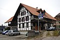
Half-timbered houses in Iffwil
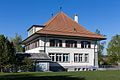
Primary school building

Seniorenhof

Farmhouse
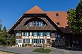
Farmhouse
_110.JPG)
_093.JPG)
_113.JPG)


Web links
- Official website of the municipality of Iffwil
- Anne-Marie Dubler : Iffwil. In: Historical Lexicon of Switzerland .
Individual evidence
- ↑ Permanent resident population from STAT-TAB of the BfS , municipalities see also regional portraits 2020 on bfs.admin.ch, accessed on May 29, 2020
- ↑ Elections 2015: Results of the Iffwil community. Canton of Bern, accessed on March 19, 2016.
Allmendingen | Arni | Bäriswil | Belp | Bern | Biglen | Bolligen | Bowil | Bremgarten near Bern | Brenzikofen | Clavaleyres | Deisswil near Münchenbuchsee | Diemerswil | Ferenbalm | Fraubrunnen | Frauenkappelen | Open-leaved | Gerzensee | Grosshöchstetten | Guggisberg | Gurbrü | Membranous | Herbigen | Iffwil | Ittigen | Jaberg | Jegenstorf | Kaufdorf | Sweep | Gravel | Kirchdorf | Kirchlindach | Köniz | Konolfingen | Kriechenwil | Landiswil | Laupen | Linden | Mattstetten | Meikirch | Mirchel | Moosseedorf | Mühleberg | Münchenbuchsee | Münchenwiler | Münsingen | Muri near Bern | Neuenegg | Niederhünigen | Niedermuhlern | Oberbalm | Oberdiessbach | Oberhünigen | Oberthal | Oppligen | Ostermundigen | Riggisberg | Rubigen | Rüeggisberg | Rümligen | Rüschegg | Schwarzenburg | Stettlen | Thurnen | Toff | Urtenen-Schönbühl | Vechigen | Forest | Walk rings | Wichtrach | Wiggiswil | Wileroltigen | Wohlen near Bern | Worb | Zziwil | Zollikofen | Zuzwil
Former communities: Aeschlen bei Oberdiessbach | Albligen | Ausserbirrmoos | Ball moss | Perch wall | Belpberg | Bleiken near Oberdiessbach | Bremgarten City Court | Bümpliz | Büren to the yard | Englisberg | Etzelkofen | Gelterfingen | Golats | Grafenried | Gysenstein | Hoods | Innerbirrmoos | Church gymnastics | Limpach | Lohnstorf | Mädersforst | Measure barns | Mühledorf | Mill urns | Mülchi | Münchringen | Niederwichtrach | Noflen | Oberscheunen | Oberwichtrach | Otterbach near Oberdiessbach | Rüti near Riggisberg | Shells | Barns | Schlosswil | Schönthal | Stalden in the Emmental | Tägertschi | Trimstone | Electors | Zauggenried | Zimmerwald
Canton of Bern | Administrative districts of the canton of Bern | Municipalities of the Canton of Bern