
Forest BE
| BE is the abbreviation for the canton of Bern in Switzerland and is used to avoid confusion with other entries in the name Wald . |
| Forest | |
|---|---|
 |
|
| State : |
|
| Canton : |
|
| Administrative district : | Bern-Mittelland |
| BFS no. : | 0888 |
| Postal code : | 3086, 3087 |
| Coordinates : | 602 518 / 192 407 |
| Height : | 840 m above sea level M. |
| Height range : | 640–973 m above sea level M. |
| Area : | 13.30 km² |
| Residents: | 1177 (December 31, 2018) |
| Population density : | 88 inhabitants per km² |
| Mayor : | Christian Neuenschwander (EDU) |
| Website: | www.wald-be.ch |
 Englisberg and Zimmerwald |
|
| Location of the municipality | |
  |
|
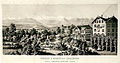
Wald is a municipality in the Bern-Mittelland administrative district in the Swiss canton of Bern . It was created on January 1, 2004 from the merger of the two previously independent communities of Zimmerwald and Englisberg .
geography
Municipal area
Forest is around 840 m above sea level. M. , 8 km south of the canton capital Bern (beeline). The sprawling community extends on the plateau of the northern Längenberg , in a panoramic location around 300 m above the level of the Gürbetal , in the higher Bernese Mittelland .
The area of the 13.3 km² municipal area includes a section of the Längenberg. The area was formed over by the ice of the Aar glacier during the Würm Ice Age and therefore shows largely rounded shapes and moraine deposits in various places . Only the extreme west of the forest area was not covered with ice and has a characteristic relief with numerous short notch valleys and protruding ridges (so-called harrows).
The eastern boundary of the municipality mostly runs on a moraine wall on the eastern slope of the Längenberg. From here, the municipality extends over the Zimmerwald plateau to the forest heights of Lisiberg (at 972 m above sea level, the highest point in the forest), Kühlewilwald and Englisbergwald ( 896 m above sea level ) to the Hubel ( 945 m above sea level) . M. ) before the steep drop to Ulmiztal. To the southwest the area extends over the valley system of the Scherlibach and the height of Tschuggen (up to 940 m above sea level ) to the Mättibach in the catchment area of the Bütschelbach (right inflow of the Schwarzwasser ).
In 1997, 7% of the municipal area was accounted for by settlements, 19% for forests and trees and 74% for agriculture.
Wald's neighboring communities are Kehrsatz , Belp , Toffen , Niedermuhlern , Oberbalm and Köniz .
Districts
The municipality of Wald consists of the following districts:
-
Englisberg ( 820 m above sea level , 377 inhabitants in 2000), in a valley between the Englisbergegg and the Englisbergwald, with the two hamlets
- Kühlewil ( 830 m above sea level ) in a wide hollow west of the Englisberg Forest
- Lower forest ( 872 m above sea level ) on the saddle between Kühlewilwald and Englisbergwald
-
Zimmerwald ( 840 m above sea level , 885 inhabitants in 2000) with the village center and the hamlets
- Willishalten ( 830 m above sea level ) on the eastern edge of the plateau
- At the church ( 856 m above sea level ) south of the village
- Niederhäuser ( 782 m above sea level ) on the eastern slope of the Längenberg
- Winzenried ( 757 m above sea level ) on a moraine wall on the eastern slope of the Längenberg
- Upper forest ( 900 m above sea level ) on the edge of the Kühlewil forest
- Waldhof ( 898 m above sea level ) at the height of the Längenberg
- Obermuhlern ( 860 m above sea level ) at the height of the Längenberg in the headwaters of the Scherlibach
- Egg ( 920 m above sea level ) on the southern slope of the Hubel
- Bumishus ( 905 m above sea level ) at the height south of the Scherlibach valley
In addition, various farm groups and individual farms belong to the forest.
population
With 1177 inhabitants (as of December 31, 2018), Wald is one of the smaller communities in the canton of Bern. 97.7% of the residents speak German, 0.6% French and 0.5% speak Italian (as of 2000). The population of Wald was 1085 inhabitants in 1850 and 1215 in 1900. During the 20th century, the population always fluctuated between 1170 and 1280 people. After a temporary increase to 1342 inhabitants in 1990, a downward trend has been recorded since then.
politics
The voting shares of the parties on the occasion of the National Council elections in 2015 were: SVP 38.9%, BDP 15.3%, SP 13.0%, GPS 7.8%, EDU 6.1%, glp 5.5%, FDP 5.1 %, EVP 4.3%.
Christian Neuenschwander ( EDU ) has been mayor since July 1, 2018 (as of March 2019).
economy
Until the second half of the 20th century, forest was predominantly an agricultural community. Even today, the dairy industry , cattle breeding and forestry have an important place in the income structure of the population. Numerous other jobs are available in local small businesses and in the service sector. Today, horticulture, electrical engineering, car garages and mechanical workshops are represented in Wald. The municipality's most important employer, however, is the Kühlewil retirement and nursing home, which was founded in 1892 as a poor relief institution in Kühlewyl . In the last few decades, the forest has developed into a residential community. Many workers are commuters who mainly work in the agglomeration of Bern.
traffic
The community is located off the main thoroughfares on a connecting road from Kehrsatz over the Längenberg to Riggisberg . Englisberg and Zimmerwald are connected to the public transport network through a post bus course , which covers the route from Wabern to Niedermuhlern.
history
The community of Wald was created through the merger of the previously independent communities of Zimmerwald and Englisberg on January 1, 2004. The new community took on the name of the school community of Wald, which had existed until then, which was borne by Zimmerwald and Englisberg. The name of the school refers to its location in the hamlet of Undere Wald .
Attractions
Zimmerwald Church was built between 1697 and 1699 after Zimmerwald broke away from the parish of Belp. Numerous characteristic farmhouses, stöckli and granaries in the Bernese style from the 18th and 19th centuries have been preserved in all the villages and hamlets of the municipality. Especially in Obermuhlern there is a beautiful group of houses that were built after the village fire of 1780. The former restaurant, which belonged to the Beau-Séjour guesthouse in Zimmerwald, housed a museum for wind instruments until 2009, and since 2010 it has served as a private residence. The main building of the Beau Séjour guesthouse, the so-called villa, in which the Zimmerwald conference took place in 1915 , is now used as a residential building.
Personalities
- Gottlieb Gruner (1756–1830), pastor in Zimmerwald, natural scientist and philanthropist
- Bruno Messerli (1931–2019), geographer
- Niklaus von Tscharner (1935–2016), civil engineer, mayor of Zimmerwald, president of the Society of Pfistern, civic council, director of the Kühlewil home
- Katrin Streit-Eggimann, Grand Councilor
- Kurt Theodor Oehler (* 1942), philosopher, psychologist, author
- Rudolf Joder (* 1950), advocate, national councilor
- Dominique Jann (* 1977), actor
- Mark Streit (* 1977), ice hockey player
- Peter Guggisberg (* 1985), ice hockey player
- Judith Wyder (* 1988), orienteer
photos

Ofenhaus, Englisberg

Zimmerwald village entrance
Hotel and guest house "Beau Séjour", Zimmerwald (1865)

Zimmerwald Church

Zimmerwald church and cemetery
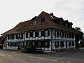
Gasthof Löwen, Zimmerwald

Hamlet Brönni, Niedermuhlern / Wald

Bachmühle, Niedermuhlern / Wald
.jpg)


.jpg)
literature
- Anne-Marie Dubler : Forest (BE). In: Historical Lexicon of Switzerland .
- Anne-Marie Dubler: Englisberg. In: Historical Lexicon of Switzerland .
- Anne-Marie Dubler: Zimmerwald. In: Historical Lexicon of Switzerland .
Web links
Individual evidence
- ↑ Permanent resident population from STAT-TAB of the BfS , municipalities see also regional portraits 2020 on bfs.admin.ch, accessed on May 29, 2020
- ↑ Elections 2015: Results of the community of Wald and Niedermuhlern. Canton of Bern, accessed on March 21, 2016
Allmendingen | Arni | Bäriswil | Belp | Bern | Biglen | Bolligen | Bowil | Bremgarten near Bern | Brenzikofen | Clavaleyres | Deisswil near Münchenbuchsee | Diemerswil | Ferenbalm | Fraubrunnen | Frauenkappelen | Open-leaved | Gerzensee | Grosshöchstetten | Guggisberg | Gurbrü | Membranous | Herbigen | Iffwil | Ittigen | Jaberg | Jegenstorf | Kaufdorf | Sweep | Gravel | Kirchdorf | Kirchlindach | Köniz | Konolfingen | Kriechenwil | Landiswil | Laupen | Linden | Mattstetten | Meikirch | Mirchel | Moosseedorf | Mühleberg | Münchenbuchsee | Münchenwiler | Münsingen | Muri near Bern | Neuenegg | Niederhünigen | Niedermuhlern | Oberbalm | Oberdiessbach | Oberhünigen | Oberthal | Oppligen | Ostermundigen | Riggisberg | Rubigen | Rüeggisberg | Rümligen | Rüschegg | Schwarzenburg | Stettlen | Thurnen | Toff | Urtenen-Schönbühl | Vechigen | Forest | Walk rings | Wichtrach | Wiggiswil | Wileroltigen | Wohlen near Bern | Worb | Zziwil | Zollikofen | Zuzwil
Former communities: Aeschlen bei Oberdiessbach | Albligen | Ausserbirrmoos | Ball moss | Perch wall | Belpberg | Bleiken near Oberdiessbach | Bremgarten City Court | Bümpliz | Büren to the yard | Englisberg | Etzelkofen | Gelterfingen | Golats | Grafenried | Gysenstein | Hoods | Innerbirrmoos | Church gymnastics | Limpach | Lohnstorf | Mädersforst | Measure barns | Mühledorf | Mill urns | Mülchi | Münchringen | Niederwichtrach | Noflen | Oberscheunen | Oberwichtrach | Otterbach near Oberdiessbach | Rüti near Riggisberg | Shells | Barns | Schlosswil | Schönthal | Stalden in the Emmental | Tägertschi | Trimstone | Electors | Zauggenried | Zimmerwald
Canton of Bern | Administrative districts of the canton of Bern | Municipalities of the Canton of Bern