
Gürbetal
| Gürbetal | ||
|---|---|---|
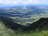
 Panorama of the Gürbe valley seen from the Belpberg . The elongated range of hills behind is the Längenberg . The village of Belp is visible at the very right edge of the picture . |
||
| location | Canton of Bern , Switzerland | |
| Waters | Gürbe | |
| Geographical location | 605 256 / 184.75 thousand | |
|
||

The Gürbetal is a valley in Switzerland and describes a region between Bern and Thun west of the Aare .
geography
The upper part of the valley is in the Thun administrative district , the lower in the Bern-Mittelland administrative district . The valley is named after the river Gürbe . The largest town in the Gürbetal is Belp . The Gürbe and Aare valleys are separated by the Belpberg . To the west, the Gürbetal is flanked by the Längenberg .
The Gürbetal has a flat valley floor one to a maximum of two kilometers wide, on which intensive agriculture is practiced. As a result of the frequent floods, the Gürbe was canalized and the surrounding valley floor drained . This enabled arable and vegetable growing on the fertile soil. Mainly white cabbage ( Chabis in Bern German ) is grown on the fertile black soil, which is processed into suurchabis (sauerkraut) in the factories in Burgistein and Mühlethurnen . The Gürbetal owes its nickname Chabisland to this industry .
Natural park
Most of the Gürbe Valley is now part of the Gantrisch Regional Nature Park . The Gantrisch Nature Park Friends Association has also taken on the tasks of the former Gürbetal Region Transport Association.
The valley is made accessible by the Gürbetalbahn Bern – Belp – Thun, this route is now part of BLS Netz AG . The traffic of the S-Bahn Bern is managed by BLS AG .
gallery

The Gürbetal with Belpberg , seen from the Längenberg near Kaufdorf .
View from the Walalpgrat on the Stockhorn in north direction into the Gürbetal.

The Geistsee in the Gürbetal

The upper Gürbetal in 1925 near Wattenwil u. a. with the Gantrisch in the background. Recorded by the Swiss aircraft pioneer Walter Mittelholzer .


