
Belpberg (mountain)
| Belpberg | ||
|---|---|---|
 The Belpberg |
||
| height | 892.5 m above sea level M. | |
| location | Canton of Bern , Switzerland | |
| Dominance | 3.85 km → Längenberg | |
| Notch height | 297 m ↓ Seftigen | |
| Coordinates | 606 692 / 189940 | |
|
||
| rock | Molasses sandstone and Nagelfluh | |

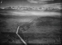
The Belpberg is an isolated ridge in the Aare valley between Bern and Thun in Switzerland . The ridge has a width of 2 up to 4 km and a length of 11 km on, reaches in the Chutzen with 892.5 m above sea level. M. its highest point and rises up to 370 meters from the surrounding valley plains. The Belpberg is delimited in the west by the valley level of the Gürbe , in the east by the broad Aare lowlands and in the north by the Belpmoos , the point at which the Gürbetal flows into the Aare valley. The southern boundary forms a valley furrow at Seftigen . Until 2011 it was in the municipality of Belpberg , which then merged with Belp .
geology
The Belpberg consists of molasses sandstone and Nagelfluh . During the ice ages , the ridge was always completely covered by the ice of the Aare glacier . The geomorphology of the mountain is therefore glacial overprinted. Ground moraine material or lateral moraines were deposited on the ridge and on the slopes during the various stages of retreat of the glacier.
geography
The northern part of the ridge, the Belpberg in the narrower sense, is designed as a wavy plateau, which on average is 800 m above sea level. M. lies. This plateau slopes steeply towards the surrounding area on three sides. The slopes are mostly densely forested and show sandstone rocks in some places . Towards the south, the ridge in the area of the Gerzensee municipality merges into a significantly lower plateau (600 to 650 m above sea level ), on which the Gerzensee with its reeds and bushes is located. This southern part only shows steep slopes towards the Gürbetal, while the ridge slopes gently towards the east. A longitudinal trough begins on this plateau south of Kirchdorf (BE) and is drained from the Limpach to the Aare.
use

The plateau of the Belpberg is mainly used for agriculture. There is extensive meadow and pasture land and arable land as well as numerous fruit trees. The farmers mainly operate dairy farming and cattle breeding , and also arable farming on the fertile soils . The actual ridge is a scattered settlement area (municipality of Belpberg ) with widely scattered hamlets, farm groups and individual farms. On the southern part of the Belpberg are the clustered villages Gerzensee and Kirchdorf (BE) and the scattered settlements of Mühledorf (BE) , Noflen and Kienersrüti . The Belpberg was settled comparatively early, even before the year 1000, because the surrounding valley plains were often hit by floods.
The Belpberg is a popular local recreation area in Bern and the larger towns in the Aare and Gürbe valleys. From the ridge there is a good view of the Bernese Alps .
The Berner Berglaufcoup ("Bärner Bärgloufcoup") is held on the Belpberg, the third stage is a 4.7 km long ascent to the Belpberg, with an altitude difference of 350 meters.