
Bernese Alps
| Bernese Alps | |
|---|---|
 |
|
 Main summit of the Bernese Alps around the Finsteraarhorn |
|
| Highest peak | Finsteraarhorn ( 4274 m above sea level ) |
| location |
|
| part of | Western alps |
| Coordinates | 646 902 / 153 742 |

The Bernese Alps are a mountain group of the western Alps in Switzerland in the cantons of Bern , Valais and Vaud . They form one of the most extensive and outstanding mountain ranges in the Alps between the Bernese Oberland in the north and the Rhone Valley in the south. The Bernese Alps are heavily glaciated. The two longest ice streams in the Alps, the Aletsch and Fiescher glaciers , flow into the Valais on the south side of the Bernese Alps. The highest mountain is the Finsteraarhornwith a height of 4273.9 m. The most famous and most visible is the triumvirate of Eiger , Mönch and Jungfrau .
Demarcation


In the east, the Haslital and Grimsel Pass form the transition to the Urner Alps , in the south the Bernese Alps are bordered by the Rhone Valley . According to a largely uniform view, the border to the north and northwest forms the Hintere Gasse , the distinctive furrow that separates the glaciated Bernese high mountains from the snow-free mountains and their populated valleys in summer. Only the assignment of the wage group in the area of which the furrow does not exist is uncertain. The mountains upstream of the furrow to the north are usually referred to as the Bernese Pre-Alps , in the west also as the Freiburg Pre-Alps and the Vaudois Pre-Alps . The limit in the southwest is unclear. Here the Bernese Alps extend as a uniform mountain range to the lower Rhone Valley near Saint-Maurice . However, because the last mountain groups no longer belong to the canton of Bern on either side, they are often excluded from the term Bernese Alps and referred to as the Vaudois Alps . This applies widely to the groups of the Grand Muveran and the Dent de Morcles , but also in many cases to the group of the Diablerets , which form the border between the cantons of Bern , Vaud and Valais . The SOIUSA classification proposal takes this into account and combines the Vaudois Alps and the Bernese Alps (in the narrower sense) in a superordinate level as the Bernese Alps in the broader sense .
outline
The Bernese Alps are divided into two halves that are both geologically and scenically completely different, the western Bernese Alps and the (eastern) Bernese High Alps. The western Bernese Alps consist of isolated limestone massifs that are a maximum of 3250 m high and only moderately glaciated. This region is characterized by karst plateaus, plateau glaciers and huge karst springs. The western limestone stocks are separated from each other by passes, all of which can be crossed on mule paths ( Sanetsch Pass , Rawil Pass and (in the east) Gemmi Pass ). The Bernese High Alps consist of long, heavily glaciated mountain chains with numerous peaks in the region of 4,000 m. All pass crossings are glaciated here.
The largest part of the Bernese Alps in terms of area is located in the canton of Valais . This applies to the entire southern roof of the Bernese Alps, but also to the Leukertal, the Lötschental and the Aletsch and Fiescher glaciers. Only the northern roof, the Aare glacier and the Gauli basin including the Urbach valley belong to the canton of Bern. The border between Valais and Bern runs essentially across the watershed between Aare and Rhone . The only exceptions are the pass regions of the Sanetsch Pass and Gemmi Pass, which also belong to the Valais north of the watershed. If the western groups are also included in the Bernese Alps, the canton of Vaud also has a small share of the Bernese Alps (northern roofing of the Dent-de-Morcles group, the Muveran group and the Diablerets).
geology
The Bernese Alps are essentially a part of the Aar Massif , that consist of more or less ortsansässigem (autochthonous) crystalline , largely from central Aaregranit , Lauterbrunner granite , amphibolite , gneisses and schists . The Alpine Längstal stretches through the middle of the Bernese Alps , from the Grimsel over the Konkordiaplatz to the Lötschental and on to Leukerbad . In the north-west of the Aarmassiv there is a mantle of Jurassic limestone, which is steeply erected by pressure from the south, and on which the crystalline is even pushed in part. The limestone can be seen most prominently on the Wetterhorn and the Eiger , the thrust of the crystalline on the Jungfrau .
The limestone mantle forms a uniform column of striking peaks, from the Wetterhorn over the Eiger to the Blüemlisalp and on over the Doldenhorn and the Balmhorn to the Gemmi Pass. It is (together with the postponed crystalline pieces) the real showpiece of the Bernese Alps, a huge wall 2 to 3 km high and almost 50 km long, with the Eiger, Mönch and Jungfrau as the centerpiece, which even from the Vosges in 200 Kilometers away can be seen.
The crystalline is closely intertwined with the limestone mantle in the area of the Jungfrau, but further west it is separated from it by the furrow of the Kanderfirn, the Lötschenpass and the upper Dala (Leukerbad). Here the crystalline gradually submerges and disappears together with the limestone mantle under the Rhone Valley.
The western Bernese Alps essentially consist of limestone from the Lower Cretaceous , only in the southern roof over Sion also of Jurassic limestone.
Development and tourism
_-22.JPG)
In the Middle Ages , the passes of the western Bernese Alps served as crossings from the Bernese Oberland to the Valais. A road was laid over the Gemmipass , but it never became important for traffic and is still impassable for cars to this day. The pass regions were used for alpine farming at an early stage, in particular by the German-speaking Alemanni , which is why some peaks there, in otherwise French-speaking surroundings, still bear German names (Rawilhorn, Wetzsteinhorn).
Towards the end of the Middle Ages, the valleys leading into the Rhone Valley were equipped with water pipes that were used to irrigate the dry southern slopes above the Rhone Valley (so-called Bisse or Suonen ).
On the north side only the valleys along the edges of the Bernese Alps ( Lauterbrunnental , Kandertal , Engstligental , Simmental and Saanenland ) were settled (small exceptions in Urbachtal and Stechelberg ), on the south side also the slopes of the mountains and the area around Leuk , the Lötschental and the lower Fieschertal . Most of the mountain range not only remained uninhabited and unused, but also inaccessible and completely unknown.
Konrad Türst's map of Switzerland (approx. 1496) shows some villages on the north and south sides of the Bernese Alps, especially Grindelwald, but otherwise only the route over the Gemmi and not a single mountain peak. The map of Bernischen by Thomas Schöpf (1578) shows in great detail the valleys of the Bernese Oberland, Brigerbad and Leukerbad in the south and the contrast between the foothills and the rugged high peaks, of which the Wetterhorn and Schreck (s) horn , Mettelberg , Eiger and Junckfrau (u) are appropriately designated, as well as the Gemmi with the Daubensee, the seven springs of the Retzliberg and the passes of the western Bernese Alps. By far the largest mountain is the Schreckshorn . The source of the Aare is correctly located beyond the Grindelwald mountains, but there is no evidence of the existence of an Aare glacier or that of all other glaciers.
Later maps showed the region of the Bernese Alps vertically from above for the first time, but did not show any new details of the mountains. They also lack any basic surveying technology, so that the main ridge of the Bernese Alps appears in an east-west direction and Lake Brienz in a NW-SE direction.

On the first scientific mountain panorama of the Alps by Jacques-Barthélemy Micheli du Crest , the Prospect géométrique des montagnes neigées from 1755, the Bernese Alps are clearly recognizable, but still completely inadequately named. Not even Albrecht von Haller was able to give Micheli du Crest the correct names of the mountains. Only the Wetterhorn and Schreckhorn are correctly located there. There are also no other mountain names that were not already included in the map of Schöpf in 1578.
The fringes of the Bernese Alps, especially on the Bernese Oberland side, became a travel destination for poets ( Goethe ) and painters ( William Turner , Samuel Birmann , Caspar Wolf ) in the Baroque and Romantic periods . In particular, the Grindelwald glacier and the Schmadribachfall , Rosenlauigletscher and the Unteraar glacier were considered worth seeing.
With the Atlas Suisse from 1786–1802, the first trigonometrically based map of the Bernese Alps appeared in 1812. It showed numerous peaks with - largely correct - elevations in feet. At the same time, it was the first to contain other, and numerous, mountain names, including the Finsteraarhorn for the first time, and above all the glaciers.
The tourist conquest and thus the geographical discovery of the inner Bernese Alps took place from the Grimsel Pass. Naturalists had their base here as early as the Baroque period, and it is from here that the expeditions to the first ascent of the Jungfrau (1811) and Finsteraarhorn (1812 and 1829) started. At first a mountain lying south of the Mönch was confused with the Jungfrau (so-called Trugberg).
In 1840 Louis Agassiz and others traveled from the Grimsel to the Unteraar Glacier and researched the flow of glaciers for the first time.

The Jungfrau Railway was built in 1894–1912 , which now saves the detour via the Grimsel Pass if you want to go from the Bernese Oberland to the Jungfrau or the Mönch. In 1913 the Lötschberg tunnel was also completed and with it the only continuous traffic connection to date across the Bernese Alps between the Grimsel Pass and Saint-Maurice (today with car transport). Since then, the Lötschental has also been accessible from the north.
In the east of the Bernese High Alps, the KWO power plants were gradually built ( Räterichsbodensee , Grimselsee , Oberaarsee ).
In the 1960s and 1970s, a motorway (national road) was planned over the Rawilpass , which has since been shelved.
On the southern edge of the western Bernese Alps, larger ski areas have emerged, above Crans-Montana , Anzère and Les Diablerets , with the cable cars to the Pointe de la Plaine Morte and Sex Rouge also accessing the summit regions (summer skiing). Smaller ski areas also emerged on the southern edge of the eastern Bernese Alps, for example in Leukerbad, on the Belalp and the Bettmeralp (with Eggishorn ). Wildhorn , Ebnefluh and Rosenegg have been designated as heliports for heli- skiing.
Apart from that, the Bernese High Alps are practically only accessible to hikers and mountaineers to this day; through paths and paths and through huts of the Alpine clubs (especially the SAC), some of which have grown up through spring ski tourism, while others are isolated. The Haute Route of the Bernese Alps from the Grimsel Pass via the Oberaarjochhütte, the Finsteraarhornhütte and Konkordiahütte to the Lötschental and the connection from the Jungfraujoch (Jungfrau Railway) to the Lötschental or the Konkordiahütte are popular with ski mountaineers . In summer, the areas that can be reached from the Jungfrau Railway are also well attended. All other areas, in particular the entire Nesthorn - Bietschhorn group including its valleys leading into the Rhone Valley, are still very lonely. The valley of the Fiescher glacier, through which only delicate path tracks lead, is completely wild and untouched to this day.
A substantial part of this wilderness was designated as a UNESCO World Heritage Site Jungfrau-Aletsch-Bietschhorn in 2001 .
The western Bernese Alps are more intensively developed, especially the wiring and concreting of the mountains around Crans-Montana is noticeable. Apart from the ski areas, however, because there are no roads over the passes, they are still quite natural and a destination for hikers with views of the Valais Alps opposite.
There are excellent long-distance hiking trails both on the northern edge of the Bernese Alps - through Hintere Gasse - and on its southern edge - between the Grimsel and Gemmi passes. The north route is part of the alpine pass route ; both routes are part of the Via Alpina system .
Protected areas
Landscapes of national importance
In accordance with Article 5 of the Federal Act on Nature Conservation and Heritage Protection, Switzerland keeps a federal inventory of landscapes and natural monuments of national importance .
There are currently eight of these landscapes in the Bernese Alps:
- No. 1501, designation: Gelten-Iffigen , year of inclusion in the inventory: 1977, size: 4687 ha, description: Little touched mountain landscape with several imposing waterfalls (Geltenschuss, Dungeluß, Iffigenfalls) and graceful lakes (Lauenensee and Iffigensee). On the Hohberg, a unique example of an upper tree line that has been little influenced by humans and has a particularly rich flora.
- No. 1507, designation: Bernese High Alps and Aletsch-Bietschhorn area (northern part) , year of inclusion in the inventory: 1983, revisions: 1996, size: 49,581 ha
- No. 1513, designation: Engstligenfalls with Engstligenalp , year of inclusion in the inventory: 1996, size: 2488 ha
- No. 1704, designation: Mont d'Orge pres de Sion , year of inclusion in the inventory: 1977, size: 183 ha, description: Free-standing hill with a lake embedded on the north flank. Typical landscape of the Central Valais. Forehead of the Pennine Nappe with sandstones and limestone. On the south side steppe lawns, downy oak and pine stocks with diverse warmth-loving flora and fauna. North slope planted with mixed deciduous forest. Terraced vines. Nice view of the city of Sion and the Rhone plain.
- No. 1705, designation: Valere et Tourbillon , year of inclusion in the inventory: 1977, size: 44ha, description: Two rocky hills rising steeply from the Rhone Valley, dominating the capital of Valais, crowned by historical monuments: ruins of the episcopal castle on tourbillon , Church of Valeria, All Saints Chapel. Xerian plant communities with rare species, i.a. subspontaneous occurrence of Opuntia humifusa.
- No. 1706, designation: Bernese High Alps and Aletsch-Bietschhorn area (southern part), year of inclusion in the inventory: 1983, revisions: 1998, size: 47,306 ha
- No. 1711, name: Raron-Heidnischbiel , year of inclusion in the inventory: 1996, revisions: 1998, size: 276 ha
- No. 1714, designation: Bergij-Platten , year of inclusion in the inventory: 1998, size: 275 ha
summit
Panorama of the Bernese Alps seen from the Faulhorn

The main peaks in an aerial view from the east

Panorama of the Bernese Alps seen from Mount Pilatus

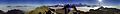
Panorama of the Bernese Alps seen from the Stanserhorn

Panorama of the Bernese Alps seen from Napoleonseck, Watterdingen


The nine four-thousand-meter peaks of the Bernese Alps
- Finsteraarhorn , 4273.9 m
- Aletschhorn , 4195 m
- Virgin , 4158.2 m
- Mönch , 4107 m
- Schreckhorn , 4078 m
- Gross Fiescherhorn , 4048.8 m
- Gross Grünhorn , 4043.5 m
- Lauteraarhorn , 4042 m
- Behind Fiescherhorn , 4025 m
Other important high peaks, classified according to height
- Gletscherhorn , 3983 m
- Eiger , 3967 m
- Äbeni Flue (Ebnefluh), 3963 m
- Agassizhorn , 3946 m
- Bietschhorn , 3934 m
- Gross Wannenhorn , 3905 m
- Klein Fiescherhorn (Ochs), 3895 m
- Mittaghorn , 3892 m
- Nesthorn , 3822 m
- Schinhorn , 3797 m
- Lötschentaler Breithorn , 3785 m
- Lauterbrunner Breithorn , 3780 m
- Sattelhorn , 3745 m
- Balmhorn , 3698 m
- Wetterhorn , 3692 m
- Blüemlisalp , 3661 m
- Doldenhorn , 3638 m
- Altels , 3629 m
- Gspaltenhorn , 3436 m
- Wildhorn , 3248 m
- Wildstrubel , 3243 m
literature
- Sergio Marazzi: Atlante Orografico delle Alpi. SOIUSA . Pavone Canavese (TO), Priuli & Verlucca editori, 2005. ISBN 978-88-8068-273-8 (ital.)
- Sergio Marazzi: La “Suddivisione orografica internazionale unificata del Sistema Alpino” (SOIUSA) - the complete article with detailed illustrations (PDF, Italian; 1.6 MB)
Web links
- Bernese Alps on the ETHorama platform
- Boundary of the Bernese Alps on GeoFinder.ch
Individual evidence
- ↑ Bernese Alps ( Memento from August 1, 2010 in the Internet Archive ) , overview of the SAC guide, stadler-markus.de
- ↑ Eiger, Mönch and Jungfrau as seen from a distance of 200 kilometers from Hohkönigsburg (Château du Haut-Kœnigsbourg) in the Vosges , Wikimedia Commons
