
Urbachtal

The Urbachtal , also called Ürbachtal in the maps since 1998 , is an approximately 10 km long side valley of the Haslital in the eastern Bernese Oberland .
location
The Urbachtal is located south of Meiringen in the upper Haslital. In the west it borders on the Reichenbachtal , from which it is separated by the Engelhörner . In the south are the glaciers that fill the Grimselseen , in the east the Haslital. The steep Engelhorns are part of the Aar massif .
At the top of the Urbachtal is the Gauli Glacier . Its outflow, the Ürbachwasser , flows through the Urbachtal to Innertkirchen , where it flows into the Aare .
From the foot of the glacier, where a glacier lake called Gaulisee has formed, the Ürbach water first flows in a north-easterly direction to the Mattenalpsee at 1874 m. ü. M., where it is jammed. The runoff then makes a U-turn in a north-westerly direction, where it flows for a kilometer. Then it flows past hamlets and alpine huts in a northerly and then northeastern direction to Innertkirchen.
From the Urbachtal, roads and paths lead to Understock , to Loibstock (1621 m) and to Laubalp and the Engelhorn hut of the SAC .
use
The Ürbach water is dammed up as Mattenalpsee to generate electricity. There is a risk of flooding along the entire river bank and, especially in spring, the river becomes a raging meltwater flow . The pastures of the valley are grazed with cows , sheep and goats in summer . Its steep side walls make it a tourist attraction and in summer it is used as a popular barbecue and excursion destination for families and those interested in nature.
Furthermore, the Urbachtal is a training area for the Swiss Army and is therefore regularly partially closed.
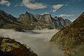
Sea of fog over the Urbach valley and a view of Engelhörner

View of angel horns
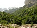
Southern Urbachtal


Individual evidence
- ↑ Geoserver of the Swiss Federal Administration ( information )
Coordinates: 46 ° 40 ′ 18 " N , 8 ° 12 ′ 11" E ; CH1903: 658504 / 169213