Meiringen
| Meiringen | |
|---|---|
| State : |
|
| Canton : |
|
| Administrative district : | Interlaken-Oberhasli |
| BFS no. : | 0785 |
| Postal code : | 3860 |
| UN / LOCODE : | CH MEI |
| Coordinates : | 657 158 / 175 539 |
| Height : | 595 m above sea level M. |
| Height range : | 570–3190 m above sea level M. |
| Area : | 40.63 km² |
| Residents: | 4622 (December 31, 2018) |
| Population density : | 114 inhabitants per km² |
| Mayor : | Roland Frutiger ( independent ) |
| Website: | www.meiringen.ch |
|
View from the Reichenbach Falls to the center of the village, Stein to the right of the Milibach and the Alpbach Falls |
|
| Location of the municipality | |
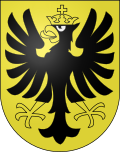
Meiringen , in the Bernese Oberland local dialect Meiringe [mɛi̯rɪŋːə] or an der Gasse [an dər gasːə] , is a municipality in the administrative district of Interlaken-Oberhasli in the Swiss canton of Bern .
geography
Meiringen is located in the eastern Bernese Oberland , in the Haslital on the upper reaches of the Aare , which flows west to Lake Brienz . The place lies at the foot of various passes that allow crossings over the surrounding mountain ranges: in the east the Susten pass into the canton Uri , in the southeast the Grimsel pass in the canton Wallis and in the north-west the Brünig pass in the canton Obwalden . A transition leads through the Reichenbachtal over the Grosse Scheidegg pass to Grindelwald , which is, however, closed to private car traffic.
Meiringen borders in the east on the communities Hasliberg , Innertkirchen and Schattenhalb , in the west on the communities Brienzwiler , Brienz and Grindelwald and in the north on the community Lungern in the canton of Obwalden.
The municipality consists of the villages of Meiringen (north of the Aare ), Balm and Unterheid / Unterbach (south of the Aare), Hausen (towards Brünigpass), Brünigen, Brünig (on the Brünigpass ), Zaun, the Wilerli, the Prasti, the Brünigerälpeli, the Alps Breitenboden, Isetwald, Wandel and Wirzen, Schönbühl and the Schwarzwaldalp , 12.2 kilometers from the village of Meiringen.
Climate table
| Meiringen, 1981-2010 | ||||||||||||||||||||||||||||||||||||||||||||||||
|---|---|---|---|---|---|---|---|---|---|---|---|---|---|---|---|---|---|---|---|---|---|---|---|---|---|---|---|---|---|---|---|---|---|---|---|---|---|---|---|---|---|---|---|---|---|---|---|---|
| Climate diagram | ||||||||||||||||||||||||||||||||||||||||||||||||
| ||||||||||||||||||||||||||||||||||||||||||||||||
|
Average monthly temperatures and precipitation for Meiringen, 1981–2010
Source:
|
||||||||||||||||||||||||||||||||||||||||||||||||||||||||||||||||||||||||||||||||||||||||||||||||||||||||||||||||||||||||||||||||||||||||||||||||||||||
history
The name Meiringen is first mentioned in 1201 when there is talk of a Petrus de Megeringen . The origin of the place name cannot be determined with certainty due to its comparatively late first evidence. It could be formed from the Old High German personal name Megiher and the place name ending -ingun , which would mean "with the people, with the clan of Megiher".
In Meiringen there were two large village fires in 1879 and 1891.
population
| Population development | |||||||||||||
|---|---|---|---|---|---|---|---|---|---|---|---|---|---|
| year | 1764 | 1850 | 1880 | 1900 | 1930 | 1950 | 1960 | 1970 | 1980 | 1990 | 2000 | 2010 | 2015 |
| Residents | 964 | 2,358 | 2,807 | 3,077 | 3,103 | 3,640 | 3,749 | 3,759 | 4,072 | 4,346 | 4,803 | 4,729 | 4,737 |
politics
In Meiringen there is a community meeting that meets properly twice a year. The executive body is the municipal council , which consists of seven members. The mayor is Roland Frutiger (as of 2017).
The voting shares of the parties in the 2015 National Council elections were:
SVP 44.3%, SP 16.8%, BDP 10.9%, GPS 10.2%, FDP 6.7%, glp 3.4%, EVP 1.7%, EDU 1.8%, CVP 0 , 8%, pirates 0.8%.
Attractions

Meiringen is known for the nearby tourist attractions Aare Gorge and the Reichenbach Falls , the latter of which can be reached on foot or by funicular . In the largest cascade of the Reichenbach Falls, the fictional character Sherlock Holmes, created by Arthur Conan Doyle , and Professor Moriarty are said to have fallen on May 4, 1891. However, Holmes survived and took the opportunity to stage his own death and later hunt down the unsuccessful gunman Moran.
At the battle site, which is clearly marked with a white star and to which an approx. 20-minute walk leads from the mountain station of the funicular, a memorial plaque reminds of this (fictional) incident. It reads in English and German: “In this terrifying place, Sherlock Holmes defeated Professor Moriarty on May 4, 1891.” The plaque was created in 1991 by the two Sherlock Holmes societies “The Bimetallic Question of Montreal” and “The Reichenbach Irregulars », The Swiss Holmes Society. There has also been a Sherlock Holmes Museum under the English Church since 1991 and a Sherlock Holmes memorial on the main street, created by John Doubleday . In the museum, the detective's living room at 221B Baker Street, London has been recreated in great detail. The "Sherlock Holmes Society of London" organizes regular trips to Meiringen, where the participants in historical costumes re-enact the adventures of Sherlock Holmes.
On the side of the valley opposite the Reichenbach Falls is the Alpbach Gorge , which also has a waterfall and can be climbed on a rock path.
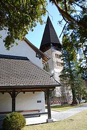
Another attraction is the St. Michaels Church from 1684 with an octagonal free-standing bell tower and its excavations. The whole area of the church is under federal protection. Guided tours are offered regularly.
In the old week of the year , between Christmas and New Year's Eve, the tryeling takes place every year .
Culture
Ubersitz
See also → Haslitaler Tryelte
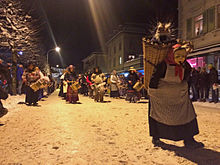
In the week between Christmas and New Year's Eve, the Trychlers are out and about in Haslital . On the last working day of the year, the Trychel trains from the various villages meet at Ubersitz in Meiringen. The Trychlers are mostly disguised. The groups with tryels of different sizes, bells and drums move through the village, each to its own slow rhythm. The old tradition aims to drive away evil spirits.
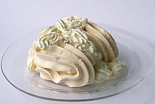
Meringue

According to popular opinion, the Italian confectioner Gasparini in Meiringen is said to have created a dessert from sugar and egg whites for the first time around 1600 (or 1720?), Which he named after the village, and Meiringen is said to have become meringue in French . French colonialists exported it to Haiti - the colonial island was the country's main supplier of sugar. There, in the middle of the 19th century, the sweet dish is said to have given its name to the Caribbean dance in the Dominican Republic , the merengue . In Germany this sweet is better known under the name meringue (French for "kiss"), which is said to go back to an exclamation from the English queen.
These speculations are not tenable, although the term meringue is actually difficult to interpret. In any case, the word was first mentioned in a French cookbook from 1691. According to one interpretation, meringue is said to go back to Middle Latin melinus , which means “honeyed” and is derived from the Latin mel “honey”. According to another, it comes from the Latin merenda, which means "snack, snack". If this second explanation applies , it would be linguistically identical to Marend, the Bündner word for Zvieri (snack in the afternoon - at four o'clock).
Healthcare
Since 2007, Meiringen has had a health center without 24-hour emergency care instead of an acute hospital . An emergency station is available during the day, during the night the local rescue service with ambulance takes over this function. It belongs to the clinic network of the FMI hospitals (Spitäler Frutigen, Meiringen, Interlaken).
The Meiringen Private Clinic has existed since 1919 .
traffic
The central train resulting from the merger of 1 January 2005 Lucerne-Stans-Engelberg train and Brünigbahn originated, has since 1888 in Meiringen a railway terminus in which the route along the Lake Brienz from Interlaken and the rack railway over the Brünigpass from Meet Lucerne . The Reichenbach Falls with the Reichenbach Falls Railway and the Aare Gorge could be reached between 1912 and 1956 with the Meiringen-Reichenbach-Aare Gorge tram . The Meiringen-Innertkirchen-Bahn has also been connected to the Aare Gorge since 1946 .
The cable car from Meiringen provides direct access to the Hasliberg ski area , which has 18 lifts and 60 km of groomed slopes.
Meiringen is on the main road 6 and 11 , which when coming from Interlaken leads to the Susten (No. 11) or the Grimsel Pass (No. 6). Furthermore, main road 4 begins or ends in Brienzwiler west of Meiringen over the Brünig Pass, which is connected to Meiringen by a spur road.
The Meiringen military airfield of the Swiss Air Force is about five kilometers down the valley .
Partnerships
Meiringen has four Swiss partner communities: Eschenbach in the canton of St. Gallen, Le Landeron in the canton of Neuchâtel, Morcote in the canton of Ticino and Scuol in the canton of Graubünden.
Personalities
- Peter im Baumgarten (1761–1799) was a shepherd boy who was taken in in 1775 by Heinrich Julius von Lindau as a foster son ("Peter Lindau called im Baumgarten") and then in 1776 by his friend Johann Wolfgang von Goethe as a ward and foster son.
- Arnold Glatthard (1910–2002), ski racer, mountain guide and politician, mayor 1967–1970, honorary citizen
- Ruth von Fischer (1911–2009), artist and drawing teacher
- Karl Glatthard (1913–1982), national councilor, sports association president
- Andreas Lindt (1920–1985), theologian and professor at the University of Bern; Nephew of Karl Barth
- Christian Menn (1927–2018), civil engineer
- Rudolf Jaun (* 1948), military historian
- Christine Schraner Burgener (* 1963), diplomat, ambassador
- Sascha Urweider (* 1980), racing cyclist
- Kaspar von Grünigen (* 1982), jazz musician
- Matthias Glarner (* 1985), wrestler, wrestling king 2016
- Stefan Glarner (* 1987), soccer player, FC Thun
literature
- Anne-Marie Dubler : Meiringen. In: Historical Lexicon of Switzerland .
- Daniel Wolf, Jost von Allmen: Ernst E. Anderegg . Selected buildings in the Interlaken-Oberhasli region. (= Swiss Art Guide, No. 887/888, Series 89). Edited by the Society for Swiss Art History GSK. Bern 2011, ISBN 978-3-85782-887-4 .
Web links
Individual evidence
- ↑ Permanent resident population from STAT-TAB of the BfS , municipalities see also regional portraits 2020 on bfs.admin.ch, accessed on May 29, 2020
- ^ Linguistic Atlas of German-speaking Switzerland , Volume V, Map 1b.
- ↑ Climate table. In: meteoschweiz.admin.ch. meteoschweiz, accessed on May 31, 2018 .
- ↑ Lexicon of Swiss municipality names . Edited by the Center de Dialectologie at the University of Neuchâtel under the direction of Andres Kristol. Frauenfeld / Lausanne 2005, p. 585.
- ^ Meiringen Online: community meeting. Retrieved October 8, 2017 .
- ^ Meiringen Online: Municipal Council. Retrieved October 8, 2017 .
- ^ Meiringen Online: members of the authorities. Retrieved October 8, 2017 .
- ^ Canton of Bern: Election platform. Retrieved October 8, 2017 .
- ↑ Ubersitz. In: Meiringen municipality. Retrieved January 4, 2015 .
- ↑ Christoph Landolt : Meringue , in: Wortgeschichte from June 20, 2013, published by the Swiss Idiotikon .
- ^ Peter Stettler: Glatthard, Karl. In: Historical Lexicon of Switzerland . November 18, 2005 .


