
Beatenberg
| Beatenberg | |
|---|---|
 |
|
| State : |
|
| Canton : |
|
| Administrative district : | Interlaken-Oberhasli |
| BFS no. : | 0571 |
| Postal code : | 3803 Beatenberg 3800 Sundlauenen |
| Coordinates : | 627 219 / 171940 |
| Height : | 1155 m above sea level M. |
| Height range : | 558-2063 m above sea level M. |
| Area : | 29.25 km² |
| Residents: | 1195 (December 31, 2018) |
| Population density : | 43 inhabitants per km² |
| Website: | www.beatenberg.ch |
 Beatenberg from the air |
|
| Location of the municipality | |
  |
|
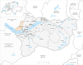
Beatenberg is a municipality in the Interlaken-Oberhasli administrative district in the canton of Bern in Switzerland .
geography
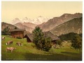
Beatenberg is located in the Bernese Oberland on a terrace below the southern slope of the Niederhorn and high above Lake Thun . The Jungfrau Group ( Eiger , Mönch , Jungfrau ) can be seen particularly well from Beatenberg . The village of Sundlauenen , which is close to the Beatushöhlen directly on Lake Thun , also belongs to the political community of Beatenberg . In addition to individual farms, the community also consists of the burger farmers, the so-called Gütergemeinden, Schmocken, Spirenwald and Waldegg. Neighboring communities are Eriz , Habkern , Horrenbach-Buchen , Sigriswil and Unterseen .
history
Early medieval graves were found in the area of Balmfluh-Beatushöhlen. The first written mention of today's village Beatenberg goes back to the year 1230, it was related to the expanded pilgrimage chapel of the Beatus Cave. The church set went to Interlaken in 1263 and 1334 . The first gentlemen of Rothenfluh then exercised their powers; But the village of super rupes underwent numerous changes in ownership until 1275. Then the properties were transferred to “ King Rudolf of Habsburg and the Empire” through an exchange between the Eschenbachers . In 1281 the place was called ob den fluen and in 1357 it was called Sant Beaten berge . In 1318 Beatenberg came to the Weissenau lordship as pledge, which fell to the Interlaken Monastery in 1334. The farmers Spirenwald, Schmocken and Waldegg-Rufenen had common lands as well as common Alps. In 1394 and 1409 there were disputes over grazing rights; In 1535 the boundaries between the farmers could definitely be determined. The former manorial Alps, which were lent to locals, are now owned by Alpine cooperatives. In 1439 a devastating plague raged in the city of Bern; For this reason, an appeal was made to the Beatushöhle near Sundlauenen . At the cave there was a pilgrimage chapel in honor of the saint, which was subordinate to the Interlaken monastery.
During the Reformation in 1528, the Bernese government had the Interlaken monastery incorporated into the secular bailiwick, the Beatus Chapel torn down and the cave entrance walled up to prevent pilgrimages. The Catholic Unterwaldners did not allow themselves to be deterred from further pilgrimages and broke open the wall again; so the walling up and breaking up went on several times. As a counterweight to the cult around the Beatus Caves, the Bern government had a new Protestant-Reformed wooden church built on the Beatenberg from 1534 to 1540.
In 1535 the Bäuert Waldegg-Rufenen von Goldswil was assigned to the Beatenberg Church. In 1565 the plague also struck Beatenberg; 114 people died within just 6 months. The current church dates from 1673. From 1748 to 1822 Sundlauenen was temporarily added to Unterseen by the church. In 1762 Beatenberg was assigned to the Unterseen City Office and in 1803 to the Oberamt (today: District) Interlaken.
From the 18th century, wool spinning brought additional income to mountain farming. Hard coal was mined above Beatenberg in 1771 on the Gemmenalp and in 1795 on the Niederhorn; the mining was stopped in 1856. The first school buildings were built in Spirenwald, Schmocken, Waldegg and Sundlauenen-Ruchenbühl from 1822 to 1829; The secondary school has been in Spirenwald since 1957. In 1851 the Bernese state ceded its high forest to the farmers.
Spa guests were first received in the rectory, and from 1866 hotels and guesthouses were built that had flourished as luxury hotels by 1914. In 1865 Beatenberg got a road to Interlaken, in 1884 the Seestrasse, in 1889 the Thunersee-Beatenberg cable car and in 1905 the Sundlauenen ship station. In 1904 the Beatus Cave was made accessible to visitors again. From 1913 onwards, Beatenbucht was the end point of the right Thunerseebahn , which was extended to Interlaken in 1914. This was the first time Sundlauenen was connected to public transport. In 1939 the operator switched the railway between Beatenbucht and Interlaken to bus operation, and the Thun – Beatenbucht trolleybus ran on the remaining section from 1952 to 1982 . In 1946 construction began on the Beatenberg – Niederhorn chairlift . This chairlift was replaced in 1996 by a group lift, which was put into operation in 1997. In 1934 the Biblical Home was built, which is now called the Beatenberg Seminar for Biblical Theology and also accommodates guests. Around 1960 the crisis in tourism was overcome by excursion traffic, spa operations, the construction of holiday apartments and ski lifts. The catholic church was built in 1969, a congress building in 1971. A majority of the jobs today are in the service sector, the Balmholz quarry is the only large industrial enterprise.

population
| Population development | |||||||||||||
|---|---|---|---|---|---|---|---|---|---|---|---|---|---|
| year | 1764 | 1850 | 1880 | 1900 | 1930 | 1950 | 1960 | 1970 | 1980 | 1990 | 2000 | 2012 | 2016 |
| Residents | 547 | 1,075 | 1,119 | 1,082 | 1,088 | 1,323 | 1'303 | 1,263 | 1,176 | 1,373 | 1,279 | 1,246 | 1,297 |
Attractions
- Beatushöhlen : According to legend, the local saint Beatus , a missionary from Ireland , moved to Lake Thun and drove a kite out of the caves above Sundlauenen . His abode in the Dragon Cave became a place of pilgrimage. Even today, the kilometer-long stalactite cave with underground lakes is a main attraction of the community.
- In the western part of Beatenberg is the artillery plant Waldbrand , a fortress that was started in 1941 and was ready to fire in 1944.
- Above Lake Thun is the almost 2000 meter high Niederhorn . The view extends from the Bernese Alps with the Eiger , Mönch and Jungfrau to the distant Jura . The Niederhorn is an ideal starting point for shorter and longer hikes. With a little luck you will come across a colony of ibex. The Niederhorn also has its charm in winter: there are ski slopes, winter hiking trails, snowshoe trails and toboggan runs available. A winter hiking trail to the Beatenberg district of Waldegg leads through snow-covered forests and mountain landscapes.

Old farmhouse in Beatenberg

Mural Beatus and the Dragon

reformed Church

Catholic Church

Niederhornbahn AG funicular railway

3-rope group gondola lift operated by Niederhornbahn AG

Beatenberg with Hotel Silberhorn around 1900
Beatenberg around 1900

Beatenberg 1954 with Stockhorn in the background


Personalities
- Albert Samuel Gatschet (1832–1907), ethnologist and linguist, born in Beatenberg
- Erich von Däniken (* 1935), non-fiction author, lives in Beatenberg
- Beatrice Gafner (* 1964), ski racer, born in Beatenberg
- Evelyne Binsack (* 1967), mountain guide, lived in Beatenberg
- Thomas Ulrich (* 1967), adventurer, lives in Beatenberg
- Tim Grossniklaus (* 1995), ice hockey player, born in Beatenberg
Web links
- Official website of the municipality of Beatenberg
- Anne-Marie Dubler : Beatenberg. In: Historical Lexicon of Switzerland .
- Information and pictures about Beatenberg
Individual evidence
- ↑ Permanent resident population from STAT-TAB of the BfS , municipalities see also regional portraits 2020 on bfs.admin.ch, accessed on May 29, 2020
- ↑ Roger Probst: Sigriswiler did not defend themselves against the Reformation , Berner Zeitung, Bern May 11, 2017
- ↑ Thomas Batschelet, CH-2505 Biel / Bienne: 75.008 Beatenberg - Niederhorn, Beatenberg, group cable car cabins. Retrieved May 7, 2017 .
- ^ Anne-Marie Dubler : Beatenberg. In: Historical Lexicon of Switzerland .
Beatenberg | Bönigen | Brienz | Brienzwiler | Därligen | Grindelwald | Gsteigwiler | Gündlischwand | Guttannen | Habkern | Hasliberg | Hofstetten near Brienz | Innertkirchen | Interlaken | Iseltwald | Lauterbrunnen | Leissigen | Lütschental | Mats near Interlaken | Meiringen | Niederried near Interlaken | Oberried am Brienzersee | Ringgenberg | Saxeten | Shadow half | Schwanden near Brienz | Unterseen | Wilderswil
Former parishes: Ebligen | Gadmen | Goldswil | Isenfluh
Canton of Bern | Administrative districts of the canton of Bern | Municipalities of the Canton of Bern