
Isenfluh
| Isenfluh | ||
|---|---|---|
 |
||
| State : |
|
|
| Canton : |
|
|
| Administrative district : | Interlaken-Oberhasli | |
| Residential municipality : | Lauterbrunnen | |
| Postal code : | 3822 | |
| UN / LOCODE : | CH | |
| Coordinates : | 635 108 / 163296 | |
| Height : | 1081 m above sea level M. | |
| Area : | 24.0 km² | |
| Residents: | 62 (March 31, 2009) | |
| Population density : | 3 inhabitants per km² | |
| Website: | www.lauterbrunnen.ch | |
| map | ||
|
||


Isenfluh was an independent municipality until 1973 and is now a district of Lauterbrunnen in the Interlaken-Oberhasli administrative district of the canton of Bern in Switzerland . The small village lies above the Wilderswil -Lauterbrunnen road .
history
Isenfluh was first mentioned in writing as Ysenfluo in 1319 . It is believed that it was a Celtic settlement and that the hamlet of Sulwald was settled first. In Isenfluh, the arrival of Lötschentaler was recorded for the first time in 1401 . The dialect differs significantly from that of the other valley villages. The Interlaken Monastery had owned this small place since the 14th century. From 1528 onwards it was administered by the Landvogtei Interlaken for 270 years.
It was not until 1905 that a simple footpath was built to Lauterbrunnen. Before there was only one connection to Gündlischwand . At the end of the 1950s / beginning of the 1960s, after the footpath was buried, "the street of the youth" was built. Young people, schoolchildren and apprentices spent one to several weeks there and built this road down into the valley by labor.
In 1962/63 the solid, asphalt road was built. In 1965 the first problems arose. The first cracks in the slope made minor repairs necessary. In July 1987 a landslide destroyed this important link and the village was isolated. Thanks to a hastily built emergency cable car, the village could be reached again. In 1992 the village was reconnected to the road network. Thanks to a unique, 1200-meter-long, 360-degree spiral tunnel , the village can again be reached safely by car.
A cable car has been in operation since 1975, connecting Isenfluh with the hamlet of Sulwald.
Residents
| year | 1764 | 1799 | 1850 | 1880 | 1900 | 1920 | 1930 | 1941 | 1950 | 1960 | 1972 | 1980 | 1990 | 2006 |
| Residents | 80 | 107 | 162 | 176 | 145 | 118 | 98 | 68 | 92 | 65 | 42 | 54 | 58 |
Isenfluh suffered from heavy emigration from 1880 onwards. Preferred areas were Canada and the Caucasus .
politics
Isenfluh belongs together with Wengen , Mürren , Gimmelwald , Stechelberg and Lauterbrunnen to the political municipality Lauterbrunnen .
tourism
Isenfluh is the starting point for hikes and toboggan rides. The Suls-Lobhornhütte of the Swiss Alpine Club SAC can be reached from Isenfluh in a few hours. A small cable car takes you to the hamlet of Sulwald at 1520 m. Sulwald is inhabited all year round.
photos

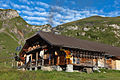
Typical house and Fluh
Sennhütte Sulalp

Karst fields and Sulegg

Sulsseewli
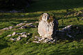
Place of power: Chüebodmiblock
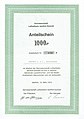
Share certificate of the Isenfluh-Sulwald aerial cableway cooperative dated March 15, 1975


archive
The archive of the former mixed community Isenfluh is located in the Lauterbrunnen community archive.
literature
- Anne-Marie Dubler : Isenfluh. In: Historical Lexicon of Switzerland .
- Claude Weber, Andreas Bürgi: The possibilities of tourism development in the mountain community Isenfluh , Bern 1966.
Web links
Individual evidence
- ^ History
- ↑ Silas W: Beloved Life - anyway: Autobiographical sketches . 2013, ISBN 978-3-8423-9282-3 ( google.ch [accessed April 28, 2018]).
- ^ History of the Lauterbrunnen Valley, Volume 3, published by the Lauterbrunnen community in 1989
Beatenberg | Bönigen | Brienz | Brienzwiler | Därligen | Grindelwald | Gsteigwiler | Gündlischwand | Guttannen | Habkern | Hasliberg | Hofstetten near Brienz | Innertkirchen | Interlaken | Iseltwald | Lauterbrunnen | Leissigen | Lütschental | Mats near Interlaken | Meiringen | Niederried near Interlaken | Oberried am Brienzersee | Ringgenberg | Saxeten | Shadow half | Schwanden near Brienz | Unterseen | Wilderswil
Former parishes: Ebligen | Gadmen | Goldswil | Isenfluh
Canton of Bern | Administrative districts of the canton of Bern | Municipalities of the Canton of Bern