
Gimmelwald
| Gimmelwald | |
|---|---|
 |
|
| State : |
|
| Canton : |
|
| Administrative district : | Interlaken-Oberhasli |
| Residential municipality : | Lauterbrunnen |
| Postal code : | 3826 |
| UN / LOCODE : | CH GIM |
| Coordinates : | 634 811 / 155142 |
| Height : | 1367 m above sea level M. |
| Area : | 30.4 km² |
| Residents: | 98 (2018) |
| Population density : | 3 inhabitants per km² |
| Website: | www.gimmelwald.ch |
 Gimmelwald |
|
| map | |
 |
|
Gimmelwald is a small mountain village in the Bernese Oberland , which is 1367 meters above sea level between Stechelberg ( 867 m above sea level ) and Mürren ( 1650 m above sea level ). Gimmelwald is car-free and directly connected to Stechelberg and Mürren by a cable car ( Schilthornbahn ). The site of Gimmelwald is protected and part of the inventory of sites in Switzerland that are worthy of protection .
history
The place is first mentioned in a letter of purchase in 1346. Gimmelwald is a Walser settlement and an Alemannic line village . The residents of Lötschern are already mentioned in the purchase letter . The oldest house was built in 1658 in the Walser style. It was only with the construction of the Stechelberg-Mürren-Schilthorn (LSMS) aerial cableway in 1967 that Gimmelwald managed to connect to the transport network. Before that, Gimmelwald was difficult to reach on foot via Stechelberg or Mürren.
In 2019 the old school building was transferred to a locally founded cooperative, with the aim of counteracting the migration with cooperative living space in Gimmelwald.
Traffic and accessibility
You can reach Gimmelwald from Stechelberg with the LSMS cable car or on foot on a narrow footpath (2.7 kilometers long). There is also a road connection with neighboring Mürren, 2.3 kilometers away.
politics
Gimmelwald belongs together with Wengen , Mürren , Isenfluh , Stechelberg and Lauterbrunnen to the political municipality Lauterbrunnen. The parish also includes the entire valley.
Residents
In the 1930s, Gimmelwald had the highest population. Because of the economic crisis at the time, it was not easy to find work abroad either. This is how family members made themselves useful in farming at home.
| year | 1783 | 1811 | 1900 | 1910 | 1930 | 1941 | 1960 | 1970 | 1980 | 2006 | 2013 |
|---|---|---|---|---|---|---|---|---|---|---|---|
| Residents | 75 | 137 | 220 | 227 | 228 | 204 | 172 | 157 | 126 | 108 | 98 |
tourism
Gimmelwald is part of the Jungfrau region tourism association . A via ferrata between Mürren and Gimmelwald has been open since 2008 . You can get from Mürren to Gimmelwald safely over rocks.
photos

View of the Jungfrau von Gimmelwald
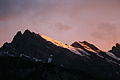
View of the Gspaltenhorn from Gimmelwald

View from Gimmelwald
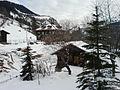
The former school house

A typical residential chalet in Gimmelwald


.jpg)


literature
- Christian Graf: History of the Lauterbrunnen Valley . Ed .: Lauterbrunnen community. Lauterbrunnen 1989, OCLC 75548597 .
Individual evidence
- ↑ https://www.seilbahninventar.ch/objekt.php?objid=40501&lang=de
- ↑ BAK (2015): List of sites of national importance. Archive link ( Memento of the original from April 13, 2016 in the Internet Archive ) Info: The archive link was inserted automatically and has not yet been checked. Please check the original and archive link according to the instructions and then remove this notice.
- ↑ Michel Hans: Book of the valley community Lauterbrunnen. 1240-1949 . P. Ruch-Daulte, Wengen 1962.
- ↑ http://www.schulhaus-gimmelwald.ch
- ↑ https://www.bernerzeitung.ch/region/oberland/jetzt-wird-es-konkret/story/12237523
- ↑ http://www.klettersteig-muerren.ch/