
Stechelberg
| Stechelberg | |
|---|---|
 |
|
| State : |
|
| Canton : |
|
| Administrative district : | Interlaken-Oberhasli |
| Residential municipality : | Lauterbrunnen |
| Postal code : | 3824 |
| UN / LOCODE : | CH |
| Coordinates : | 635 617 / 154962 |
| Height : | 910 m above sea level M. |
| Area : | 50.9 km² |
| Residents: | 201 (December 31, 2018) |
| Population density : | 4 inhabitants per km² |
| Website: | www.stechelberg.ch |
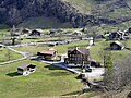
 View from the Schilthorn cable car to Stechelberg |
|
| map | |
 |
|
Stechelberg is a small village in the Bernese Oberland and part of the Lauterbrunnen community .
history
In 1749 the name Stächelbärg for the rear end of the valley appears for the first time . At Trachsellauenen you come across the ruins of an ore smelting plant , here iron ore was mined and smelted. The forests that were cleared at the time have been reforested so that this nature reserve is in top condition. Due to the avalanches in 2003, individual areas of the nature reserve were affected, which are currently being reforested.
The school house was built in 1868. The post bus line to Lauterbrunnen was opened in 1950. With the construction of the Schilthornbahn in 1965, Stechelberg was connected to tourism.
On February 6, 2003, two dust avalanches rushed into the village. Due to the nature of the avalanches, however, there was no major damage, apart from the broken flagpoles, uprooted trees and broken window panes. Due to the very heavy snowfall and the continuing risk of avalanches, the residents were not allowed to leave the houses and the school was closed for the time being. A group of young people visiting the Naturfreundehaus Stechelberg was evacuated to the nearby Camping Jungfrau in the night of February 6th to 7th with the help of Postbuses. Floods and foehn storms also often affect the residents.
Location and transport links
Stechelberg is at the end of the road through the Lauterbrunnen valley and is therefore the last village in the Lauterbrunnen community . There are transport connections with the cable car to Gimmelwald , Mürren and the Schilthorn , on foot to Trachsellauenen and over the weather gap to the Valais .
Residents
Stechelberg has 255 inhabitants (2009).
| year | 1827 | 1900 | 1910 | 1930 | 1941 | 1960 | 1970 | 1980 | 2005 | 2014 | 2018 |
|---|---|---|---|---|---|---|---|---|---|---|---|
| Residents | 107 | 374 | 414 | 386 | 382 | 324 | 334 | 278 | 272 | 250 | 201 |
tourism
The rear end of the Lauterbrunnen valley is a large nature reserve. It is also part of the Swiss Alps Jungfrau-Aletsch UNESCO World Heritage Site . Stechelberg is the starting point for many high mountain tours.
photos
View of the southern part of Stechelberg from the footpath to Gimmelwald
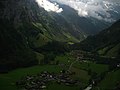
Stechelberg, view from the Schilthornbahn


literature
- Andrea Jundt: In the barnacle . Zytglogge Verlag , 2003, ISBN 3-7296-0659-X .
- Hans Buchs: School and village chronicle Stechelberg . Verlag Schlaefli and Maurer, 2005, ISBN 3-85884-012-2 .
- Hans Mans: Book of the Lauterbrunnen valley. 1240-1949 . Publishing house P. Ruch-Daulte, Wengen 1962.