
Brienzwiler
| Brienzwiler | |
|---|---|
 |
|
| State : |
|
| Canton : |
|
| Administrative district : | Interlaken-Oberhasli |
| BFS no. : | 0574 |
| Postal code : | 3856 |
| Coordinates : | 650 669 / 177977 |
| Height : | 680 m above sea level M. |
| Height range : | 572–2891 m above sea level M. |
| Area : | 17.64 km² |
| Residents: | 479 (December 31, 2018) |
| Population density : | 31 inhabitants per km² |
| Mayor : | Daniel Schild-von Allmen |
| Website: | www.brienzwiler.ch |
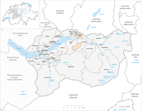
| Location of the municipality | |
  |
|
Brienzwiler is a municipality in the Interlaken-Oberhasli administrative district in the canton of Bern in Switzerland .
Brienzwiler is a so-called mixed community , so the residents and civic communities are one unit.
Place name
The name Wiler goes back to the Old High German wilari (small village) and is a loan word from the Romanesque villare (farmstead). The name Brienzwiler has only been documented since 1850, before that the addition -am Brünig was always added to differentiate between other Wilers .
geography
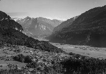
The town of Brienzwiler is located in the Bernese Oberland at the foot of the Wilerhorn on a hill above Lake Brienz . Brienzwiler also includes the Balmhof settlement , which lies further down in the Aare valley under a steep rock ( Balm ). The neighboring communities starting from the north in a clockwise direction are: Lungern , Meiringen , Brienz and Hofstetten bei Brienz .
In addition, a piece of uninhabited mountain range belongs to the municipality, which is completely separated from the village, but makes up the greater part of the municipality in terms of area. Its neighboring communities are Meiringen , Grindelwald and Brienz . The highest mountain there is the Wildgärst at 2891 m above sea level. M.
politics
Daniel Schild-von Allmen has been mayor since 2017, succeeding Hans Schild-Stähli, who was in office for 8 years.
traffic
The community has its own connection to the A8 motorway . The Meiringen - Interlaken line of the Zentralbahn runs past the southern border of the municipality , with two stops at Brienzwiler (at Balmhof) and Unterbach . Both stops are, however, far from the village center. The village itself and the Ballenberg are served by the post bus line from Brienz to Hasliberg.
The Meiringen military airfield of the Swiss Air Force is in the valley outside the municipality .
Attractions
The biggest attraction in Brienzwiler is the Ballenberg , the largest open-air museum in Switzerland.
Web links
- Website of the municipality of Brienzwiler
- Anne-Marie Dubler : Brienzwiler. In: Historical Lexicon of Switzerland .
Individual evidence
- ↑ Permanent resident population from STAT-TAB of the BfS , municipalities see also regional portraits 2020 on bfs.admin.ch, accessed on May 29, 2020
Beatenberg | Bönigen | Brienz | Brienzwiler | Därligen | Grindelwald | Gsteigwiler | Gündlischwand | Guttannen | Habkern | Hasliberg | Hofstetten near Brienz | Innertkirchen | Interlaken | Iseltwald | Lauterbrunnen | Leissigen | Lütschental | Mats near Interlaken | Meiringen | Niederried near Interlaken | Oberried am Brienzersee | Ringgenberg | Saxeten | Shadow half | Schwanden near Brienz | Unterseen | Wilderswil
Former parishes: Ebligen | Gadmen | Goldswil | Isenfluh
Canton of Bern | Administrative districts of the canton of Bern | Municipalities of the Canton of Bern