
Bönigen
| Bönigen | |
|---|---|
 |
|
| State : |
|
| Canton : |
|
| Administrative district : | Interlaken-Oberhasli |
| BFS no. : | 0572 |
| Postal code : | 3806 |
| Coordinates : | 634788 / 170619 |
| Height : | 568 m above sea level M. |
| Height range : | 564–2292 m above sea level M. |
| Area : | 15.08 km² |
| Residents: | 2536 (December 31, 2018) |
| Population density : | 151 inhabitants per km² |
| Website: | www.boenigen.ch |
 Bönigen (in the foreground) |
|
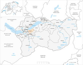
| Location of the municipality | |
  |
|
Bönigen is a municipality in the Interlaken-Oberhasli administrative district in the canton of Bern in Switzerland .
Surname
The name Bönigen "among the people, the Bono clan" is made up of the Old High German personal name Bono (from the Latin bonus "good") and the place-name broadcast -ingun .
geography
Bönigen is located in the Bernese Oberland on the south bank of Lake Brienz . The neighboring communities starting from the north and clockwise are: Iseltwald , Gündlischwand , Gsteigwiler , Matten bei Interlaken , Wilderswil and Interlaken .
The flat alluvial plain between Lake Brienz and Lake Thun, on which the village lies, is called Bödeli .
The actual village center is located on the north-western border of the municipality along the Lütschine to the lake and is almost fused with Interlaken. The largest part of the municipality in terms of area consists of a steep mountain slope with the Loucherhorn (2230 m. Above sea level), the Roteflue (2296 m. Above sea level) and the Schynige Platte at its peaks .

population
| Population development | |||||||||||
|---|---|---|---|---|---|---|---|---|---|---|---|
| year | 1764 | 1850 | 1880 | 1900 | 1930 | 1950 | 1960 | 1970 | 1980 | 1990 | 2000 |
| Residents | 346 | 1,263 | 1'519 | 1'515 | 1'547 | 1,734 | 1,833 | 1,738 | 1,835 | 2,041 | 2,182 |
politics
The mayor is Herbert Seiler (as of 2010). In addition to the residents' community, there is also a civic community under the name Bönigen .
traffic
The A8 motorway runs along the shores of Lake Brienz . From 1874 to 1969 Bönigen was developed with a 2.2 km long standard-gauge railway line from Interlaken Ost (part of the Bödelibahn ), which has only been used as a siding to the BLS AG workshop in Bönigen since then.
church
Bönigen belongs to the Gsteig parish near Interlaken .
coat of arms
|
|
Blazon : “ Divided by gold and silver with a gold-crowned eagle , and of silver with half a black ibex. » |
| Reasons for the coat of arms: The imperial eagle recalls the time before 1275 when Bönigen was an imperial village . The ibex refers to the coat of arms of the Interlaken landscape, to which Bönigen belonged until 1798. The municipal coat of arms has been in use in this form since 1922. |
See also
literature
- Paul Michel: Bönigen . Bönigen 1989, ISBN 3-905454-01-7
- Book of arms of the canton of Bern. The Bernese state coat of arms and the coats of arms of the administrative districts and municipalities , published on behalf of the Bernese government council. by the management of the municipalities, arr. from the Bern State Archives with the assistance of Hans Jenni. Armorial du canton de Berne. Les armoiries de l'Etat de Berne, des districts et des communes , publié par la Direction des affaires communales sur mandat du Conseil-exécutif du canton de Berne, élaboré par les Archives de l'Etat de Berne avec la collaboration de Hans Jenni, Bern 1981.
Web links
- Official website of the municipality of Bönigen
- Anne-Marie Dubler : Bönigen. In: Historical Lexicon of Switzerland .
Individual evidence
- ↑ Permanent resident population from STAT-TAB of the BfS , municipalities see also regional portraits 2020 on bfs.admin.ch, accessed on May 29, 2020
- ↑ Alfred Helfenstein: The Namengut Pilate territory. Keller, Luzern 1982, ISBN 3-85766-004-X , p. 43.
- ↑ Interlaken Ost - Bönigen , discontinued railways of Switzerland
- ↑ Wappenbuch 1981, p. 112.
- ↑ Wappenbuch 1981, p. 112.
Beatenberg | Bönigen | Brienz | Brienzwiler | Därligen | Grindelwald | Gsteigwiler | Gündlischwand | Guttannen | Habkern | Hasliberg | Hofstetten near Brienz | Innertkirchen | Interlaken | Iseltwald | Lauterbrunnen | Leissigen | Lütschental | Mats near Interlaken | Meiringen | Niederried near Interlaken | Oberried am Brienzersee | Ringgenberg | Saxeten | Shadow half | Schwanden near Brienz | Unterseen | Wilderswil
Former parishes: Ebligen | Gadmen | Goldswil | Isenfluh
Canton of Bern | Administrative districts of the canton of Bern | Municipalities of the Canton of Bern