
Gsteigwiler
| Gsteigwiler | |
|---|---|
 |
|
| State : |
|
| Canton : |
|
| Administrative district : | Interlaken-Oberhasli |
| BFS no. : | 0577 |
| Postal code : | 3814 |
| Coordinates : | 633401 / 167178 |
| Height : | 645 m above sea level M. |
| Height range : | 583-2099 m above sea level M. |
| Area : | 7.03 km² |
| Residents: | 406 (December 31, 2018) |
| Population density : | 60 inhabitants per km² |
| Mayor : | Urs Stucki |
| Website: | www.gsteigwiler.ch |
_109.JPG) View from the Harderbahn to Gsteigwiler, Wilderswil and Matten |
|
| Location of the municipality | |
  |
|
Gsteigwiler is a municipality in the Interlaken-Oberhasli administrative district in the Swiss canton of Bern .
In addition to the residents' community, there is also a civic community of the same name.
Place name
The original name of Gsteigwiler was "Wiler" and goes back to the old high German wilari (small village). The addition Gsteig- was used to differentiate the numerous other Wilers and means «abrupt incline of a mountain that cannot be climbed by car».
geography
Gsteigwiler is located in the Bernese Oberland at the foot of the Schynige Platte in a valley. The neighboring communities starting from the north in a clockwise direction are: Matten bei Interlaken , Bönigen , Gündlischwand and Wilderswil . The Lütschine flows in the valley .
politics
Mayor is Urs Stucki (as of 2019).
traffic
The railway line of the Berner Oberland-Bahnen runs through the valley from Interlaken to Zweilütschinen , although the village has no train station / stop. The connection to the public transport takes place every hour with the bus line 105 to Wilderswil and Interlaken West. This is operated by PostBus Bern. The intermediate stations Rotenegg (service station) and Breitlauenen of the Schynige Platte Railway , a tourist railway , are located in the municipality .
Parish
The Gsteig church (built in the 12th century on the site of a previous church) stands on the soil of the political community of Gsteigwiler and is the center of one of the largest parishes (Reformation 1528) in the canton of Bern. The church has important wall paintings.
Attractions
photos

Gsteig Church
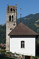
Gsteig Church

Steeple

Fresco (church wall)

Grave of the daughter of Felix Mendelssohn Bartholdy
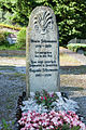
Grave of two daughters of Robert Schumann

Christian boarding school Gsteigwiler


literature
- Anne-Marie Dubler : Gsteigwiler. In: Historical Lexicon of Switzerland .
- Anne-Marie Dubler: Gsteig near Interlaken. In: Historical Lexicon of Switzerland .
- Heinz Häsler : Gsteigwiler: Pictures of a small community . Gsteigwiler, 1995, ISBN 3-85884-052-1
Web links
Individual evidence
- ↑ Permanent resident population from STAT-TAB of the BfS , municipalities see also regional portraits 2020 on bfs.admin.ch, accessed on May 29, 2020
Beatenberg | Bönigen | Brienz | Brienzwiler | Därligen | Grindelwald | Gsteigwiler | Gündlischwand | Guttannen | Habkern | Hasliberg | Hofstetten near Brienz | Innertkirchen | Interlaken | Iseltwald | Lauterbrunnen | Leissigen | Lütschental | Mats near Interlaken | Meiringen | Niederried near Interlaken | Oberried am Brienzersee | Ringgenberg | Saxeten | Shadow half | Schwanden near Brienz | Unterseen | Wilderswil
Former parishes: Ebligen | Gadmen | Goldswil | Isenfluh
Canton of Bern | Administrative districts of the canton of Bern | Municipalities of the Canton of Bern