
Habkern
| Habkern | |
|---|---|
 |
|
| State : |
|
| Canton : |
|
| Administrative district : | Interlaken-Oberhasli |
| BFS no. : | 0579 |
| Postal code : | 3804 |
| Coordinates : | 631 452 / 174021 |
| Height : | 1055 m above sea level M. |
| Height range : | 740–2197 m above sea level M. |
| Area : | 50.96 km² |
| Residents: | 639 (December 31, 2018) |
| Population density : | 12 inhabitants per km² |
| Website: | www.habkern.ch |
_079.JPG) Habkern |
|
| Location of the municipality | |
  |
|
Habkern is a municipality in the Interlaken-Oberhasli administrative district in the canton of Bern in Switzerland .
In addition to the resident community, there is an Evangelical Reformed parish under this name.
Surname
The name Habkern is formed from the Old High German generic word habuh (hawk, sparrowhawk, falcon) and the ending -arra (means that something occurs in large numbers). Habkern is therefore "the place where there are many hawks".
geography
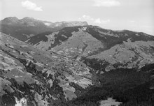
Habkern is located in the Bernese Oberland on the border with the Emmental , which is formed by the Hohgant . The neighboring communities starting from the north in a clockwise direction are Schangnau , Flühli in the canton of Lucerne , Oberried am Brienzersee , Niederried near Interlaken , Unterseen , Beatenberg and Eriz . The place consists of the farmers Bohlseiten, Bort, Schwendi and Mittelbäuert, the actual village center. The Siebenhengste-Hohgant-Höhle is located in the underground of the community . The Augstmatthorn lies above Habkern-Bolsite .
The Luegibodenblock , the largest boulder in Switzerland, is located in the Lombachtal near Habkern .
history
Habcherron was first mentioned in 1275 when King Rudolf made an exchange with Baron von Eschenbach. In 1308 after the assassination of King Albrecht I of Habsburg, the town fell to Habsburg Austria and later to the Interlaken monastery. The inhabitants of Habkern suffered from raids by the Unterwaldner, especially in 1342; they rose up against the monastery from 1348 to 1349 and in 1445 belonged to the Evil League of the Upper Lands. The Reformation was introduced in 1528 after only a short resistance, Habkern was taken from Goldswil and assigned to the Unterseen parish; this came to the Landvogtei Interlaken in 1529. From 1538 an Evangelical Reformed church service was celebrated once a month in Habkern, and in 1565 a branch church was established. With the new church building in 1666, Habkern became an independent Evangelical Reformed parish.
Alpine farming with hard cheese production and cattle export have been the main work and a good source of income since the Middle Ages. The glassworks in Harzersboden contributed to the deforestation of the area from 1720 to 1778, followed by milk sugar boiling in the 19th century. In 1828 Habkern received a drivable road from Unterseen for the first time, but even this could not prevent poverty and emigration to the Unterland or abroad at the end of the 19th century because new methods such as pasteurization and cooling in milk processing reduced the international importance of hard cheese.
politics
The executive branch of the Habkern community, the community council , consists of nine members. Mayor is Markus Karlen, SVP (as of 2016).
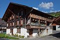
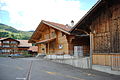
photos
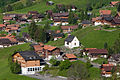
Mittelbäuert (school buildings)
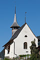
church
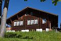
Parish Hall
mat

Bol sides
Mittelbäuert


_075.JPG)
_087.JPG)
population
| Population development | ||||||||||||
|---|---|---|---|---|---|---|---|---|---|---|---|---|
| year | 1764 | 1850 | 1880 | 1900 | 1930 | 1950 | 1960 | 1970 | 1980 | 1990 | 2000 | 2017 |
| Residents | 365 | 724 | 839 | 781 | 678 | 671 | 625 | 651 | 580 | 608 | 624 | 640 |
economy
Mountain agriculture and soft tourism are the most important branches of business in Habkern. In 2018 there were still around 55 farms with 1,400 head of cattle in the summer of 6 Alps with 20 dairies. The two restaurants, four dormitories and around 40 holiday apartments generated 16,000 overnight stays per year in 2017. Hikers and locals use the hourly postbus connection with Interlaken and skiers use the one ski lift.
See also
literature
- JC Remijn: Church history of Unterseen , 1979
- Melchior Sooder: Habkern , Basel 1964 and 1982
Web links
- Official website of the municipality of Habkern
- Anne-Marie Dubler : Habkern. In: Historical Lexicon of Switzerland .
Individual evidence
- ↑ Permanent resident population from STAT-TAB of the BfS , municipalities see also regional portraits 2020 on bfs.admin.ch, accessed on May 29, 2020
- ^ Anne-Marie Dubler : Habkern. In: Historical Lexicon of Switzerland .
- ↑ Commune Habkern - Bernese Oberland Switzerland: Commune Habkern - Bernese Oberland Switzerland. Retrieved May 8, 2017 .
- ↑ Peter Grunder: The Crisis in Alpine Tourism - Interlaken's Boutique-Station , GastroJournal, March 15, 2018, p. 8
Beatenberg | Bönigen | Brienz | Brienzwiler | Därligen | Grindelwald | Gsteigwiler | Gündlischwand | Guttannen | Habkern | Hasliberg | Hofstetten near Brienz | Innertkirchen | Interlaken | Iseltwald | Lauterbrunnen | Leissigen | Lütschental | Mats near Interlaken | Meiringen | Niederried near Interlaken | Oberried am Brienzersee | Ringgenberg | Saxeten | Shadow half | Schwanden near Brienz | Unterseen | Wilderswil
Former parishes: Ebligen | Gadmen | Goldswil | Isenfluh
Canton of Bern | Administrative districts of the canton of Bern | Municipalities of the Canton of Bern