Hohgant
| Hohgant | ||
|---|---|---|
|
The north side of the Hohgant of Schangnau seen from |
||
| height | 2197 m above sea level M. | |
| location | Canton of Bern , Switzerland | |
| Mountains | Emmental Alps | |
| Dominance | 6.45 km → Tannhorn | |
| Notch height | 638 m ↓ Alp Lombach | |
| Coordinates | 635 381 / 181974 | |
|
|
||
| rock | Helvetic sediment | |
| Age of the rock | Tethys | |
The Hohgant ( [ˌhoːˈɡant] ) is a mountain range in the Emmental Alps in the Swiss canton of Bern .
location
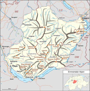
The mountain is located about 12 km north-northeast of Interlaken (as the crow flies) in the rear Emmental . The communities Habkern , Schangnau and Eriz have a share in the Hohgant massif .
The Hohgant massif consists of a 7 km long mountain range , which is oriented towards the west- south- west-east-north-east. The main peaks are from west to east: Trogenhorn ( 1973 m above sea level ), Hohgant West ( 2063 m above sea level ), Hohgant (Steinigi Matte, 2163 m above sea level ), Furggegütsch ( [ˈfʊrkəˌɡʏtʃ] ; with 2197 m above sea level the highest peak of the Bergstock) and Brünneligrind ( 1790 m above sea level ). The Hohgant is bounded in the southeast, east and north by the course of the Emme , which rises in the area between the Hohgant and Augstmatthorn , in the west by the Eriz basin, in the south-west by the Grüenenbergpass ( Saumpass ) and in the south by the Traubach basin. To the northeast, the edge chain of the Hohgant continues beyond the deeply cut Emme in the Schrattenfluh ; in the southwest the Grüenenbergpass leads over to the seven stallions . Towards the north and west, the Hohgant falls very steeply with its rugged rock faces, while the slopes are much less steep towards the south.

geology
From a geological point of view, the Hohgant consists of sediments from the Helvetic Mountains , which were deposited around 225 to 65 million years ago on the northern edge of the ancient Mediterranean Sea, Tethys . These layers were only included in the folding of the Alps relatively late, around 20 million years ago . As Abscherungs - and thrust horizon that served incompetent flysch and marl of Ultrahelvetikums. Today the following layers can be seen on the northern slope of the Hohgant:
- Subalpine molasse and flysch zone in the relatively gently sloping lower slope areas (made up of extensive alpine pastures)
- Silica limestone of the Hauterivium and Drusberg layers of the Barremium , partly grassy, partly steep slopes interspersed with rivers
- Schrattenkalk of the Aptium , a distinctive light gray limestone layer up to 200 m thick
- Hohgantsandstein, forms the summit area of the Hohgant and was deposited around 50 million years ago in the Tertiary .
The layers dip towards the south and southeast. In those places where the Schrattenkalk appears on the surface, typical karst phenomena such as cart fields and sinkholes could develop. In the chalky subsoil of the Hohgant and the neighboring mountains, the Siebenhengste-Hohgant Cave is one of the largest cave systems on earth.
Flora and fauna
On the southern slopes of the Hohgant there are larger mountain pine forests , interspersed with alpine lawns and some moor areas. The flora in the summit area is heavily dependent on the geological subsoil, species-rich limestone alpine flora alternates with vegetation that has established itself on weathered sandstone. There are several ibex colonies on the Hohgant . The area has been under nature protection since 1974.
Web links
- Hohgant on hikr.org


