
Schibengütsch
| Schibengütsch | ||
|---|---|---|
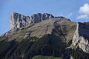
 Schiebengütsch from Kemmeribodenbad |
||
| height | 2037 m above sea level M. | |
| location | Canton of Lucerne Switzerland | |
| Mountains | Emmental Alps | |
| Dominance | 1.26 km → Hangs | |
| Notch height | 46 m ↓ unnamed notch | |
| Coordinates | 638 900 / 184905 | |
|
||
| rock | Schrattenkalk | |

The Schibengütsch (also: Schibegütsch ) is a mountain peak in the Swiss canton of Lucerne .
The Schibengütsch is 2037 m high and forms the south-western end of the Schrattenfluh mountain range . The Schrattenfluh is accessible from several sides by hiking trails. Starting points for hikes, for example, from the southeast, the Salwideli , from the southwest, the Kemmeribodenbad and from the west, the Marbachegg .
Surname
It takes its name from the Schiengütsch sheep alp Schibe ( standarddt. "Slice") at its southern slope; this in turn got its name due to the strikingly even, flattened pasture and scree fields.
Until the 19th century, the mountain was called Scheibenfluh ; the name Schybengütsch is first recorded in 1812.
gallery


Schrattenfluh: Schybengütsch summit build-up from the southwest
Schrattenfluh: Schybengütsch (left) & Achs (right) from the south

Schrattenfluh: Schybengütsch summit construction from the northwest

Schrattenfluh-Südostabdachung: Schybengütsch

Hiking sign on the summit with a view north to the Hengst

The summit

Schiebengütsch seen from the Oberimbergli


Web links
- Schibegütsch on hikr.org